Otto Pozehl
| Birth | : | 13 Sep 1902 Seward County, Nebraska, USA |
| Death | : | 22 Apr 1984 Utica, Seward County, Nebraska, USA |
| Burial | : | Saint Brigid Cemetery, Millbury, Worcester County, USA |
| Coordinate | : | 42.1951900, -71.7690100 |
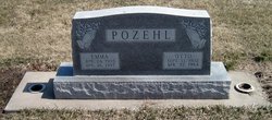
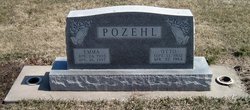
| Inscription | : | POZEHL Emma Apr. 24, 1903 April 26, 1997 Otto Sept. 13, 1902 Apr. 22, 1984 |
| Description | : | Extract from the 1910 Census: Name: Otto Pozehl Age in 1910: 7 Estimated birth year: 1903 Birthplace: Nebraska Race: white Sex: male Relationship to head of family: son Parents: Fritz and Marie Pozehl, ages 51 and 41 Home in 1910: Sharon, Buffalo, Nebraska Marital status: single Father's birthplace: Germany Mother's birthplace: Illinois Occupation: attending school Father's occupation: farmer Siblings living at home: Minnie (age 19), Christe (18), Carl (16), Martha (14), Annie (12), Fritz (9), Marie (3), and Lydia (0/12) Census place: Sharon, Buffalo, Nebraska; Roll: T624_839; Page: 4B; Enumeration District: 50; Image: 1454 Date: 23 Apr 1910 Extract... Read More |
frequently asked questions (FAQ):
-
Where is Otto Pozehl's memorial?
Otto Pozehl's memorial is located at: Saint Brigid Cemetery, Millbury, Worcester County, USA.
-
When did Otto Pozehl death?
Otto Pozehl death on 22 Apr 1984 in Utica, Seward County, Nebraska, USA
-
Where are the coordinates of the Otto Pozehl's memorial?
Latitude: 42.1951900
Longitude: -71.7690100
Family Members:
Parent
Spouse
Siblings
Children
Flowers:
Nearby Cemetories:
1. Saint Brigid Cemetery
Millbury, Worcester County, USA
Coordinate: 42.1951900, -71.7690100
2. Millbury Central Cemetery
Millbury, Worcester County, USA
Coordinate: 42.1939621, -71.7682953
3. Millbury Cemetery
Millbury, Worcester County, USA
Coordinate: 42.1914940, -71.7515945
4. Dwinell Cemetery
Millbury, Worcester County, USA
Coordinate: 42.1990100, -71.7945000
5. Freegrace Marble Farm Cemetery
Sutton, Worcester County, USA
Coordinate: 42.1637500, -71.7507600
6. West Millbury Cemetery
Millbury, Worcester County, USA
Coordinate: 42.1714249, -71.8044434
7. Quinsigamond Cemetery (Defunct)
Worcester, Worcester County, USA
Coordinate: 42.2268580, -71.7952640
8. Wilkinsonville Cemetery
Sutton, Worcester County, USA
Coordinate: 42.1716450, -71.7225750
9. Saint John's Episcopal Church Burial Site
Sutton, Worcester County, USA
Coordinate: 42.1745870, -71.7196110
10. Sutton Center Cemetery
Sutton, Worcester County, USA
Coordinate: 42.1492540, -71.7632000
11. Saint Thomas Church Memorial Garden
Auburn, Worcester County, USA
Coordinate: 42.1918392, -71.8315460
12. New Howard Cemetery
Sutton, Worcester County, USA
Coordinate: 42.1514620, -71.7475300
13. Old Howard Cemetery
Sutton, Worcester County, USA
Coordinate: 42.1513220, -71.7478470
14. Hillside Cemetery
Auburn, Worcester County, USA
Coordinate: 42.1972008, -71.8319016
15. Cole-Woodbury Cemetery
Sutton, Worcester County, USA
Coordinate: 42.1463310, -71.7676440
16. Saint Philips Catholic Cemetery
Grafton, Worcester County, USA
Coordinate: 42.2028008, -71.7027969
17. Auburn Center Burial Ground
Auburn, Worcester County, USA
Coordinate: 42.1940575, -71.8367920
18. Armsby Cemetery
Sutton, Worcester County, USA
Coordinate: 42.1516991, -71.7319031
19. College of the Holy Cross Cemetery
Worcester, Worcester County, USA
Coordinate: 42.2390600, -71.8067000
20. Putnam Cemetery
Sutton, Worcester County, USA
Coordinate: 42.1431500, -71.7800100
21. Carpenter Cemetery
Sutton, Worcester County, USA
Coordinate: 42.1425500, -71.7599300
22. Riverside Cemetery
Grafton, Worcester County, USA
Coordinate: 42.2057266, -71.6985550
23. Batcheller Farm Cemetery
Sutton, Worcester County, USA
Coordinate: 42.1434880, -71.7887510
24. Orchard View Cemetery
Sutton, Worcester County, USA
Coordinate: 42.1613760, -71.7107900

