

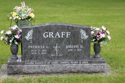

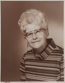
Patricia “Pat” Lenz Graff
| Birth | : | 25 Jul 1931 Early, Sac County, Iowa, USA |
| Death | : | 3 Apr 2013 Spencer, Clay County, Iowa, USA |
| Burial | : | Riverside Cemetery, Spencer, Clay County, USA |
| Coordinate | : | 43.1441994, -95.1671982 |
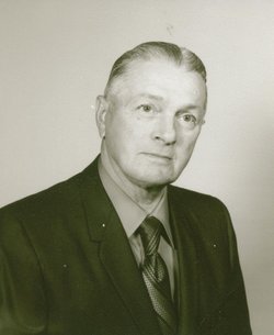
| Description | : | Mrs. Graff passed away Wednesday, April 3, at Longhouse Residence in Spencer. Patricia Graff, the daughter of Carl and Madeline (Koewler) Lenz was born July 25, 1931, in Early. Her childhood years were spent on a farm near Early, where she received her education, graduating from Early Consolidated School. Pat met Joseph Graff in 1949 and they were married on July 19, 1954 at St. Joseph's Catholic Church in Sioux Rapids. They lived for a short time in Omaha, Nebraska, while Joe attended school, and then moved to Spencer, where Pat lived the rest of her life. Pat worked as a telephone... Read More |
frequently asked questions (FAQ):
-
Where is Patricia “Pat” Lenz Graff's memorial?
Patricia “Pat” Lenz Graff's memorial is located at: Riverside Cemetery, Spencer, Clay County, USA.
-
When did Patricia “Pat” Lenz Graff death?
Patricia “Pat” Lenz Graff death on 3 Apr 2013 in Spencer, Clay County, Iowa, USA
-
Where are the coordinates of the Patricia “Pat” Lenz Graff's memorial?
Latitude: 43.1441994
Longitude: -95.1671982
Family Members:
Parent
Spouse

Siblings
Flowers:


Nearby Cemetories:
1. Riverside Cemetery
Spencer, Clay County, USA
Coordinate: 43.1441994, -95.1671982
2. Dewey Readmore Books Memorial
Spencer, Clay County, USA
Coordinate: 43.1403999, -95.1443024
3. North Lawn Cemetery
Spencer, Clay County, USA
Coordinate: 43.1600000, -95.1470000
4. Evergreen Cemetery
Clay County, USA
Coordinate: 43.2052994, -95.2086029
5. Fairview Cemetery
Clay County, USA
Coordinate: 43.1899986, -95.0800018
6. Swedish Lutheran Cemetery
Royal, Clay County, USA
Coordinate: 43.0683000, -95.2350000
7. Dickens Cemetery
Dickens, Clay County, USA
Coordinate: 43.1280000, -95.0155000
8. Rosehill Cemetery
Clay County, USA
Coordinate: 43.0368996, -95.0919037
9. Lone Tree Cemetery
Everly, Clay County, USA
Coordinate: 43.1411018, -95.3347015
10. Little Sioux Lutheran Cemetery
Milford, Dickinson County, USA
Coordinate: 43.2702065, -95.2109528
11. First Reformed Cemetery
Clay County, USA
Coordinate: 43.2399500, -95.2889000
12. Lincoln Cemetery
Rossie, Clay County, USA
Coordinate: 43.0111008, -95.2313995
13. Willow Creek Cemetery
Royal, Clay County, USA
Coordinate: 43.0214005, -95.2885971
14. Liberty Cemetery
Greenville, Clay County, USA
Coordinate: 42.9897003, -95.1417007
15. Clay Center Cemetery
Royal, Clay County, USA
Coordinate: 43.0410995, -95.3272018
16. Milford Cemetery
Milford, Dickinson County, USA
Coordinate: 43.3092003, -95.1481018
17. TriMello Cemetery
Royal, Clay County, USA
Coordinate: 43.0682983, -95.3728027
18. Logan Township Cemetery
Clay County, USA
Coordinate: 43.0489006, -94.9747009
19. Zion Methodist Cemetery
Clay County, USA
Coordinate: 42.9808006, -95.2497025
20. Calvary Cemetery
Milford, Dickinson County, USA
Coordinate: 43.3213997, -95.1688995
21. Fanny Fern Cemetery
Clay County, USA
Coordinate: 42.9530983, -95.1607971
22. Crown Hill Cemetery
Ruthven, Palo Alto County, USA
Coordinate: 43.1328011, -94.8878021
23. Calvary Cemetery
Ruthven, Palo Alto County, USA
Coordinate: 43.1314011, -94.8869019
24. Westport Cemetery
Dickinson County, USA
Coordinate: 43.3130989, -95.3289032