
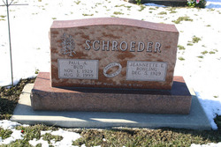
Paul Allen “Bud” Schroeder
| Birth | : | 1 Nov 1929 |
| Death | : | 2 Aug 1999 Lost Nation, Clinton County, Iowa, USA |
| Burial | : | Fort Rosecrans National Cemetery, San Diego, San Diego County, USA |
| Coordinate | : | 32.6887894, -117.2449417 |
| Description | : | Married: Jeannette L. Rohling Schroeder 30 March 1952. Parents of: Mark, Chris & Cary. ~ OST NATION, Iowa -- Services for Paul "Bud" Schroeder, of Lost Nation, will be 10:30 a.m. Thursday at Bethlehem Lutheran Church, Lost Nation. Burial will be in Lost Nation Cemetery. Visitation is 3-8 p.m. today at Hayden Funeral Home, Lost Nation. Mr. Schroeder died Monday, Aug. 2, 1999, at his home, after a brief illness. He was born Nov. 1, 1929, on the family farm west of Lost Nation. He married Jeannette Rohling in 1952 in Lost Nation. The couple farmed the family farm. He was associated 30... Read More |
frequently asked questions (FAQ):
-
Where is Paul Allen “Bud” Schroeder's memorial?
Paul Allen “Bud” Schroeder's memorial is located at: Fort Rosecrans National Cemetery, San Diego, San Diego County, USA.
-
When did Paul Allen “Bud” Schroeder death?
Paul Allen “Bud” Schroeder death on 2 Aug 1999 in Lost Nation, Clinton County, Iowa, USA
-
Where are the coordinates of the Paul Allen “Bud” Schroeder's memorial?
Latitude: 32.6887894
Longitude: -117.2449417
Family Members:
Parent

Siblings
Flowers:


Nearby Cemetories:
1. Fort Rosecrans National Cemetery
San Diego, San Diego County, USA
Coordinate: 32.6887894, -117.2449417
2. Westminster Presbyterian Church Columbarium
San Diego, San Diego County, USA
Coordinate: 32.7228160, -117.2427620
3. All Souls Episcopal Church Columbarium
San Diego, San Diego County, USA
Coordinate: 32.7315950, -117.2425880
4. Christ Episcopal Church Memorial Garden
Coronado, San Diego County, USA
Coordinate: 32.6866970, -117.1784000
5. Bum Dog Burial Site
San Diego, San Diego County, USA
Coordinate: 32.7105700, -117.1606500
6. El Campo Santo Cemetery
San Diego, San Diego County, USA
Coordinate: 32.7514000, -117.1922989
7. Presidio Hill Cemetery
Old Town San Diego, San Diego County, USA
Coordinate: 32.7592960, -117.1949920
8. Calvary Cemetery
San Diego, San Diego County, USA
Coordinate: 32.7489014, -117.1766968
9. Saint Pauls Episcopal Cathedral Columbarium
San Diego, San Diego County, USA
Coordinate: 32.7340800, -117.1595900
10. First Unitarian Universalist Church of San Diego
San Diego, San Diego County, USA
Coordinate: 32.7535730, -117.1664870
11. Saint Andrews by the Sea Church Columbarium
Pacific Beach, San Diego County, USA
Coordinate: 32.7950430, -117.2496340
12. Home of Peace Cemetery
San Diego, San Diego County, USA
Coordinate: 32.7052002, -117.1150970
13. Mount Hope Cemetery
San Diego, San Diego County, USA
Coordinate: 32.7111890, -117.1121660
14. Cypress View Mausoleum and Crematory
San Diego, San Diego County, USA
Coordinate: 32.7050018, -117.1081009
15. First United Methodist Church Memorial Garden
San Diego, San Diego County, USA
Coordinate: 32.7674040, -117.1425440
16. Greenwood Memorial Park
San Diego, San Diego County, USA
Coordinate: 32.7057991, -117.1025009
17. Nhu Lai Thien Tu Temple Columbarium
San Diego County, USA
Coordinate: 32.7411200, -117.1084400
18. Holy Cross Cemetery
San Diego, San Diego County, USA
Coordinate: 32.7168999, -117.0975037
19. Normal Heights United Methodist Church Columbarium
San Diego, San Diego County, USA
Coordinate: 32.7625900, -117.1186200
20. La Vista Memorial Park
National City, San Diego County, USA
Coordinate: 32.6638985, -117.0727997
21. Beth Sarim House
San Diego, San Diego County, USA
Coordinate: 32.7712330, -117.0992590
22. Mission San Diego de Alcala Cemetery
San Diego, San Diego County, USA
Coordinate: 32.7858009, -117.1103973
23. Mount Soledad National Veterans Memorial
La Jolla, San Diego County, USA
Coordinate: 32.8398800, -117.2446900
24. Saint James By-The-Sea Episcopal Church Cemetery
La Jolla, San Diego County, USA
Coordinate: 32.8448240, -117.2767710