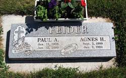
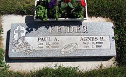
Paul Anthony Feider
| Birth | : | 12 Jan 1908 Pomeroy, Garfield County, Washington, USA |
| Death | : | 12 Jan 2000 Clarkston, Asotin County, Washington, USA |
| Burial | : | New Salem Baptist Church Cemetery, Kynesville, Jackson County, USA |
| Coordinate | : | 30.7458270, -85.3078750 |
| Description | : | Paul Anthony Feider Sr., retired Garfield County farmer and road department worker, died of causes related to age Wednesday at Angelito's Adult Family Home in Clarkston. It was his 92nd birthday. He was born Jan. 12, 1908, at Pomeroy to Anthony and Elizabeth Pierre Feider. He attended the Catholic school at Pomeroy. On June 6, 1939, he married Agnes Holm at Holy Rosary Catholic Church at Pomeroy. For several years, he managed the Mission Shell Service Station at Pomeroy. Later, from 1946 to 1948, they farmed at Milton-Freewater, Ore. They then returned to Garfield County and farmed... Read More |
frequently asked questions (FAQ):
-
Where is Paul Anthony Feider's memorial?
Paul Anthony Feider's memorial is located at: New Salem Baptist Church Cemetery, Kynesville, Jackson County, USA.
-
When did Paul Anthony Feider death?
Paul Anthony Feider death on 12 Jan 2000 in Clarkston, Asotin County, Washington, USA
-
Where are the coordinates of the Paul Anthony Feider's memorial?
Latitude: 30.7458270
Longitude: -85.3078750
Family Members:
Parent
Spouse
Siblings
Flowers:
Nearby Cemetories:
1. New Salem Baptist Church Cemetery
Kynesville, Jackson County, USA
Coordinate: 30.7458270, -85.3078750
2. Damascas Freewill Baptist Cemetery
Marianna, Jackson County, USA
Coordinate: 30.7484000, -85.2887000
3. Mount Ararat A.M.E. Church Cemetery
Marianna, Jackson County, USA
Coordinate: 30.7698460, -85.3142880
4. Mount Olive AME Church Cemetery
Marianna, Jackson County, USA
Coordinate: 30.7208230, -85.3054040
5. Bellamy Cemetery
Marianna, Jackson County, USA
Coordinate: 30.7770900, -85.3116800
6. Spears Plantation Cemetery
Marianna, Jackson County, USA
Coordinate: 30.7813880, -85.3133330
7. Caraway Cemetery
Marianna, Jackson County, USA
Coordinate: 30.7538310, -85.2663720
8. Bright Prospect Cemetery
Marianna, Jackson County, USA
Coordinate: 30.7174797, -85.2768021
9. Porter Cemetery
Grand Ridge, Jackson County, USA
Coordinate: 30.7372948, -85.2626553
10. Antioch AME Church Cemetery
Marianna, Jackson County, USA
Coordinate: 30.7843910, -85.2880670
11. Bethlehem Baptist Church Cemetery
Jackson County, USA
Coordinate: 30.7307000, -85.3541000
12. New Hope Baptist Church Cemetery
Marianna, Jackson County, USA
Coordinate: 30.7829400, -85.2831520
13. Florida Industrial School for Boys Cemetery
Marianna, Jackson County, USA
Coordinate: 30.7663850, -85.2619500
14. Kynesville United Methodist Church Cemetery
Kynesville, Jackson County, USA
Coordinate: 30.7305490, -85.3587380
15. Ebenezer Baptist Church Cemetery
Jackson County, USA
Coordinate: 30.7042920, -85.3317760
16. Everitt Family Burial Ground
Cottondale, Jackson County, USA
Coordinate: 30.7524500, -85.3622200
17. Gray Cemetery
Cottondale, Jackson County, USA
Coordinate: 30.7860180, -85.3551540
18. Baxter-Morgan Memorial Gardens
Marianna, Jackson County, USA
Coordinate: 30.7230600, -85.2468900
19. Orange Hill Cemetery
Marianna, Jackson County, USA
Coordinate: 30.7719002, -85.2438965
20. Roulhac Cemetery
Marianna, Jackson County, USA
Coordinate: 30.7558002, -85.2356033
21. Long Cemetery
Marianna, Jackson County, USA
Coordinate: 30.7851000, -85.2462000
22. Bethlehem A.M.E. Church Cemetery
Marianna, Jackson County, USA
Coordinate: 30.8078460, -85.3390180
23. Dykes Cemetery
Marianna, Jackson County, USA
Coordinate: 30.7612572, -85.2305679
24. New Galilee Missionary Baptist Church Cemetery
Marianna, Jackson County, USA
Coordinate: 30.7220535, -85.2307281

