
| Birth | : | 12 Jan 1924 Clarke County, Iowa, USA |
| Death | : | 8 Mar 2018 Ringgold County, Iowa, USA |
| Burial | : | Murray Cemetery, Murray, Clarke County, USA |
| Coordinate | : | 41.0278015, -93.9456024 |
| Inscription | : | wed Oct 4 1946 |
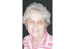
| Description | : | Paul Clifton Smith was born to Milo and Ida (Driver) Smith on January 12, 1924 in Clarke County. He was the 4th oldest of 15 children. He went to school in Clarke County and helped his dad on the farm. In March 1943 he went into the service, he was 1st Marine Division 5th regiment, 3rd battalion, Company I . He served in the Pacific Islands seeing combat on New Guinea, New Britain, Peleliu and Okinawa. He was discharged January 1946. On October 4, 1946 he married Ardella Marie Newton in Rock Falls, Illinois. To this union was born Jerry... Read More |
frequently asked questions (FAQ):
-
Where is Paul Clifton Smith's memorial?
Paul Clifton Smith's memorial is located at: Murray Cemetery, Murray, Clarke County, USA.
-
When did Paul Clifton Smith death?
Paul Clifton Smith death on 8 Mar 2018 in Ringgold County, Iowa, USA
-
Where are the coordinates of the Paul Clifton Smith's memorial?
Latitude: 41.0278015
Longitude: -93.9456024
Family Members:
Parent

Spouse
Siblings

Flowers:


Nearby Cemetories:
1. Murray Cemetery
Murray, Clarke County, USA
Coordinate: 41.0278015, -93.9456024
2. Bell Family Cemetery
Murray, Clarke County, USA
Coordinate: 41.0625267, -93.9240036
3. Sanders Cemetery
Doyle Township, Clarke County, USA
Coordinate: 40.9730000, -93.9016000
4. Claypool Cemetery
Thayer, Union County, USA
Coordinate: 41.0126114, -94.0303497
5. Thayer Catholic Cemetery
Thayer, Union County, USA
Coordinate: 41.0374985, -94.0357971
6. Olinger Cemetery
Union County, USA
Coordinate: 40.9690208, -94.0274887
7. Hopeville Cemetery
Hopeville, Clarke County, USA
Coordinate: 40.9450000, -93.9870000
8. West Union Cemetery
Thayer, Union County, USA
Coordinate: 41.0191994, -94.0721970
9. Bethel Cemetery
Thayer, Union County, USA
Coordinate: 41.0600014, -94.0693970
10. Lacelle Cemetery
Clarke County, USA
Coordinate: 40.9446500, -93.8690300
11. Union Cemetery
Murray, Clarke County, USA
Coordinate: 41.1265000, -93.9115000
12. Beulah Cemetery
Thayer, Union County, USA
Coordinate: 41.0589981, -94.0759964
13. Pierson Cemetery
Osceola, Clarke County, USA
Coordinate: 40.9954491, -93.8131104
14. Monette Cemetery
Lorimor, Union County, USA
Coordinate: 41.0800743, -94.0715866
15. Cox Cemetery
Osceola, Clarke County, USA
Coordinate: 41.0722008, -93.8142014
16. Otterbein Cemetery
Thayer, Union County, USA
Coordinate: 40.9990005, -94.0879974
17. Gregg Cemetery
Doyle Township, Clarke County, USA
Coordinate: 40.9138000, -93.9520000
18. Lorimor Cemetery
Lorimor, Union County, USA
Coordinate: 41.1128006, -94.0516968
19. Browns Mountain Cemetery
Thayer, Union County, USA
Coordinate: 41.0499992, -94.0999985
20. Mount Pisgah Cemetery
Thayer, Union County, USA
Coordinate: 41.0511017, -94.1007996
21. Maple Hill Cemetery
Osceola, Clarke County, USA
Coordinate: 41.0278015, -93.7794037
22. Homewood Cemetery
Thayer, Union County, USA
Coordinate: 40.9220009, -94.0419998
23. Warrick Cemetery
Decatur County, USA
Coordinate: 40.8960000, -93.9234000
24. Leas Cemetery
Union County, USA
Coordinate: 40.9080009, -94.0220032