
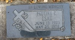
Pauline C. Toews Esau
| Birth | : | 13 Jun 1923 Swalwell, Strathmore Census Division, Alberta, Canada |
| Death | : | 25 May 1978 Linden, Strathmore Census Division, Alberta, Canada |
| Burial | : | Rosedale Cemetery, Ridge Valley, Grande Cache Census Division, Canada |
| Coordinate | : | 55.1553800, -117.9257900 |
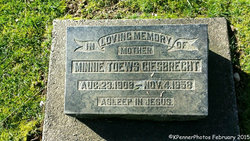
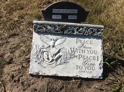
| Inscription | : | IN LOVING MEMORY |
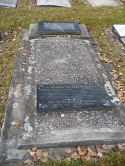
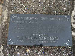
| Description | : | With thanks to Jcarter (#48847489) for the additional bio information: Published n the Messenger of Truth Issue 13, 1978: Our beloved mother, Pauline Esau, daughter of Jacob L. and Mary Toews, was born on June 13, 1923, at Swalwell, Alberta, and peacefully passed away in the Linden Nursing Home in the evening of May 25, 1978, just before her fifty-fifth birthday. She grew up in the Swalwell area and in her teenage years, accepted Christ, and was baptized, becoming a member of the Church of God in Christ, Mennonite. On July 28, 1946, she married Oliver Esau, moving to the Crooked Creek... Read More |
frequently asked questions (FAQ):
-
Where is Pauline C. Toews Esau's memorial?
Pauline C. Toews Esau's memorial is located at: Rosedale Cemetery, Ridge Valley, Grande Cache Census Division, Canada.
-
When did Pauline C. Toews Esau death?
Pauline C. Toews Esau death on 25 May 1978 in Linden, Strathmore Census Division, Alberta, Canada
-
Where are the coordinates of the Pauline C. Toews Esau's memorial?
Latitude: 55.1553800
Longitude: -117.9257900
Family Members:
Parent

Spouse
Siblings

Children
Flowers:


Nearby Cemetories:
1. Rosedale Cemetery
Ridge Valley, Grande Cache Census Division, Canada
Coordinate: 55.1553800, -117.9257900
2. Crooked Creek Cemetery
Crooked Creek, Grande Cache Census Division, Canada
Coordinate: 55.1557900, -117.9261900
3. Ridge Valley Hutterite Colony Cemetery
Ridge Valley, Grande Cache Census Division, Canada
Coordinate: 55.1200417, -117.9499081
4. Debolt Community Cemetery
Debolt, Grande Cache Census Division, Canada
Coordinate: 55.2160600, -117.9996400
5. Goodwin Cemetery
Goodwin, Grande Cache Census Division, Canada
Coordinate: 55.2243233, -118.2073975
6. Sturgeon Lake Cemetery
Sturgeon Lake, Grande Cache Census Division, Canada
Coordinate: 55.0745000, -117.5000600
7. Fox Creek Roman Catholic Cemetery
Belloy, Grande Prairie Census Division, Canada
Coordinate: 55.4333600, -118.0019000
8. Glen Leslie Cemetery
Grande Prairie, Grande Prairie Census Division, Canada
Coordinate: 55.2006200, -118.4604800
9. Teepee Creek Cemetery
Teepee Creek, Grande Prairie Census Division, Canada
Coordinate: 55.4028900, -118.4099000
10. Valleyview and District Cemetery
Valleyview, Grande Cache Census Division, Canada
Coordinate: 55.0826900, -117.2497000
11. Whitemud Creek Cemetery
Whitemud Creek, Grande Prairie Census Division, Canada
Coordinate: 55.4621180, -117.4768680
12. New Fish Creek Cemetery
New Fish Creek, Grande Cache Census Division, Canada
Coordinate: 55.2948816, -117.2590103
13. St. Stevens Anglican
Teepee Creek, Grande Prairie Census Division, Canada
Coordinate: 55.3736200, -118.5636400
14. Emmaus Lutheran Cemetery
Teepee Creek, Grande Prairie Census Division, Canada
Coordinate: 55.4028400, -118.5621800
15. Bear Creek Cemetery
Grande Prairie, Grande Prairie Census Division, Canada
Coordinate: 55.1259028, -118.7674333
16. Birch Hills Hutterite Colony Cemetery
Wanham, Grande Prairie Census Division, Canada
Coordinate: 55.5875110, -118.3489060
17. Heart Valley Cemetery
Wanham, Grande Prairie Census Division, Canada
Coordinate: 55.5885630, -118.3874170
18. City of Grande Prairie Cemetery
Grande Prairie, Grande Prairie Census Division, Canada
Coordinate: 55.1556000, -118.8315500
19. Webster Cemetery
Sexsmith, Grande Prairie Census Division, Canada
Coordinate: 55.4339114, -118.6929042
20. Emerson Trail Cemetery
Sexsmith, Grande Prairie Census Division, Canada
Coordinate: 55.3164800, -118.8351600
21. Codesa Hutterite Cemetery
Codesa, Grande Prairie Census Division, Canada
Coordinate: 55.7064300, -118.0703500
22. Pleasant Heights Cemetery
Eaglesham, Grande Prairie Census Division, Canada
Coordinate: 55.7123300, -117.8808800
23. Shady Lane Hutterite Colony Cemetery
Wanham, Grande Prairie Census Division, Canada
Coordinate: 55.7200058, -118.2310000
24. Watino Cemetery
Watino, Grande Prairie Census Division, Canada
Coordinate: 55.7234800, -117.6117500