
| Birth | : | 3 Nov 1935 Stratton, Hitchcock County, Nebraska, USA |
| Death | : | 19 Feb 2022 McCook, Red Willow County, Nebraska, USA |
| Burial | : | Saint Marys Cemetery, Herndon, Rawlins County, USA |
| Coordinate | : | 39.9160995, -100.7994003 |
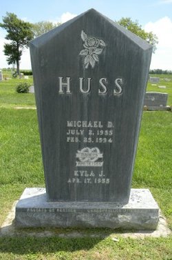
| Description | : | Pauline "Pat" Joan (Huss) Glebe, 86, of McCook, formerly of Stratton, Neb., died Saturday (Feb. 19, 2022) at Community Hospital in McCook. Pat was born in Stratton on November 3, 1935 to parents Paul M and Mary Leona (Heilers) Haller. She was one of six children who were raised on the family farm south of Stratton. Pat graduated from Stratton High School with the Class of 1953. On August 3, 1954, Pat married Donald Huss in Stratton. The couple made Herndon, KS their home and were blessed with three children. Donald preceded Pat in death. |
frequently asked questions (FAQ):
-
Where is Pauline Joan “Pat” Haller Huss-Glebe's memorial?
Pauline Joan “Pat” Haller Huss-Glebe's memorial is located at: Saint Marys Cemetery, Herndon, Rawlins County, USA.
-
When did Pauline Joan “Pat” Haller Huss-Glebe death?
Pauline Joan “Pat” Haller Huss-Glebe death on 19 Feb 2022 in McCook, Red Willow County, Nebraska, USA
-
Where are the coordinates of the Pauline Joan “Pat” Haller Huss-Glebe's memorial?
Latitude: 39.9160995
Longitude: -100.7994003
Family Members:
Parent

Spouse
Siblings
Children
Flowers:


Nearby Cemetories:
1. Saint Marys Cemetery
Herndon, Rawlins County, USA
Coordinate: 39.9160995, -100.7994003
2. Union Cemetery
Herndon, Rawlins County, USA
Coordinate: 39.9255981, -100.7957993
3. Evangelical Cemetery
Herndon, Rawlins County, USA
Coordinate: 39.9160995, -100.7577972
4. Saint John's Lutheran Cemetery
Logan Township, Decatur County, USA
Coordinate: 39.8931100, -100.7397900
5. Hamper Cemetery
Ludell, Rawlins County, USA
Coordinate: 39.8819008, -100.9075012
6. Swedish Baptist Cemetery
Rawlins County, USA
Coordinate: 39.8217010, -100.8153000
7. Traer Lutheran Cemetery
Logan Township, Decatur County, USA
Coordinate: 39.8715400, -100.6839400
8. Covenant Cemetery
Herndon, Rawlins County, USA
Coordinate: 39.8143997, -100.8244019
9. Swedish Lutheran Cemetery
Rawlins County, USA
Coordinate: 39.8135986, -100.7782974
10. Traer Cemetery
Traer, Decatur County, USA
Coordinate: 39.9296989, -100.6457977
11. Saint Johns Lutheran Cemetery
Oberlin, Decatur County, USA
Coordinate: 39.8430520, -100.6772920
12. Trinity Lutheran Cemetery
Ludell, Rawlins County, USA
Coordinate: 39.9230995, -100.9625015
13. Palmer Graves
Trenton, Hitchcock County, USA
Coordinate: 40.0436500, -100.8562500
14. Immanuel Lutheran Cemetery
Ludell, Rawlins County, USA
Coordinate: 39.8610730, -100.9627840
15. Rose Hill Cemetery
Ludell, Rawlins County, USA
Coordinate: 39.8400290, -100.9536050
16. Cornell Cemetery
Trenton, Hitchcock County, USA
Coordinate: 40.0031013, -100.9642029
17. Penn Family Cemetery
Oberlin, Decatur County, USA
Coordinate: 39.8679700, -100.5892500
18. Pleasant Prairie Cemetery
Red Willow County, USA
Coordinate: 40.0247002, -100.6097031
19. Cedar Bluffs Cemetery
Decatur County, USA
Coordinate: 39.9883003, -100.5717010
20. Achilles Cemetery
Achilles, Rawlins County, USA
Coordinate: 39.7117004, -100.8328018
21. Grove Cemetery
Culbertson, Hitchcock County, USA
Coordinate: 40.1222000, -100.8146973
22. Bassettville Cemetery
Oberlin, Decatur County, USA
Coordinate: 39.7064018, -100.7213974
23. Mount Calvary Cemetery
Atwood, Rawlins County, USA
Coordinate: 39.8133011, -101.0569000
24. Atwood Fairview Cemetery
Atwood, Rawlins County, USA
Coordinate: 39.8063820, -101.0579090