Pauline Kubli Crawford
| Birth | : | 19 Oct 1929 Moniteau County, Missouri, USA |
| Death | : | 5 Mar 2015 Columbia, Boone County, Missouri, USA |
| Burial | : | Sappington Community Chapel Cemetery, California, Moniteau County, USA |
| Coordinate | : | 38.5770500, -92.6026700 |
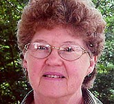
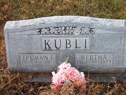
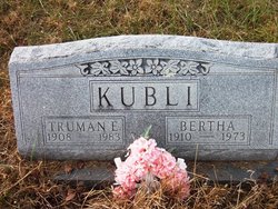
| Description | : | Pauline, 85, of California, Missouri passed away Thrusday, March 5th 2015 at Boone Hospital Center Columbia, Missouri. She was born in rural Moniteau County to Truman and Bertha Schwab Kubli. Pauline taught in the rural California R-1 School District. Pauline was a member of the Friendship Baptist Church, She was very active with the Children's Church Ministries including teaching Sunday school and vacation bible school, as well as being involved with Baptist Women. She was a very loving wife, mother, grandmother and caregiver for her grandsons, Michael and Ryan, after the death of their mother. For 30 years, she... Read More |
frequently asked questions (FAQ):
-
Where is Pauline Kubli Crawford's memorial?
Pauline Kubli Crawford's memorial is located at: Sappington Community Chapel Cemetery, California, Moniteau County, USA.
-
When did Pauline Kubli Crawford death?
Pauline Kubli Crawford death on 5 Mar 2015 in Columbia, Boone County, Missouri, USA
-
Where are the coordinates of the Pauline Kubli Crawford's memorial?
Latitude: 38.5770500
Longitude: -92.6026700
Family Members:
Parent
Spouse
Siblings
Children
Flowers:

Pauline, I just found out that you had passed. My prayers go out to Bob and the rest of your family. God Bless and rest in peace.
Left by Anonymous on 01 Aug 2015

Pauline, Just thinking of you today.
Left by Anonymous on 01 Apr 2016

Pauline, Happy Thanksgiving in heaven.
Left by Anonymous on 19 Nov 2018

Left by Anonymous on 03 Mar 2019
Nearby Cemetories:
1. Sappington Community Chapel Cemetery
California, Moniteau County, USA
Coordinate: 38.5770500, -92.6026700
2. Norman Cemetery
High Point, Moniteau County, USA
Coordinate: 38.5681700, -92.5691300
3. Old Latham Cemetery
Latham, Moniteau County, USA
Coordinate: 38.5466400, -92.5891100
4. Flag Spring Cemetery
California, Moniteau County, USA
Coordinate: 38.6102900, -92.6187800
5. McKissick Family Cemetery
California, Moniteau County, USA
Coordinate: 38.6124900, -92.5815400
6. Gamble Cemetery
California, Moniteau County, USA
Coordinate: 38.5393982, -92.5757980
7. Boeckhaus Cemetery
California, Moniteau County, USA
Coordinate: 38.6225100, -92.5862700
8. Anderson Cemetery
Moniteau County, USA
Coordinate: 38.6130500, -92.5617700
9. Hutchison-Houchin Family Cemetery
California, Moniteau County, USA
Coordinate: 38.6245900, -92.5821200
10. Marney Family Cemetery
High Point, Moniteau County, USA
Coordinate: 38.5357900, -92.5614500
11. Latham Cemetery
Latham, Moniteau County, USA
Coordinate: 38.5643997, -92.6680984
12. Brown Family Cemetery
California, Moniteau County, USA
Coordinate: 38.5862100, -92.5308800
13. Union Christian Church Cemetery
High Point, Moniteau County, USA
Coordinate: 38.5196390, -92.5994260
14. Saint Pauls Lutheran Cemetery
California, Moniteau County, USA
Coordinate: 38.6304200, -92.5725100
15. California Odd Fellows Cemetery
California, Moniteau County, USA
Coordinate: 38.6303820, -92.5721960
16. Annunciation Catholic Cemetery
California, Moniteau County, USA
Coordinate: 38.6310400, -92.5711000
17. Elliott Cemetery
Moniteau County, USA
Coordinate: 38.5244500, -92.6408700
18. Pleasant Hill Cemetery
Moniteau County, USA
Coordinate: 38.5329500, -92.6590800
19. California Masonic Cemetery
California, Moniteau County, USA
Coordinate: 38.6276900, -92.5547300
20. Yarnell Cemetery
California, Moniteau County, USA
Coordinate: 38.5189018, -92.5708008
21. California City Cemetery
California, Moniteau County, USA
Coordinate: 38.6275170, -92.5518830
22. Evangelical Cemetery
California, Moniteau County, USA
Coordinate: 38.6273100, -92.5513700
23. Crown Hill City Cemetery
California, Moniteau County, USA
Coordinate: 38.6272060, -92.5508770
24. Spring Hill Mennonite Cemetery
Latham, Moniteau County, USA
Coordinate: 38.5537900, -92.6824100

