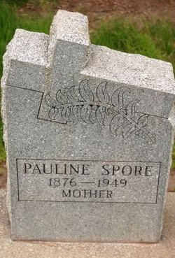
Pauline Virginia Bohart Spore
| Birth | : | 1876 Missouri, USA |
| Death | : | 1949 Grand Junction, Mesa County, Colorado, USA |
| Burial | : | Liberty Hill Baptist Church Cemetery, Catawba, York County, USA |
| Coordinate | : | 34.8286660, -80.9384350 |
| Inscription | : | Mother |
frequently asked questions (FAQ):
-
Where is Pauline Virginia Bohart Spore's memorial?
Pauline Virginia Bohart Spore's memorial is located at: Liberty Hill Baptist Church Cemetery, Catawba, York County, USA.
-
When did Pauline Virginia Bohart Spore death?
Pauline Virginia Bohart Spore death on 1949 in Grand Junction, Mesa County, Colorado, USA
-
Where are the coordinates of the Pauline Virginia Bohart Spore's memorial?
Latitude: 34.8286660
Longitude: -80.9384350
Family Members:
Parent
Spouse
Siblings
Children
Flowers:
Nearby Cemetories:
1. Liberty Hill Baptist Church Cemetery
Catawba, York County, USA
Coordinate: 34.8286660, -80.9384350
2. Catawba Chapel A.M.E. Zion Church Cemetery
Catawba, York County, USA
Coordinate: 34.8555500, -80.9262500
3. Catawba Methodist Church Cemetery
Catawba, York County, USA
Coordinate: 34.8506851, -80.9131012
4. Harmony Baptist Church Cemetery
Edgemoor, Chester County, USA
Coordinate: 34.8046250, -80.9690760
5. Bethel United Methodist Church Cemetery
Edgemoor, Chester County, USA
Coordinate: 34.7921600, -80.9321100
6. Mount Calvary AME Zion Church Cemetery
Rock Hill, York County, USA
Coordinate: 34.8445778, -80.9860687
7. Neely's Creek ARP Church Cemetery
Rock Hill, York County, USA
Coordinate: 34.8673260, -80.9651080
8. Tabernacle AME Zion Church Cemetery
Rock Hill, York County, USA
Coordinate: 34.8749847, -80.9308090
9. Old Stone Cemetery
Fort Lawn, Chester County, USA
Coordinate: 34.7905870, -80.9053250
10. New Covenant Church
Chester County, USA
Coordinate: 34.7818130, -80.9198320
11. Nichols Family Cemetery
Edgemoor, Chester County, USA
Coordinate: 34.7734860, -80.9251110
12. Rives Family Burying Grounds
Edgemoor, Chester County, USA
Coordinate: 34.7990600, -80.9970000
13. Mount Zion AME Zion Church Cemetery
Landsford, Chester County, USA
Coordinate: 34.7743200, -80.9175800
14. New Vision Freewill Baptist Church Cemetery
Rock Hill, York County, USA
Coordinate: 34.8520660, -81.0023010
15. Hopewell Presbyterian Church Cemetery
Lesslie, York County, USA
Coordinate: 34.8835320, -80.9648800
16. Edgemoor ARP Church Cemetery
Edgemoor, Chester County, USA
Coordinate: 34.8055800, -81.0104000
17. Red Oak AME Zion Church Cemetery
Edgemoor, Chester County, USA
Coordinate: 34.8019210, -81.0123740
18. Mount Hebron Baptist Church Cemetery
Rock Hill, York County, USA
Coordinate: 34.8943270, -80.9506690
19. Big Calvary Baptist Church Cemetery
Edgemoor, Chester County, USA
Coordinate: 34.7882180, -81.0050820
20. Mount Holly United Methodist Church Cemetery
Rock Hill, York County, USA
Coordinate: 34.8674278, -81.0165024
21. White Oak AME Zion Church Cemetery
Van Wyck, Lancaster County, USA
Coordinate: 34.8487570, -80.8484340
22. El Bethel United Methodist Church Cemetery
Chester County, USA
Coordinate: 34.7513590, -80.9194850
23. Van Wyck Presbyterian Church
Van Wyck, Lancaster County, USA
Coordinate: 34.8537520, -80.8471870
24. Catawba Baptist Church Cemetery
Rock Hill, York County, USA
Coordinate: 34.9066887, -80.9643478


