
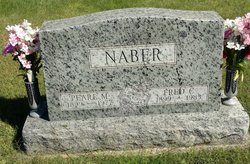
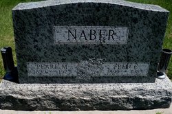
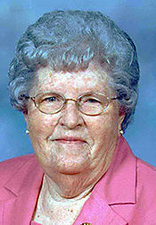
Pearl Marie Louise Holscher Naber
| Birth | : | 7 Aug 1899 Nebraska, USA |
| Death | : | Oct 1977 Syracuse, Otoe County, Nebraska, USA |
| Burial | : | St. Mary of Stogumber Churchyard, Stogumber, West Somerset District, England |
| Coordinate | : | 51.1276170, -3.2902340 |
| Plot | : | Lot-11 #1N |
frequently asked questions (FAQ):
-
Where is Pearl Marie Louise Holscher Naber's memorial?
Pearl Marie Louise Holscher Naber's memorial is located at: St. Mary of Stogumber Churchyard, Stogumber, West Somerset District, England.
-
When did Pearl Marie Louise Holscher Naber death?
Pearl Marie Louise Holscher Naber death on Oct 1977 in Syracuse, Otoe County, Nebraska, USA
-
Where are the coordinates of the Pearl Marie Louise Holscher Naber's memorial?
Latitude: 51.1276170
Longitude: -3.2902340
Family Members:
Parent
Spouse

Siblings

Children
Flowers:


Nearby Cemetories:
1. St. Mary of Stogumber Churchyard
Stogumber, West Somerset District, England
Coordinate: 51.1276170, -3.2902340
2. All Saints Churchyard
Monksilver, West Somerset District, England
Coordinate: 51.1287770, -3.3262800
3. Saint George Churchyard
Bicknoller, West Somerset District, England
Coordinate: 51.1472610, -3.2722430
4. St. Martin de Tours Churchyard
Elworthy, West Somerset District, England
Coordinate: 51.1066110, -3.3113586
5. St. George's Churchyard
Sampford Brett, West Somerset District, England
Coordinate: 51.1538990, -3.3033380
6. St Mary Church
Nettlecombe, West Somerset District, England
Coordinate: 51.1312930, -3.3491000
7. St Peter's Churchyard
Williton, West Somerset District, England
Coordinate: 51.1584870, -3.3235670
8. Holy Ghost Churchyard
Crowcombe, West Somerset District, England
Coordinate: 51.1232260, -3.2293260
9. St. Audries Churchyard
West Quantoxhead, West Somerset District, England
Coordinate: 51.1688420, -3.2717650
10. St John The Baptist Churchyard
Tolland, Taunton Deane Borough, England
Coordinate: 51.0826570, -3.2856680
11. Blessed Virgin Mary Churchyard
Brompton Ralph, West Somerset District, England
Coordinate: 51.0830230, -3.3077060
12. Lydeard St Lawrence Churchyard
Lydeard St Lawrence, Taunton Deane Borough, England
Coordinate: 51.0818820, -3.2462470
13. Watchet Town Cemetery
Watchet, West Somerset District, England
Coordinate: 51.1745790, -3.3379850
14. St Decuman's Churchyard
Watchet, West Somerset District, England
Coordinate: 51.1757020, -3.3383800
15. St. Giles Churchyard of Leighland
Old Cleeve, West Somerset District, England
Coordinate: 51.1199950, -3.3842729
16. St. Mary's Churchyard
Holford, West Somerset District, England
Coordinate: 51.1627900, -3.2074238
17. St. Andrew's Parish of Old Cleeve Churchyard
Old Cleeve, West Somerset District, England
Coordinate: 51.1683560, -3.3733090
18. St. Mary's Churchyard
East Quantoxhead, West Somerset District, England
Coordinate: 51.1855220, -3.2370690
19. Saint Mary Magdalene Churchyard
Clatworthy, West Somerset District, England
Coordinate: 51.0698450, -3.3534250
20. St. Pancras Churchyard
West Bagborough, Taunton Deane Borough, England
Coordinate: 51.0966990, -3.1890352
21. St Peter and St Paul Churchyard
Combe Florey, Taunton Deane Borough, England
Coordinate: 51.0735250, -3.2139050
22. All Saints Churchyard
Dodington, West Somerset District, England
Coordinate: 51.1583770, -3.1854620
23. Combe Florey Extension Cemetery
Combe Florey, Taunton Deane Borough, England
Coordinate: 51.0733900, -3.2120200
24. St Mary's Churchyard
Kilve, West Somerset District, England
Coordinate: 51.1883100, -3.2223530