
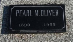
Pearl May See Oliver
| Birth | : | 17 Oct 1890 Scotland County, Missouri, USA |
| Death | : | 26 Feb 1953 Sand Hill, Scotland County, Missouri, USA |
| Burial | : | White Chapel Memorial Gardens, Wichita, Sedgwick County, USA |
| Coordinate | : | 37.7162018, -97.2806015 |
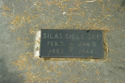
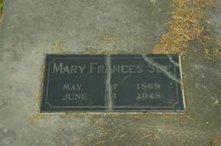
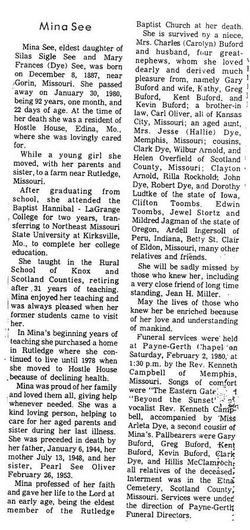
| Description | : | Memphis Democrat Memphis, Scotland, Missouri March 5, 1953 - P1, C5 Mrs. Carl Oliver Dies February 27 Pearlie May, daughter of Silas Sigle See and Mary Frances Dye See was born near Rutledge, October 17, 1890, and died February 27, 1953, at her home in Rutledge. She was married to Carl W. Oliver December 25, 1912, at Ft. Madison, Iowa, by the Rev. W. M. Cooney. She attended grade school at South Mt. Pleasant and Gorin and two years high school at the Gorin Academy. She lived in and near Rutledge her entire life and was a member of the Baptist Church... Read More |
frequently asked questions (FAQ):
-
Where is Pearl May See Oliver's memorial?
Pearl May See Oliver's memorial is located at: White Chapel Memorial Gardens, Wichita, Sedgwick County, USA.
-
When did Pearl May See Oliver death?
Pearl May See Oliver death on 26 Feb 1953 in Sand Hill, Scotland County, Missouri, USA
-
Where are the coordinates of the Pearl May See Oliver's memorial?
Latitude: 37.7162018
Longitude: -97.2806015
Family Members:
Parent
Spouse
Siblings


Nearby Cemetories:
1. White Chapel Memorial Gardens
Wichita, Sedgwick County, USA
Coordinate: 37.7162018, -97.2806015
2. Wichita Hebrew Cemetery
Wichita, Sedgwick County, USA
Coordinate: 37.7201004, -97.2798004
3. Mission Chapel Mausoleum
Wichita, Sedgwick County, USA
Coordinate: 37.7231200, -97.2955100
4. Old Mission Cemetery
Wichita, Sedgwick County, USA
Coordinate: 37.7243996, -97.2964020
5. Old Mission Mausoleum
Wichita, Sedgwick County, USA
Coordinate: 37.7242600, -97.2967400
6. Wichita Park Cemetery and Mausoleum
Wichita, Sedgwick County, USA
Coordinate: 37.7277985, -97.2960968
7. Maple Grove Cemetery
Wichita, Sedgwick County, USA
Coordinate: 37.7036018, -97.2949982
8. Highland Cemetery
Wichita, Sedgwick County, USA
Coordinate: 37.7028008, -97.3007965
9. Temple Emanuel Cemetery
Wichita, Sedgwick County, USA
Coordinate: 37.7014000, -97.3008000
10. Saint Stephen's Episcopal Church Columbarium
Wichita, Sedgwick County, USA
Coordinate: 37.6999272, -97.2505590
11. East Heights United Methodist Memorial Garden
Wichita, Sedgwick County, USA
Coordinate: 37.6854100, -97.2845500
12. Saint James Episcopal Church Columbarium
Wichita, Sedgwick County, USA
Coordinate: 37.6865600, -97.2930000
13. Calvary Cemetery
Wichita, Sedgwick County, USA
Coordinate: 37.6781006, -97.2949982
14. Mount Saint Mary Convent Cemetery
Wichita, Sedgwick County, USA
Coordinate: 37.6704000, -97.2904000
15. Saint Johns Episcopal Church Columbarium
Wichita, Sedgwick County, USA
Coordinate: 37.6918950, -97.3339670
16. Shirley Tilford Memorial Garden
Wichita, Sedgwick County, USA
Coordinate: 37.6942700, -97.3359600
17. Greenwich Cemetery
Wichita, Sedgwick County, USA
Coordinate: 37.7518997, -97.2266998
18. Ascension Cemetery
Bel Aire, Sedgwick County, USA
Coordinate: 37.7675018, -97.2533035
19. Lutheran Cemetery
Wichita, Sedgwick County, USA
Coordinate: 37.7664986, -97.2443008
20. Pierpont Cemetery
Sedgwick County, USA
Coordinate: 37.7011400, -97.2077500
21. Kensington Gardens Cemetery
Wichita, Sedgwick County, USA
Coordinate: 37.7230988, -97.2040024
22. Lakeview Cemetery & Mausoleum
Wichita, Sedgwick County, USA
Coordinate: 37.7086601, -97.1978989
23. Kechi Township Cemetery
Park City, Sedgwick County, USA
Coordinate: 37.8022003, -97.3000031
24. Adorers of The Blood of Christ Convent Cemetery
Wichita, Sedgwick County, USA
Coordinate: 37.6677700, -97.3787800