
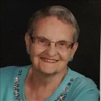
Pearl Tatum Kuskie
| Birth | : | 8 Sep 1927 |
| Death | : | 13 Aug 2020 Grant, Perkins County, Nebraska, USA |
| Burial | : | Fairview Cemetery, Grant, Perkins County, USA |
| Coordinate | : | 40.8372002, -101.7391968 |
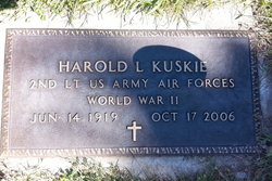
| Description | : | PEARL KUSKIE, 92 of Grant, NE, passed away Thursday, August 13, 2020, at Golden Ours Convalescent Home in Grant. Pearl was born September 8, 1927, to Orris and Ollie (Coppersmith) Tatum on a farm northeast of Elsie, NE. She was one of five children with two sisters and two brothers. She went to District 41 county school through the 8th grade and attended Grant High School for one year. Pearl was baptized and confirmed in the United Methodist Church and was a lifelong member. Pearl met and married Harold LeRoy Kuskie, and their marriage was blessed with three... Read More |
frequently asked questions (FAQ):
-
Where is Pearl Tatum Kuskie's memorial?
Pearl Tatum Kuskie's memorial is located at: Fairview Cemetery, Grant, Perkins County, USA.
-
When did Pearl Tatum Kuskie death?
Pearl Tatum Kuskie death on 13 Aug 2020 in Grant, Perkins County, Nebraska, USA
-
Where are the coordinates of the Pearl Tatum Kuskie's memorial?
Latitude: 40.8372002
Longitude: -101.7391968
Family Members:
Parent

Spouse
Siblings
Flowers:


Nearby Cemetories:
1. Fairview Cemetery
Grant, Perkins County, USA
Coordinate: 40.8372002, -101.7391968
2. Trinity Lutheran Cemetery
Grant, Perkins County, USA
Coordinate: 40.9605000, -101.7478000
3. Madrid Cemetery
Madrid, Perkins County, USA
Coordinate: 40.8371510, -101.5380900
4. Venango Cemetery
Venango, Perkins County, USA
Coordinate: 40.7416992, -102.0175018
5. Saint John's Lutheran Church Cemetery
Ogallala, Keith County, USA
Coordinate: 41.0617000, -101.5983000
6. Blanche Cemetery
Chase County, USA
Coordinate: 40.6841900, -101.4390900
7. Elsie Cemetery
Elsie, Perkins County, USA
Coordinate: 40.8499050, -101.3666140
8. Pickard Cemetery
Keith County, USA
Coordinate: 41.0482240, -101.4809320
9. Chase Cemetery
Chase, Chase County, USA
Coordinate: 40.5525017, -101.8078003
10. Brule Cemetery
Brule, Keith County, USA
Coordinate: 41.1060982, -101.8822021
11. Ogallala Cemetery
Ogallala, Keith County, USA
Coordinate: 41.1286011, -101.7472000
12. Boot Hill Cemetery
Ogallala, Keith County, USA
Coordinate: 41.1324997, -101.7256012
13. Walpole Cemetery
Perkins County, USA
Coordinate: 40.9157982, -101.3422012
14. Mount Hope Cemetery
Imperial, Chase County, USA
Coordinate: 40.5297012, -101.6607971
15. Amherst Cemetery
Phillips County, USA
Coordinate: 40.7056007, -102.1603012
16. Big Springs Cemetery
Big Springs, Deuel County, USA
Coordinate: 41.0592003, -102.0931015
17. Dunkard Cemetery
Amherst, Phillips County, USA
Coordinate: 40.6438000, -102.1356400
18. Greenlawn Cemetery
Lamar, Chase County, USA
Coordinate: 40.5231018, -101.9783020
19. Green Cemetery
Julesburg, Sedgwick County, USA
Coordinate: 40.8650000, -102.2284090
20. Lake View Cemetery
Champion, Chase County, USA
Coordinate: 40.4571991, -101.7705994
21. Saint John Catholic Cemetery
Hayes County, USA
Coordinate: 40.6027985, -101.3261032
22. Pleasant Valley Cemetery
Phillips County, USA
Coordinate: 40.5494003, -102.0899963
23. Pleasant Valley Cemetery
Yuma, Yuma County, USA
Coordinate: 40.5498000, -102.0909000
24. Paxton Cemetery
Paxton, Keith County, USA
Coordinate: 41.1088982, -101.3569031