
Percival Deshield Bailey
| Birth | : | 29 Apr 1827 Carrollton, Carroll County, Kentucky, USA |
| Death | : | 28 Jun 1912 Boise, Ada County, Idaho, USA |
| Burial | : | Sunset Memory Garden, Kokomo, Howard County, USA |
| Coordinate | : | 40.4393120, -86.1578320 |
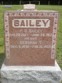
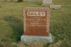
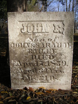
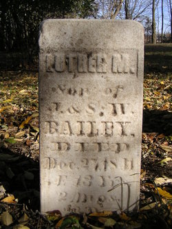
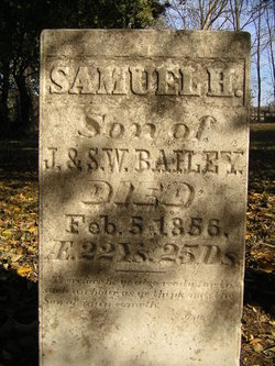
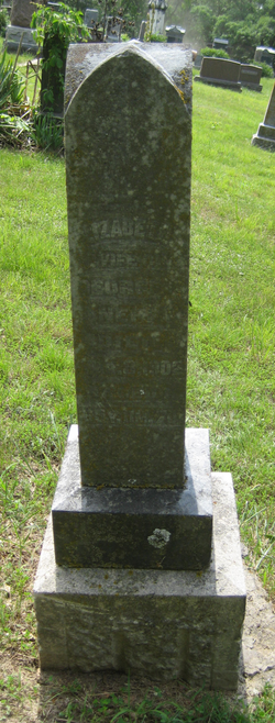
| Inscription | : | BAILEY ------ P. D. Bailey Apr 29 1827 - June 28 1912 His Wife Deborah T. Dec 8 1832 - Feb 15 1905 |
| Description | : | NOTE - To be historically correct, P. D. was born in Port William, Gallatin county, Kentucky. Carroll county wasn't formed until 1838, which included portions of Gallatin and other counties. Port William was then renamed Carrollton, all in honor of the last surviving signer of the Declaration of Independence. P. D. BAILEY, at one time a farmer residing on section 26, Elliott Township, came to Louisa county on the 19th of April, 1860. He was born in Carroll County, Ky., and was a son of John and Sarah (Goddard) Bailey, the former a native of Delaware, of Scotch... Read More |
frequently asked questions (FAQ):
-
Where is Percival Deshield Bailey's memorial?
Percival Deshield Bailey's memorial is located at: Sunset Memory Garden, Kokomo, Howard County, USA.
-
When did Percival Deshield Bailey death?
Percival Deshield Bailey death on 28 Jun 1912 in Boise, Ada County, Idaho, USA
-
Where are the coordinates of the Percival Deshield Bailey's memorial?
Latitude: 40.4393120
Longitude: -86.1578320
Family Members:
Parent
Spouse

Siblings

Children
Flowers:


Nearby Cemetories:
1. Sunset Memory Garden
Kokomo, Howard County, USA
Coordinate: 40.4393120, -86.1578320
2. Alto Baptist Cemetery
Kokomo, Howard County, USA
Coordinate: 40.4383940, -86.1653910
3. Cobb Cemetery
Kokomo, Howard County, USA
Coordinate: 40.4314790, -86.1464380
4. Randolph Cemetery
Kokomo, Howard County, USA
Coordinate: 40.4217100, -86.1270300
5. Highland Park
Kokomo, Howard County, USA
Coordinate: 40.4692310, -86.1440810
6. Heavens Hands Memory Garden and Burial Ground
Kokomo, Howard County, USA
Coordinate: 40.4146190, -86.1251730
7. Coleman Cemetery
Kokomo, Howard County, USA
Coordinate: 40.4764100, -86.1544800
8. Albright Cemetery
Kokomo, Howard County, USA
Coordinate: 40.4409680, -86.1080580
9. Young Cemetery
Kokomo, Howard County, USA
Coordinate: 40.4753500, -86.1881940
10. Saint Andrew's Episcopal Church Columbarium
Kokomo, Howard County, USA
Coordinate: 40.4857180, -86.1371580
11. Pioneer Cemetery
Kokomo, Howard County, USA
Coordinate: 40.4842800, -86.1246700
12. Puckett Cemetery
Kokomo, Howard County, USA
Coordinate: 40.4878006, -86.1868210
13. Twin Springs Cemetery
Kokomo, Howard County, USA
Coordinate: 40.4641280, -86.2244470
14. Crown Point Cemetery
Kokomo, Howard County, USA
Coordinate: 40.4868240, -86.1172340
15. Stringer Cemetery
Alto, Howard County, USA
Coordinate: 40.4859610, -86.2037270
16. Maria Regina Mater Monastery
Kokomo, Howard County, USA
Coordinate: 40.4936400, -86.1863820
17. Richardson Cemetery
Sharpsville, Tipton County, USA
Coordinate: 40.3865891, -86.1193008
18. Prairieville Cemetery
Groomsville, Tipton County, USA
Coordinate: 40.3960152, -86.2158279
19. Howard County Veterans Memorial
Kokomo, Howard County, USA
Coordinate: 40.4813580, -86.0975610
20. Kokomo Memorial Park Cemetery
Kokomo, Howard County, USA
Coordinate: 40.4980710, -86.1170840
21. Lower Kokomo Church Cemetery
Kokomo, Howard County, USA
Coordinate: 40.4412530, -86.0540540
22. Vawter Family Cemetery
Groomsville, Tipton County, USA
Coordinate: 40.3673760, -86.2058540
23. Shiloh Cemetery
Kokomo, Howard County, USA
Coordinate: 40.4895250, -86.2411520
24. Poff Cemetery
Howard County, USA
Coordinate: 40.4470210, -86.0512090