
| Birth | : | 31 Jan 1882 Harrison, Boone County, Arkansas, USA |
| Death | : | 22 Sep 1945 Wilderness, Oregon County, Missouri, USA |
| Burial | : | Oak Wood Cemetery, Pella, Marion County, USA |
| Coordinate | : | 41.4096870, -92.9282000 |
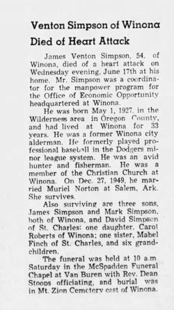
| Description | : | Peter Andrew SIMPSON, son of Richard Logan and Michelle Caladonia ‘Donie' (JONES) SIMPSON, was born January 31, 1882 at Wilderness Oregon Co MO, and departed this life September 22, 1845, age 63 years, 7 months and 22 days. He was married to Martha ‘Ruth' (HAYNES) SIMPSON on March 20, 1926. She was the widow of his brother Grover Franklin ‘Frank' SIMPSON, who passed away on January 27, 1923, leaving two small children, Garnett and Dewey SIMPSON. P. Andy and Ruth had two children, James Venton and Martha Mabel, who survive. He was converted on September 5, 1945 and was ready... Read More |
frequently asked questions (FAQ):
-
Where is Peter Andrew “Andy” Simpson's memorial?
Peter Andrew “Andy” Simpson's memorial is located at: Oak Wood Cemetery, Pella, Marion County, USA.
-
When did Peter Andrew “Andy” Simpson death?
Peter Andrew “Andy” Simpson death on 22 Sep 1945 in Wilderness, Oregon County, Missouri, USA
-
Where are the coordinates of the Peter Andrew “Andy” Simpson's memorial?
Latitude: 41.4096870
Longitude: -92.9282000
Family Members:
Parent

Spouse
Siblings
Children
Flowers:


Nearby Cemetories:
1. Oak Wood Cemetery
Pella, Marion County, USA
Coordinate: 41.4096870, -92.9282000
2. Vierson Cemetery
Pella, Marion County, USA
Coordinate: 41.4235090, -92.9387260
3. Graceland Cemetery
Pella, Marion County, USA
Coordinate: 41.4300003, -92.9103012
4. Saint Marys Cemetery
Pella, Marion County, USA
Coordinate: 41.4336014, -92.9158020
5. Welle Farm Cemetery
Pella, Marion County, USA
Coordinate: 41.4258000, -92.9644500
6. Buwalda Cemetery
Pella, Marion County, USA
Coordinate: 41.4450000, -92.9485500
7. Timber Ridge Cemetery
Pella, Marion County, USA
Coordinate: 41.3781400, -92.9672340
8. t'Lam Cemetery
Pella, Marion County, USA
Coordinate: 41.3849983, -92.9816971
9. Klein Cemetery
Pella, Marion County, USA
Coordinate: 41.4199000, -92.9907000
10. Black Oak Cemetery
Mahaska County, USA
Coordinate: 41.3922005, -92.8542023
11. Porter Grove Cemetery
Harvey, Marion County, USA
Coordinate: 41.3502998, -92.8764038
12. Coal Ridge Church Cemetery
Knoxville, Marion County, USA
Coordinate: 41.3781013, -93.0231018
13. Monster Cemetery
Knoxville, Marion County, USA
Coordinate: 41.3689995, -93.0169983
14. Sandridge Cemetery
Marion County, USA
Coordinate: 41.4831009, -92.8897018
15. Fisher Cemetery
Summit Township, Marion County, USA
Coordinate: 41.4487745, -93.0225801
16. Eureka Cemetery
Durham, Marion County, USA
Coordinate: 41.3274994, -92.9480972
17. Howard Cemetery
Leighton, Mahaska County, USA
Coordinate: 41.3400000, -92.8612000
18. Asbury Cemetery
Marion County, USA
Coordinate: 41.3457985, -93.0049973
19. Price Cemetery
Marion County, USA
Coordinate: 41.4389000, -93.0369034
20. Coffman Cemetery
Knoxville, Marion County, USA
Coordinate: 41.3549000, -93.0238000
21. Parsons Cemetery
Marion County, USA
Coordinate: 41.3136300, -92.8707470
22. Pendroy Cemetery
Otley, Marion County, USA
Coordinate: 41.4693700, -93.0457500
23. Peoria Cemetery
Peoria, Mahaska County, USA
Coordinate: 41.4620018, -92.8040009
24. Karr Family Cemetery
Marion County, USA
Coordinate: 41.4252000, -93.0737000