
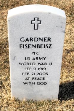
PFC Gardner Eisenbeisz
| Birth | : | 9 Sep 1919 Hosmer, Edmunds County, South Dakota, USA |
| Death | : | 21 Feb 2005 Mesa, Maricopa County, Arizona, USA |
| Burial | : | Black Hills National Cemetery, Sturgis, Meade County, USA |
| Coordinate | : | 44.3689003, -103.4753036 |
| Plot | : | I_743 |
| Inscription | : | PFC US ARMY WORLD WAR II |
| Description | : | Hosmer - Gardner Eisenbeisz, 85, Hosmer, died Monday, Feb. 21, following a cardiac event at his winter home in Apache Junction, Ariz. His funeral service will be 11 a.m., Tuesday, March 1, 2005 at St. John's Lutheran Church, Hosmer, with Pastor Robin Wanner-Schaunaman officiating. Burial will be 11:30 a.m. MT, Wednesday at the Black Hills National Cemetery, Sturgis, with the Sturgis Honor Guard providing Military Graveside Rites. Organist will be Wes Schaible and he and Joyce Heyne will sing. There will be a Military Honor Guard provided by the Adolph Forkel American Legion Post No. 189, Hosmer. Visitation will be... Read More |
frequently asked questions (FAQ):
-
Where is PFC Gardner Eisenbeisz's memorial?
PFC Gardner Eisenbeisz's memorial is located at: Black Hills National Cemetery, Sturgis, Meade County, USA.
-
When did PFC Gardner Eisenbeisz death?
PFC Gardner Eisenbeisz death on 21 Feb 2005 in Mesa, Maricopa County, Arizona, USA
-
Where are the coordinates of the PFC Gardner Eisenbeisz's memorial?
Latitude: 44.3689003
Longitude: -103.4753036
Family Members:
Parent
Siblings

Flowers:


Nearby Cemetories:
1. Black Hills National Cemetery
Sturgis, Meade County, USA
Coordinate: 44.3689003, -103.4753036
2. Curley Grimes Memorial Cemetery
Sturgis, Meade County, USA
Coordinate: 44.3764500, -103.4691300
3. Fort Meade National Cemetery
Sturgis, Meade County, USA
Coordinate: 44.4021988, -103.4757996
4. Bear Butte Cemetery
Sturgis, Meade County, USA
Coordinate: 44.4111595, -103.4947968
5. Saint Aloysius Cemetery
Sturgis, Meade County, USA
Coordinate: 44.4141340, -103.5193420
6. Pleasant Valley Cemetery
Tilford, Meade County, USA
Coordinate: 44.3192500, -103.3531160
7. Galena Cemetery
Galena, Lawrence County, USA
Coordinate: 44.3349220, -103.6438410
8. Crook City Cemetery
Crook City, Lawrence County, USA
Coordinate: 44.4432100, -103.6241500
9. Piedmont Cemetery
Piedmont, Meade County, USA
Coordinate: 44.2425780, -103.3871730
10. Oak Ridge Cemetery
Deadwood, Lawrence County, USA
Coordinate: 44.3891983, -103.6766968
11. Whitewood Cemetery
Whitewood, Lawrence County, USA
Coordinate: 44.4617820, -103.6330030
12. Roubaix Cemetery
Roubaix, Lawrence County, USA
Coordinate: 44.2789380, -103.6656600
13. Mount Moriah Cemetery
Deadwood, Lawrence County, USA
Coordinate: 44.3760986, -103.7253036
14. Saint Ambrose Cemetery
Deadwood, Lawrence County, USA
Coordinate: 44.3821983, -103.7266998
15. Nemo Cemetery
Nemo, Lawrence County, USA
Coordinate: 44.1872800, -103.5066410
16. Anderson Cemetery
Lawrence County, USA
Coordinate: 44.4747009, -103.6896973
17. South Lead Cemetery
Lead, Lawrence County, USA
Coordinate: 44.3478510, -103.7606260
18. Little Dane Cemetery
Saint Onge, Lawrence County, USA
Coordinate: 44.5252500, -103.6705540
19. Mountain Meadow Cemetery
Lawrence County, USA
Coordinate: 44.2038994, -103.6557999
20. West Lead Cemetery
Lead, Lawrence County, USA
Coordinate: 44.3484001, -103.7779999
21. Gate of Heaven Cemetery
Saint Onge, Lawrence County, USA
Coordinate: 44.5353000, -103.7237000
22. Terry Cemetery
Terry, Lawrence County, USA
Coordinate: 44.3344290, -103.8165110
23. Vale Cemetery
Vale, Butte County, USA
Coordinate: 44.6138992, -103.4052963
24. Holy Cross Cemetery
Englewood, Lawrence County, USA
Coordinate: 44.2818985, -103.8047028