Philip John Haller
| Birth | : | 16 Aug 1913 Webster County, Nebraska, USA |
| Death | : | 21 Nov 1970 Red Cloud, Webster County, Nebraska, USA |
| Burial | : | Callender Cemetery, Callender, Webster County, USA |
| Coordinate | : | 42.3693237, -94.2793427 |
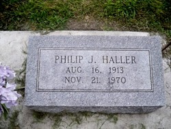
| Inscription | : | Philip J. Haller Aug. 16, 1913 Nov. 21, 1970 |
| Description | : | (Newspaper Obituary) Final Rites for Philip J. Haller Philip John Haller, 57, of 1221 11th Street, died Saturday while on a visit to Red Cloud. Funeral services were held at 9:30 a.m. Tuesday at St. Bonaventure Church, with Fr. Charles Potocki officiating, and burial in St. Bonaventure Cemetery. The body lay in state at McKown Funeral Home, where rosary was held. Pallbearers were Erv Weisler, Art Nyffler, Bud Siemek, Richard Haller, Craig Schwartz and Cliff Lambrecht. He was born August 16, 1913, at Bladen, the son of Frank J. and Teresa Novack Haller, Sr., and was educated at Bladen. Mr. Haller was married to Norma... Read More |
frequently asked questions (FAQ):
-
Where is Philip John Haller's memorial?
Philip John Haller's memorial is located at: Callender Cemetery, Callender, Webster County, USA.
-
When did Philip John Haller death?
Philip John Haller death on 21 Nov 1970 in Red Cloud, Webster County, Nebraska, USA
-
Where are the coordinates of the Philip John Haller's memorial?
Latitude: 42.3693237
Longitude: -94.2793427
Family Members:
Parent
Spouse
Siblings
Children
Flowers:
Nearby Cemetories:
1. Callender Cemetery
Callender, Webster County, USA
Coordinate: 42.3693237, -94.2793427
2. Vinje Cemetery
Callender, Webster County, USA
Coordinate: 42.3693237, -94.2797775
3. Saron Lutheran Cemetery
Callender, Webster County, USA
Coordinate: 42.3690720, -94.2780609
4. Our Saviour Cemetery
Callender, Webster County, USA
Coordinate: 42.3396988, -94.3153000
5. Fulton Township Cemetery
Moorland, Webster County, USA
Coordinate: 42.4272000, -94.3159000
6. Roland Township Cemetery
Slifer, Webster County, USA
Coordinate: 42.3685989, -94.3685989
7. Elkhorn Township Cemetery
Fort Dodge, Webster County, USA
Coordinate: 42.4276120, -94.2329690
8. Elkhorn Cemetery
Webster County, USA
Coordinate: 42.4277992, -94.2328033
9. Mizpah Cemetery
Webster County, USA
Coordinate: 42.3835983, -94.3707962
10. Our Lady of Good Counsel Cemetery
Moorland, Webster County, USA
Coordinate: 42.4427986, -94.3043976
11. Graceland Cemetery
Elkhorn Township, Webster County, USA
Coordinate: 42.4275017, -94.2127991
12. Fulton Lutheran Cemetery
Roelyn, Webster County, USA
Coordinate: 42.4263992, -94.3688965
13. Gowrie Township Cemetery
Gowrie, Webster County, USA
Coordinate: 42.2813988, -94.3043976
14. Webster County Home Cemetery
Fort Dodge, Webster County, USA
Coordinate: 42.4563710, -94.2181420
15. Lost Grove Cemetery
Harcourt, Webster County, USA
Coordinate: 42.2583008, -94.2331009
16. Otho Cemetery
Otho, Webster County, USA
Coordinate: 42.4025002, -94.1153030
17. Calvary Presbyterian Cemetery
Barnum, Webster County, USA
Coordinate: 42.4742810, -94.3835020
18. Cedar Cemetery
Rinard, Calhoun County, USA
Coordinate: 42.3456001, -94.4644012
19. Carpenter Cemetery
Webster County, USA
Coordinate: 42.5015907, -94.2166061
20. Saint Olafs Cemetery
Fort Dodge, Webster County, USA
Coordinate: 42.5017014, -94.2153015
21. Greenfield Cemetery
Knierim, Calhoun County, USA
Coordinate: 42.4495000, -94.4565000
22. Burns Cemetery
Webster County, USA
Coordinate: 42.5249970, -94.2759880
23. West Lawn Cemetery
Lehigh, Webster County, USA
Coordinate: 42.3616982, -94.0678024
24. Old Lizard Cemetery
Webster County, USA
Coordinate: 42.5249720, -94.3141340


