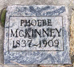
Phoebe Williams McKinney
| Birth | : | 15 Jun 1838 Sangamon County, Illinois, USA |
| Death | : | 24 Oct 1909 Ravalli County, Montana, USA |
| Burial | : | Floral Hills Memorial Gardens, Mount Clare, Harrison County, USA |
| Coordinate | : | 39.2155880, -80.2871940 |
frequently asked questions (FAQ):
-
Where is Phoebe Williams McKinney's memorial?
Phoebe Williams McKinney's memorial is located at: Floral Hills Memorial Gardens, Mount Clare, Harrison County, USA.
-
When did Phoebe Williams McKinney death?
Phoebe Williams McKinney death on 24 Oct 1909 in Ravalli County, Montana, USA
-
Where are the coordinates of the Phoebe Williams McKinney's memorial?
Latitude: 39.2155880
Longitude: -80.2871940
Family Members:
Parent
Siblings
Children
Flowers:

Left by Anonymous on 06 Dec 2009
Phoebe actually died in 1910, I have a letter and postmarked envelope she sent to DC asking for a pension, stating her husband William died from illness contracted while in the Civil War. Her husband William died in Washington County, Arkansas 1866.
Left by Anonymous on 16 Apr 2015
Nearby Cemetories:
1. Floral Hills Memorial Gardens
Mount Clare, Harrison County, USA
Coordinate: 39.2155880, -80.2871940
2. Haymond Cemetery
Quiet Dell, Harrison County, USA
Coordinate: 39.2132988, -80.2863998
3. Norman Cemetery
Quiet Dell, Harrison County, USA
Coordinate: 39.2083015, -80.2981033
4. Burns Cemetery
Harrison County, USA
Coordinate: 39.2127991, -80.3024979
5. Bond Cemetery
Harrison County, USA
Coordinate: 39.2280998, -80.3007965
6. Davisson Cemetery
Clarksburg, Harrison County, USA
Coordinate: 39.2374992, -80.2789001
7. Wolfe Cemetery
Quiet Dell, Harrison County, USA
Coordinate: 39.2043991, -80.3131027
8. Horeb Cemetery
Craigmoor, Harrison County, USA
Coordinate: 39.1927986, -80.2794037
9. Union Cemetery
Quiet Dell, Harrison County, USA
Coordinate: 39.2168999, -80.3349991
10. Trinity United Methodist Church Cemetery
Bridgeport, Harrison County, USA
Coordinate: 39.2264560, -80.2413880
11. Center Branch Cemetery
Clarksburg, Harrison County, USA
Coordinate: 39.2467003, -80.3155975
12. Hopewell Baptist Church Cemetery
Quiet Dell, Harrison County, USA
Coordinate: 39.1849870, -80.2553670
13. Mount Clare Odd Fellows Cemetery
Harrison County, USA
Coordinate: 39.2185540, -80.3387430
14. Adkinson Cemetery
Harrison County, USA
Coordinate: 39.2069016, -80.3396988
15. Radcliffe Cemetery
Harrison County, USA
Coordinate: 39.1800003, -80.2557983
16. Stouts Cemetery
Lost Creek, Harrison County, USA
Coordinate: 39.1903000, -80.3328018
17. Fortney Cemetery
Harrison County, USA
Coordinate: 39.2477989, -80.3313980
18. Old Batten Cemetery
Mount Clare, Harrison County, USA
Coordinate: 39.1693993, -80.3021164
19. Mount Zion Cemetery
Anmoore, Harrison County, USA
Coordinate: 39.2630997, -80.2810974
20. Nutter Cemetery
Nutter Fort, Harrison County, USA
Coordinate: 39.2596130, -80.3222400
21. Monroe Chapel Cemetery
Romines Mills, Harrison County, USA
Coordinate: 39.1668740, -80.2621030
22. Fraternal Memorial Park
Anmoore, Harrison County, USA
Coordinate: 39.2680790, -80.2811640
23. Pleasant Hill Cemetery
Lost Creek, Harrison County, USA
Coordinate: 39.1549988, -80.2774963
24. Seventh Day Baptist Church Cemetery
Lost Creek, Harrison County, USA
Coordinate: 39.1713982, -80.3419037


