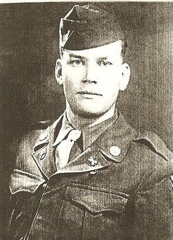
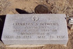
Pvt Charles Samuel “Charlie” Bowers
| Birth | : | 28 May 1923 Sugar City, Crowley County, Colorado, USA |
| Death | : | 25 May 1947 Crowley County, Colorado, USA |
| Burial | : | Sand Arroyo Cemetery, Crowley County, USA |
| Coordinate | : | 38.4658500, -103.5229300 |
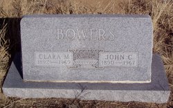
| Description | : | Charles Samuel Bowers was the fifth child of John C and Clara Devorak Bowers and was born at the family home near Sugar City, CO, on May 28, 1923. Charles attended school at nearby Sand Arroyo School and graduated from Sugar City, High School. He attended college for 2 years at Western State College in Gunnison, CO. where he majored in chemistry. He also worked in the molybdenum mine near Climax, CO during semesters. After the first two years of college, Charles stayed home to help at the family farm because all his older brothers were serving in the Army... Read More |
frequently asked questions (FAQ):
-
Where is Pvt Charles Samuel “Charlie” Bowers's memorial?
Pvt Charles Samuel “Charlie” Bowers's memorial is located at: Sand Arroyo Cemetery, Crowley County, USA.
-
When did Pvt Charles Samuel “Charlie” Bowers death?
Pvt Charles Samuel “Charlie” Bowers death on 25 May 1947 in Crowley County, Colorado, USA
-
Where are the coordinates of the Pvt Charles Samuel “Charlie” Bowers's memorial?
Latitude: 38.4658500
Longitude: -103.5229300
Family Members:
Parent
Siblings
Flowers:
Nearby Cemetories:
1. Sand Arroyo Cemetery
Crowley County, USA
Coordinate: 38.4658500, -103.5229300
2. Samuel Messersmith Grave
Karval, Lincoln County, USA
Coordinate: 38.6504290, -103.5208700
3. Arlington Cemetery
Arlington, Kiowa County, USA
Coordinate: 38.3232994, -103.3597031
4. Grandma Forgey Grave
Karval, Lincoln County, USA
Coordinate: 38.6511028, -103.6674361
5. Spring Hill Cemetery
Lincoln County, USA
Coordinate: 38.6458015, -103.7427979
6. Dudley Cemetery
Karval, Lincoln County, USA
Coordinate: 38.7134000, -103.6078000
7. Lakeview Cemetery
Sugar City, Crowley County, USA
Coordinate: 38.2332993, -103.6725006
8. Karval Cemetery
Karval, Lincoln County, USA
Coordinate: 38.7343000, -103.5361000
9. Haswell Cemetery
Haswell, Kiowa County, USA
Coordinate: 38.4472000, -103.1726000
10. Valley View Cemetery
Ordway, Crowley County, USA
Coordinate: 38.2546997, -103.7489014
11. Bucklen Cemetery
Lincoln County, USA
Coordinate: 38.7449989, -103.5355988
12. Kirkland Cemetery
Lincoln County, USA
Coordinate: 38.6389200, -103.8521700
13. East Holbrook Mennonite Cemetery
Cheraw, Otero County, USA
Coordinate: 38.1101837, -103.4729767
14. Rube Cemetery
Lincoln County, USA
Coordinate: 38.6683006, -103.9242020
15. Holbrook Cemetery
Otero County, USA
Coordinate: 38.0842018, -103.5432968
16. Liberty Bell Cemetery
Karval, Lincoln County, USA
Coordinate: 38.7799887, -103.8138296
17. Galatea Cemetery
Galatea, Kiowa County, USA
Coordinate: 38.5134190, -103.0066970
18. Bents Old Fort Cemetery
La Junta, Otero County, USA
Coordinate: 38.0416000, -103.4297000
19. Saint Paul’s Lutheran Cemetery
Otero County, USA
Coordinate: 38.0342000, -103.4542000
20. Hillcrest Cemetery
Rocky Ford, Otero County, USA
Coordinate: 38.0388985, -103.7071991
21. Valley View Cemetery
Rocky Ford, Otero County, USA
Coordinate: 38.0388985, -103.7093964
22. Olney Springs Cemetery
Olney Springs, Crowley County, USA
Coordinate: 38.1472282, -103.9310684
23. Manzanola Mountainview Cemetery
Manzanola, Otero County, USA
Coordinate: 38.0900002, -103.8764038
24. Fairview Cemetery
La Junta, Otero County, USA
Coordinate: 37.9873000, -103.5607000

