
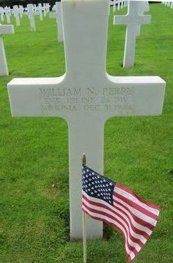
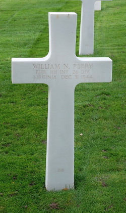
Pvt William Norman Perry
| Birth | : | 5 Aug 1914 Fredericksburg City, Virginia, USA |
| Death | : | 31 Dec 1944 Luxembourg |
| Burial | : | Luxembourg American Cemetery and Memorial, Hamm, Canton de Luxembourg, Luxembourg |
| Coordinate | : | 49.6114300, 6.1857600 |
| Plot | : | Plot D Row 13 Grave 24 |
| Description | : | Private, 101st Infantry Regiment, 26th Infantry Division, U.S. Army, World War II Service #33882598 Purple Heart, Combat Infantryman Badge, American Campaign Medal & World War II Victory Medal The Battle of the Bulge (December 16, 1944 – January 25, 1945) was the last major German offensive campaign of World War II. It was launched through the densely forested Ardennes region in Belgium, France, and Luxembourg. The surprise attack caught the Allied forces completely off guard. American forces bore the brunt of the attack. It was the largest and bloodiest battle fought by the United... Read More |
frequently asked questions (FAQ):
-
Where is Pvt William Norman Perry's memorial?
Pvt William Norman Perry's memorial is located at: Luxembourg American Cemetery and Memorial, Hamm, Canton de Luxembourg, Luxembourg.
-
When did Pvt William Norman Perry death?
Pvt William Norman Perry death on 31 Dec 1944 in Luxembourg
-
Where are the coordinates of the Pvt William Norman Perry's memorial?
Latitude: 49.6114300
Longitude: 6.1857600
Family Members:
Parent
Spouse
Siblings

Flowers:


Nearby Cemetories:
1. Luxembourg American Cemetery and Memorial
Hamm, Canton de Luxembourg, Luxembourg
Coordinate: 49.6114300, 6.1857600
2. Cimetiere de Hamm
Hamm, Canton de Luxembourg, Luxembourg
Coordinate: 49.6140023, 6.1774296
3. Sandweiler German War Cemetery
Sandweiler, Canton de Luxembourg, Luxembourg
Coordinate: 49.6093200, 6.2050010
4. Cimetière Malakoff
Canton de Luxembourg, Luxembourg
Coordinate: 49.6171600, 6.1445300
5. Cathedral of Our Lady
Luxembourg, Canton de Luxembourg, Luxembourg
Coordinate: 49.6095350, 6.1315830
6. Cimetière des Bons Malades
Canton de Luxembourg, Luxembourg
Coordinate: 49.6208310, 6.1328820
7. Cimetière de Notre Dame
Canton de Luxembourg, Luxembourg
Coordinate: 49.6156600, 6.1204700
8. Hollerich Communal Cemetery
Canton de Luxembourg, Luxembourg
Coordinate: 49.5990010, 6.1140530
9. Cimetiere de Merl
Luxembourg, Canton de Luxembourg, Luxembourg
Coordinate: 49.6123400, 6.0975700
10. Strassen
Strassen, Canton de Luxembourg, Luxembourg
Coordinate: 49.6175120, 6.0700370
11. Saints-Pierre-et-Paul
Bertrange, Canton de Luxembourg, Luxembourg
Coordinate: 49.6109427, 6.0577169
12. Cimetière de Bridel
Bridel, Canton de Capellen, Luxembourg
Coordinate: 49.6555900, 6.0765800
13. Cimetière de Waldbredimus
Waldbredimus, Canton de Remich, Luxembourg
Coordinate: 49.5553071, 6.2833588
14. Cimetière de Dalheim
Dalheim, Canton de Remich, Luxembourg
Coordinate: 49.5414918, 6.2601705
15. Gonderange
Gonderange, Canton de Grevenmacher, Luxembourg
Coordinate: 49.6921080, 6.2475330
16. Cimeteière d'Aspelt
Aspelt, Canton d'Esch-sur-Alzette, Luxembourg
Coordinate: 49.5214779, 6.2229488
17. Kehlen
Kehlen, Canton de Capellen, Luxembourg
Coordinate: 49.6713150, 6.0443040
18. Ancien cimetière Altwies
Altwies, Canton de Remich, Luxembourg
Coordinate: 49.5109686, 6.2546205
19. Gostingen Cemetery
Gostingen, Canton de Grevenmacher, Luxembourg
Coordinate: 49.6228330, 6.3551590
20. Mamer
Mamer, Canton de Capellen, Luxembourg
Coordinate: 49.6251120, 6.0138990
21. Junglinster Cemetery
Junglinster, Canton de Grevenmacher, Luxembourg
Coordinate: 49.7171047, 6.2465985
22. Stadtbredimus Cemetery
Stadtbredimus, Canton de Remich, Luxembourg
Coordinate: 49.5648900, 6.3624500
23. Ehnen Cemetery
Ehnen, Canton de Grevenmacher, Luxembourg
Coordinate: 49.6040420, 6.3864750
24. Cimetiere de Nospelt
Nospelt, Canton de Capellen, Luxembourg
Coordinate: 49.6739662, 6.0074374