
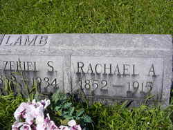
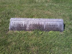
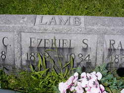
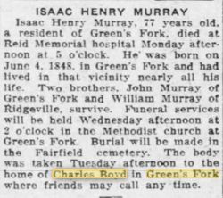
Rachel Adeline Murray Lamb
| Birth | : | 20 Jun 1852 Indiana, USA |
| Death | : | 1915 |
| Burial | : | Surteby Kyrkogård, Surteby, Marks kommun, Sweden |
| Coordinate | : | 57.4415428, 12.5166545 |
| Plot | : | 027 N 1/2 |
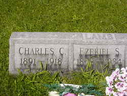
| Inscription | : | Wife of Ezekiel |
| Description | : | Marriage: 7 May 1881 in Washington (Greens Fork), Wayne County, Indiana |
frequently asked questions (FAQ):
-
Where is Rachel Adeline Murray Lamb's memorial?
Rachel Adeline Murray Lamb's memorial is located at: Surteby Kyrkogård, Surteby, Marks kommun, Sweden.
-
When did Rachel Adeline Murray Lamb death?
Rachel Adeline Murray Lamb death on 1915 in
-
Where are the coordinates of the Rachel Adeline Murray Lamb's memorial?
Latitude: 57.4415428
Longitude: 12.5166545
Family Members:
Parent
Spouse
Siblings

Children
Flowers:


Nearby Cemetories:
1. Surteby Kyrkogård
Surteby, Marks kommun, Sweden
Coordinate: 57.4415428, 12.5166545
2. Kattunga Kyrkogård
Kattunga, Marks kommun, Sweden
Coordinate: 57.4103879, 12.5360568
3. Berghems Kyrkogård
Berghem, Marks kommun, Sweden
Coordinate: 57.4618151, 12.5881601
4. Hajoms Kyrkogård
Hajom, Marks kommun, Sweden
Coordinate: 57.5039644, 12.5509172
5. Orby Kyrkogard
Örby, Marks kommun, Sweden
Coordinate: 57.4818140, 12.7005510
6. Idala kyrkogard
Idala, Kungsbacka kommun, Sweden
Coordinate: 57.3807920, 12.3236715
7. Fritsla gamla kyrkogård
Fritsla, Marks kommun, Sweden
Coordinate: 57.5574232, 12.7928255
8. Skephult kyrkogård
Skepphult, Marks kommun, Sweden
Coordinate: 57.5361110, 12.8811110
9. Bollebygd Cemetery
Bollebygd, Bollebygds kommun, Sweden
Coordinate: 57.6666679, 12.5500002
10. Onsala Kyrkogård
Kungsbacka kommun, Sweden
Coordinate: 57.4132398, 12.0226945
11. Kållered kyrka
Kallered, Mölndals kommun, Sweden
Coordinate: 57.6060222, 12.0556331
12. Rolfstorps Kyrkogård
Himle, Varbergs kommun, Sweden
Coordinate: 57.1437882, 12.4673786
13. Mårdaklevs Gamla Kyrkogård
Mardaklev, Svenljunga kommun, Sweden
Coordinate: 57.2589286, 12.9950129
14. Billdals kyrkogård
Billdal, Göteborgs kommun, Sweden
Coordinate: 57.5805229, 11.9794241
15. Kikås Cemetery
Mölndals kommun, Sweden
Coordinate: 57.6489610, 12.0472210
16. Svenska Kyrkan
Svenljunga, Svenljunga kommun, Sweden
Coordinate: 57.4951300, 13.1159100
17. Ljushults Kyrkogård
Borås, Borås kommun, Sweden
Coordinate: 57.6174795, 13.0432013
18. Sankt Sigfrids griftegård
Borås, Borås kommun, Sweden
Coordinate: 57.7049706, 12.9184835
19. Jonsereds griftegård
Jonsered, Partille kommun, Sweden
Coordinate: 57.7420182, 12.1762995
20. Sankta Birgittas griftegård
Borås, Borås kommun, Sweden
Coordinate: 57.7142538, 12.9332699
21. Kvastekulla Griftegård
Partille, Partille kommun, Sweden
Coordinate: 57.7337760, 12.1428190
22. Askims Södra kyrkogård
Hovas, Göteborgs kommun, Sweden
Coordinate: 57.6157113, 11.9416889
23. Sankt Ansgars griftegård
Borås, Borås kommun, Sweden
Coordinate: 57.7182057, 12.9351487
24. Lerums gamla kyrkogård
Lerums kommun, Sweden
Coordinate: 57.7757400, 12.2826970