Rachel Forward Hawley
| Birth | : | 3 Apr 1715 Belchertown, Hampshire County, Massachusetts, USA |
| Death | : | 29 Jun 1810 West Avon, Hartford County, Connecticut, USA |
| Burial | : | Union Cemetery, Pomeroy, Calhoun County, USA |
| Coordinate | : | 42.5539017, -94.6789017 |
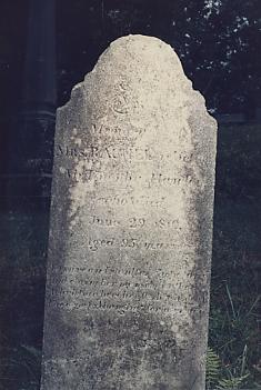
| Inscription | : | In Memory of MRS. RACHEL, relict of Mr. Timothy Hawley who died June 29, 1810. Aged 95 years. In sure and steadfast hope to rise And claim her mansion in the skies A Christian here her flesh la |
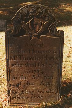
| Description | : | She was the daughter of Samuel Forward Jr.(1671-1738) & Deborah Moore(1676-1734). She married Timothy Hawley of E. Granby, Ct. in 1736. They had four children: Jesse, Rufus (married Deborah Kent in 1770), Abigail, Debora. |
frequently asked questions (FAQ):
-
Where is Rachel Forward Hawley's memorial?
Rachel Forward Hawley's memorial is located at: Union Cemetery, Pomeroy, Calhoun County, USA.
-
When did Rachel Forward Hawley death?
Rachel Forward Hawley death on 29 Jun 1810 in West Avon, Hartford County, Connecticut, USA
-
Where are the coordinates of the Rachel Forward Hawley's memorial?
Latitude: 42.5539017
Longitude: -94.6789017
Family Members:
Spouse
Children
Flowers:
Nearby Cemetories:
1. Union Cemetery
Pomeroy, Calhoun County, USA
Coordinate: 42.5539017, -94.6789017
2. Saint Marys Catholic Cemetery
Pomeroy, Calhoun County, USA
Coordinate: 42.5558014, -94.6889038
3. Memorial Park Cemetery
Calhoun County, USA
Coordinate: 42.5189018, -94.6194000
4. Swedish Cemetery
Manson, Calhoun County, USA
Coordinate: 42.5426295, -94.5992013
5. Swedish Mission Bethany Cemetery
Pocahontas County, USA
Coordinate: 42.6138992, -94.6774979
6. Evangelical Covenant Cemetery
Pomeroy, Calhoun County, USA
Coordinate: 42.6165720, -94.6803640
7. Elfsborg Lutheran Cemetery
Palmer, Pocahontas County, USA
Coordinate: 42.6169014, -94.6875000
8. Crown Hill Cemetery
Jolley, Calhoun County, USA
Coordinate: 42.4808006, -94.7360992
9. Palmer Cemetery
Palmer, Pocahontas County, USA
Coordinate: 42.6166992, -94.5894012
10. Saint Josephs Cemetery
Palmer, Pocahontas County, USA
Coordinate: 42.6342010, -94.6188965
11. Saint Paul Lutheran Cemetery
Palmer, Pocahontas County, USA
Coordinate: 42.6176000, -94.5893500
12. Saint Paul Lutheran Cemetery
Pocahontas County, USA
Coordinate: 42.5610000, -94.5392000
13. Grant Township Cemetery
Pocahontas, Pocahontas County, USA
Coordinate: 42.6571999, -94.6996994
14. Leith Cemetery
Manson, Calhoun County, USA
Coordinate: 42.4878006, -94.5667038
15. Saint Thomas Cemetery
Manson, Calhoun County, USA
Coordinate: 42.5208500, -94.5365000
16. Twin Lakes Cemetery
Jolley, Calhoun County, USA
Coordinate: 42.4427986, -94.6889038
17. Mount Zion Cemetery
Fonda, Pocahontas County, USA
Coordinate: 42.5821991, -94.8300018
18. Rose Hill Cemetery
Manson, Calhoun County, USA
Coordinate: 42.5228004, -94.5243988
19. Cedar Township Cemetery
Fonda, Pocahontas County, USA
Coordinate: 42.5810000, -94.8375000
20. Hope Cemetery
Manson, Calhoun County, USA
Coordinate: 42.4994011, -94.5199966
21. Saint Johns Lutheran Cemetery
Palmer, Pocahontas County, USA
Coordinate: 42.6268997, -94.5205994
22. Lizard Cemetery
Palmer, Pocahontas County, USA
Coordinate: 42.5875015, -94.4796982
23. Garfield Cemetery
Calhoun County, USA
Coordinate: 42.4275017, -94.7902985
24. Saint Columbkilles Cemetery
Varina, Pocahontas County, USA
Coordinate: 42.6467018, -94.8443985


