

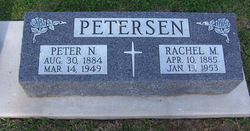
Rachel Matilda Jane Gillpatrick Petersen
| Birth | : | 10 Apr 1885 West Branch, Cedar County, Iowa, USA |
| Death | : | 13 Jan 1953 Iowa City, Johnson County, Iowa, USA |
| Burial | : | All Saints Anglican Church Cemetery, Bayswater, Lunenburg County, Canada |
| Coordinate | : | 44.4946430, -64.0785610 |
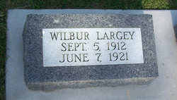
| Description | : | d/o Simon Peter & Medora Rosamond Baker Gillpatrick; w/o Peter Nikalie Petersen Mrs. Peter N Petersen, who was critically burned Friday, died at 5 o'clock Tuesday morning, at University hospital in Iowa City, where she had been taken from Atlantic Memorial hospital on Friday. Her age was 87. Mrs. Petersen lived with her son, Anton, on a farm a mile and a half north of Anita. Last Friday morning she lighted a stove accidentally with gasoline. It is thought she had become confused when filling her container for tanks of gasoline and kerosene were side by side near the house. She... Read More |
frequently asked questions (FAQ):
-
Where is Rachel Matilda Jane Gillpatrick Petersen's memorial?
Rachel Matilda Jane Gillpatrick Petersen's memorial is located at: All Saints Anglican Church Cemetery, Bayswater, Lunenburg County, Canada.
-
When did Rachel Matilda Jane Gillpatrick Petersen death?
Rachel Matilda Jane Gillpatrick Petersen death on 13 Jan 1953 in Iowa City, Johnson County, Iowa, USA
-
Where are the coordinates of the Rachel Matilda Jane Gillpatrick Petersen's memorial?
Latitude: 44.4946430
Longitude: -64.0785610
Family Members:
Parent

Spouse
Siblings

Children

Flowers:


Nearby Cemetories:
1. All Saints Anglican Church Cemetery
Bayswater, Lunenburg County, Canada
Coordinate: 44.4946430, -64.0785610
2. Boutilier Cemetery
Bayswater, Lunenburg County, Canada
Coordinate: 44.4934210, -64.0707980
3. All Saints First Cemetery
Bayswater, Lunenburg County, Canada
Coordinate: 44.4964500, -64.0673300
4. Swissair Crash Victims Mass Burial Site
Bayswater, Lunenburg County, Canada
Coordinate: 44.4995050, -64.0684890
5. Saint Barnabas Anglican Cemetery
Blandford, Lunenburg County, Canada
Coordinate: 44.4892500, -64.1025600
6. Old Gates Cemetery
Blandford, Lunenburg County, Canada
Coordinate: 44.4953500, -64.1073200
7. Old Zinck Cemetery
Blandford, Lunenburg County, Canada
Coordinate: 44.4838600, -64.1066200
8. Saint Barnabas Old Anglican Cemetery
Blandford, Lunenburg County, Canada
Coordinate: 44.4898900, -64.1152100
9. Baptist Cemetery
Upper Blandford, Lunenburg County, Canada
Coordinate: 44.5064460, -64.1187510
10. Gates Cemetery ll
Upper Blandford, Lunenburg County, Canada
Coordinate: 44.5149300, -64.1215900
11. Gates Cemetery Upper Blandford
Upper Blandford, Lunenburg County, Canada
Coordinate: 44.5198400, -64.1165600
12. Little Tancook Island Cemetery
Little Tancook, Lunenburg County, Canada
Coordinate: 44.4715600, -64.1366500
13. St. Cuthbert's Old Anglican Cemetery
Northwest Cove, Lunenburg County, Canada
Coordinate: 44.5295700, -64.0259000
14. Big Tancook Island Cemetery
Lunenburg County, Canada
Coordinate: 44.4584000, -64.1735200
15. Saint George's Cemetery
East River Point, Lunenburg County, Canada
Coordinate: 44.5704800, -64.1473500
16. Saint Mark's Anglican Cemetery
Mill Cove, Lunenburg County, Canada
Coordinate: 44.5863330, -64.0629720
17. Indian Harbour United Baptist Cemetery
Indian Harbour, Halifax County, Canada
Coordinate: 44.5284500, -63.9415500
18. Swiss Air Flight 111 Memorial Site
Peggys Cove, Halifax County, Canada
Coordinate: 44.5064800, -63.9332200
19. Saint James Anglican Church Cemetery
Fox Point, Lunenburg County, Canada
Coordinate: 44.6004900, -64.0618700
20. Saint James Cemetery Old
Fox Point, Lunenburg County, Canada
Coordinate: 44.6010700, -64.0601200
21. United Baptist Cemetery
Fox Point, Lunenburg County, Canada
Coordinate: 44.6021460, -64.0595830
22. Pine Hill Cemetery
Chester, Lunenburg County, Canada
Coordinate: 44.5428300, -64.2274500
23. Saint Augustine's Roman Catholic Cemetery
Chester, Lunenburg County, Canada
Coordinate: 44.5410500, -64.2415900
24. St. Stephen's Anglican Church Cemetery
Chester, Lunenburg County, Canada
Coordinate: 44.5418600, -64.2419200