
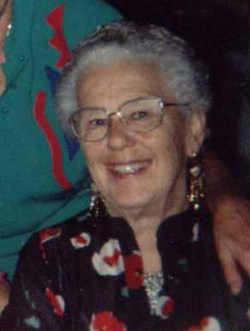

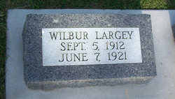
Thelma Clara Petersen Claussen Howell
| Birth | : | 24 Mar 1922 Audubon County, Iowa, USA |
| Death | : | 13 Mar 2002 Atlantic, Cass County, Iowa, USA |
| Burial | : | Saint John's Catholic Cemetery, Escalon, San Joaquin County, USA |
| Coordinate | : | 37.7994537, -121.0705185 |
| Description | : | Thelma was born at home in Audubon Co IA where she attended her first 1.5 years of school. The family moved to Cass Co where she attended school through the 8th grade. She married Charles Sorensen in July 1940, but the marriage only lasted 3 months. On Feb 1 1944, she married William Claussen. They moved to a farm in Adair on March 1 1944. In October of 1944, they moved to the family home in Anita. They had 4 children, Herm (1945), Frank (1947), Olinda (1950) and Bill (1952). After William became... Read More |
frequently asked questions (FAQ):
-
Where is Thelma Clara Petersen Claussen Howell's memorial?
Thelma Clara Petersen Claussen Howell's memorial is located at: Saint John's Catholic Cemetery, Escalon, San Joaquin County, USA.
-
When did Thelma Clara Petersen Claussen Howell death?
Thelma Clara Petersen Claussen Howell death on 13 Mar 2002 in Atlantic, Cass County, Iowa, USA
-
Where are the coordinates of the Thelma Clara Petersen Claussen Howell's memorial?
Latitude: 37.7994537
Longitude: -121.0705185
Family Members:
Parent

Spouse
Siblings
Children

Flowers:


Nearby Cemetories:
1. Saint John's Catholic Cemetery
Escalon, San Joaquin County, USA
Coordinate: 37.7994537, -121.0705185
2. Atlanta Cemetery
Five Corners, San Joaquin County, USA
Coordinate: 37.8270035, -121.1420135
3. Ripon Cemetery
Ripon, San Joaquin County, USA
Coordinate: 37.7420311, -121.1238708
4. Burwood Cemetery
Escalon, San Joaquin County, USA
Coordinate: 37.7616997, -120.9593964
5. Wood Colony Cemetery
Salida, Stanislaus County, USA
Coordinate: 37.6893730, -121.0682144
6. Valley Home Memorial Park
Oakdale, Stanislaus County, USA
Coordinate: 37.8275528, -120.9333267
7. Good Shepherd Catholic Cemetery
Modesto, Stanislaus County, USA
Coordinate: 37.6853130, -121.0672890
8. Collegeville Cemetery
Collegeville, San Joaquin County, USA
Coordinate: 37.9044800, -121.1466141
9. East Union Cemetery
Manteca, San Joaquin County, USA
Coordinate: 37.8114014, -121.2350006
10. Park View Cemetery
Manteca, San Joaquin County, USA
Coordinate: 37.8617249, -121.2238312
11. Highland View Memorial Gardens
Farmington, San Joaquin County, USA
Coordinate: 37.9242935, -121.0008621
12. Langworth Cemetery
Oakdale, Stanislaus County, USA
Coordinate: 37.7580986, -120.8957977
13. Old Brooks Farm Cemetery
Farmington, San Joaquin County, USA
Coordinate: 37.9175800, -120.9440300
14. Modesto County Cemetery
Modesto, Stanislaus County, USA
Coordinate: 37.6492400, -120.9813800
15. Acacia Memorial Park
Modesto, Stanislaus County, USA
Coordinate: 37.6481080, -120.9836610
16. Modesto Citizens Cemetery
Modesto, Stanislaus County, USA
Coordinate: 37.6472930, -120.9845570
17. Modesto Pioneer Cemetery
Modesto, Stanislaus County, USA
Coordinate: 37.6473350, -120.9829040
18. Saint Stanislaus Catholic Cemetery
Modesto, Stanislaus County, USA
Coordinate: 37.6473610, -120.9808440
19. Oaklawn Memorial Park
Oakdale, Stanislaus County, USA
Coordinate: 37.7711945, -120.8486862
20. Congregation Adas Yeshuran of Stockton Cemetery
French Camp, San Joaquin County, USA
Coordinate: 37.8784065, -121.2740784
21. Congregation of Ahavas Achim Cemetery
French Camp, San Joaquin County, USA
Coordinate: 37.8778419, -121.2753067
22. Saint Joseph Cemetery
Eugene, Stanislaus County, USA
Coordinate: 37.8941994, -120.8696976
23. Chinese Cemetery
French Camp, San Joaquin County, USA
Coordinate: 37.8819962, -121.2805862
24. Oakdale Citizens Cemetery
Oakdale, Stanislaus County, USA
Coordinate: 37.7624600, -120.8388800