

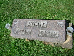
Ralph Edward Stout Sr.
| Birth | : | 4 May 1895 Fairfield, Jefferson County, Iowa, USA |
| Death | : | 28 Oct 1970 Fairfield, Jefferson County, Iowa, USA |
| Burial | : | Pisgah Cemetery, Atwood, Carroll County, USA |
| Coordinate | : | 35.9766998, -88.6622009 |
| Plot | : | 2nd.105 |
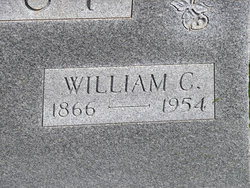
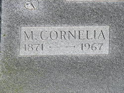
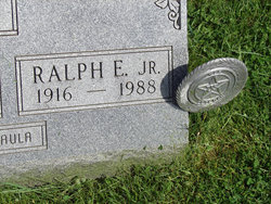
| Description | : | Ralph was the oldest of two children born to William Chesley and Mary Cornelia (Edwards) Stout. He married Mary Fern Carter in 1914 and they were the parents of on son: Ralph Edward Jr. |
frequently asked questions (FAQ):
-
Where is Ralph Edward Stout Sr.'s memorial?
Ralph Edward Stout Sr.'s memorial is located at: Pisgah Cemetery, Atwood, Carroll County, USA.
-
When did Ralph Edward Stout Sr. death?
Ralph Edward Stout Sr. death on 28 Oct 1970 in Fairfield, Jefferson County, Iowa, USA
-
Where are the coordinates of the Ralph Edward Stout Sr.'s memorial?
Latitude: 35.9766998
Longitude: -88.6622009
Family Members:
Parent
Spouse
Children
Flowers:


Nearby Cemetories:
1. Browning Family Cemetery
Atwood, Carroll County, USA
Coordinate: 35.9636700, -88.6662600
2. Keaton Cemetery
Carroll County, USA
Coordinate: 35.9611015, -88.6585999
3. Shaw Cemetery
Atwood, Carroll County, USA
Coordinate: 35.9786000, -88.6322200
4. Mount Olive Cemetery #2
Atwood, Carroll County, USA
Coordinate: 35.9648760, -88.6944160
5. Howse Cemetery
Howse, Carroll County, USA
Coordinate: 35.9499600, -88.6458800
6. Clark Family Cemetery
Atwood, Carroll County, USA
Coordinate: 35.9556900, -88.6333900
7. New Hope MBC Cemetery
Milan, Gibson County, USA
Coordinate: 35.9573000, -88.6994200
8. Jones Cemetery
McLemoresville, Carroll County, USA
Coordinate: 35.9791500, -88.6106400
9. Hurt Family Cemetery
Trezevant, Carroll County, USA
Coordinate: 35.9790900, -88.6105700
10. Leach Cemetery
Atwood, Carroll County, USA
Coordinate: 35.9359000, -88.6448800
11. Moore-Jones Cemetery
Carroll County, USA
Coordinate: 35.9543870, -88.6158080
12. Mount Ararat Cemetery
Trezevant, Carroll County, USA
Coordinate: 36.0140960, -88.6293450
13. Republican Grove Cemetery
Trezevant, Carroll County, USA
Coordinate: 36.0235150, -88.6545770
14. Poplar Springs Cemetery
Milan, Gibson County, USA
Coordinate: 35.9935989, -88.7172012
15. Trezevant Cemetery
Trezevant, Carroll County, USA
Coordinate: 36.0120400, -88.6195660
16. New Hope Cemetery
Atwood, Carroll County, USA
Coordinate: 35.9338799, -88.6960602
17. Clay Family Cemetery
Atwood, Carroll County, USA
Coordinate: 35.9597400, -88.6012900
18. Kitty Wright Cemetery
McLemoresville, Carroll County, USA
Coordinate: 35.9455850, -88.5982510
19. Oak Grove Cemetery
Trezevant, Carroll County, USA
Coordinate: 36.0350060, -88.6398990
20. Brooks Cemetery
Atwood, Carroll County, USA
Coordinate: 35.9430920, -88.5980040
21. Yancey Cemetery
Milan, Gibson County, USA
Coordinate: 35.9360060, -88.7243060
22. Bryant Cemetery
Milan, Gibson County, USA
Coordinate: 35.9202840, -88.7037580
23. Blanks Family Cemetery
Trezevant, Carroll County, USA
Coordinate: 36.0193000, -88.5999000
24. Shiloh Cemetery
Whitthorne, Carroll County, USA
Coordinate: 35.9108009, -88.6474991