
| Memorials | : | 0 |
| Location | : | Atwood, Carroll County, USA |
| Coordinate | : | 35.9430920, -88.5980040 |
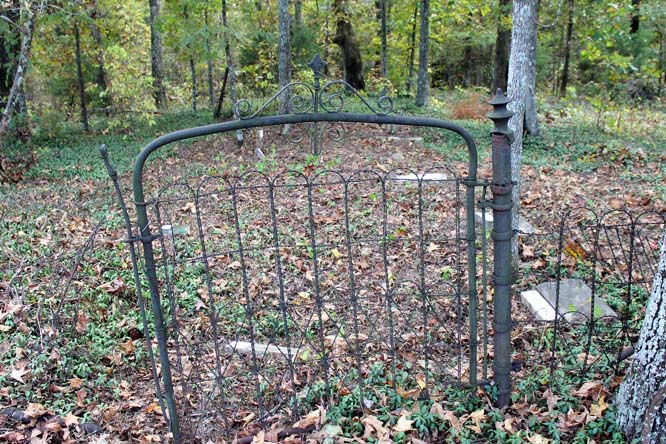
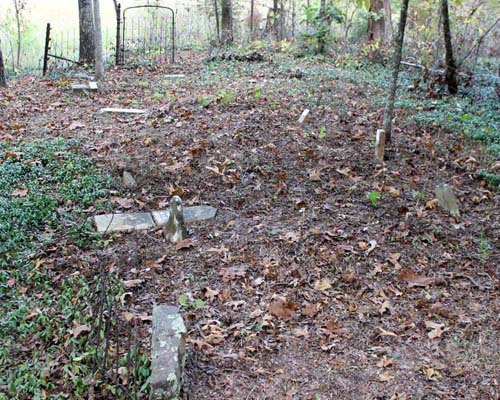
| Description | : | From intersection of Clay Farm Rd & US-79A, travel south on Clay Farm Rd. for 3.9 mi., turning south (right) onto Simmons Rd., [an unmarked farm road], for 0.2 mi. to the power-line cut in the trees. The cemetery is about 100 yards to the west (right) & near the power line stanchion, then south (left) into the woods. It is located within a old woven-wire fence & has a metal & wire gate. |
frequently asked questions (FAQ):
-
Where is Brooks Cemetery?
Brooks Cemetery is located at Simmons Ln Atwood, Carroll County ,Tennessee ,USA.
-
Brooks Cemetery cemetery's updated grave count on graveviews.com?
0 memorials
-
Where are the coordinates of the Brooks Cemetery?
Latitude: 35.9430920
Longitude: -88.5980040
Nearby Cemetories:
1. Kitty Wright Cemetery
McLemoresville, Carroll County, USA
Coordinate: 35.9455850, -88.5982510
2. Clay Family Cemetery
Atwood, Carroll County, USA
Coordinate: 35.9597400, -88.6012900
3. Moore-Jones Cemetery
Carroll County, USA
Coordinate: 35.9543870, -88.6158080
4. Carters Chapel Cemetery
Carroll County, USA
Coordinate: 35.9247017, -88.5727997
5. Little Grove Cemetery
Lavinia, Carroll County, USA
Coordinate: 35.9142220, -88.6096250
6. Clark Family Cemetery
Atwood, Carroll County, USA
Coordinate: 35.9556900, -88.6333900
7. New Reedy Creek Baptist Church Cemetery
McLemoresville, Carroll County, USA
Coordinate: 35.9693570, -88.5737870
8. Obion Chapel Church Cemetery
Cedar Grove, Carroll County, USA
Coordinate: 35.9198630, -88.5673110
9. Hurt Family Cemetery
Trezevant, Carroll County, USA
Coordinate: 35.9790900, -88.6105700
10. Jones Cemetery
McLemoresville, Carroll County, USA
Coordinate: 35.9791500, -88.6106400
11. Leach Cemetery
Atwood, Carroll County, USA
Coordinate: 35.9359000, -88.6448800
12. Howse Cemetery
Howse, Carroll County, USA
Coordinate: 35.9499600, -88.6458800
13. Cool Springs Cumberland Presbyterian Cemetery
Lavinia, Carroll County, USA
Coordinate: 35.9036470, -88.5789430
14. Shaw Cemetery
Atwood, Carroll County, USA
Coordinate: 35.9786000, -88.6322200
15. McLemoresville Cemetery
McLemoresville, Carroll County, USA
Coordinate: 35.9882400, -88.5788000
16. Reedy Creek Church Cemetery
McLemoresville, Carroll County, USA
Coordinate: 35.9888440, -88.5807860
17. Zion Church Cemetery
Lavinia, Carroll County, USA
Coordinate: 35.8947920, -88.5787710
18. Shiloh Cemetery
Whitthorne, Carroll County, USA
Coordinate: 35.9108009, -88.6474991
19. Keaton Cemetery
Carroll County, USA
Coordinate: 35.9611015, -88.6585999
20. Hopewell Baptist Church Cemetery
Hopewell, Carroll County, USA
Coordinate: 35.8977100, -88.6333600
21. Pearson Cemetery
Cedar Grove, Carroll County, USA
Coordinate: 35.9003660, -88.5531730
22. Price Cemetery
Trezevant, Carroll County, USA
Coordinate: 35.9534410, -88.5290640
23. Browning Family Cemetery
Atwood, Carroll County, USA
Coordinate: 35.9636700, -88.6662600
24. Pisgah Cemetery
Atwood, Carroll County, USA
Coordinate: 35.9766998, -88.6622009