
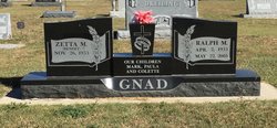
Ralph M. Gnad
| Birth | : | 2 Apr 1933 Ellis, Ellis County, Kansas, USA |
| Death | : | 22 May 2005 Hays, Ellis County, Kansas, USA |
| Burial | : | Calvary Cemetery, Omaha, Douglas County, USA |
| Coordinate | : | 41.2364006, -96.0294037 |
| Description | : | Ralph M. Gnad, 72, Hays, died Sunday, May 22, 2005, at Hays Medical Center. He was born April 2, 1933, in Ellis to Rudolph and Johanna (Augustine) Gnad. He married Zetta Benoit on Aug. 25, 1952, in Damar. He worked at Keller Furniture for many years. He was a member of the Immaculate Heart of Mary Catholic Church, Hays, and the Knights of Columbus and the Fourth Degree Knights of Columbus, both of Ellis. Survivors include his wife. of the home; a son, Mark Gnad, Gainesville, Fla.; two daughters, Paula Roberts, Lakin, and Colette Gnad, Hays; a brother,... Read More |
frequently asked questions (FAQ):
-
Where is Ralph M. Gnad's memorial?
Ralph M. Gnad's memorial is located at: Calvary Cemetery, Omaha, Douglas County, USA.
-
When did Ralph M. Gnad death?
Ralph M. Gnad death on 22 May 2005 in Hays, Ellis County, Kansas, USA
-
Where are the coordinates of the Ralph M. Gnad's memorial?
Latitude: 41.2364006
Longitude: -96.0294037
Family Members:
Parent

Siblings


Flowers:


Nearby Cemetories:
1. Calvary Cemetery
Omaha, Douglas County, USA
Coordinate: 41.2364006, -96.0294037
2. Evergreen Memorial Park Cemetery
Omaha, Douglas County, USA
Coordinate: 41.2393990, -96.0355988
3. Resurrection Cemetery
Omaha, Douglas County, USA
Coordinate: 41.2344208, -96.0365448
4. Ak-Sar-Ben Racetrack Grounds
Omaha, Douglas County, USA
Coordinate: 41.2414703, -96.0159607
5. Saint Andrews Episcopal Church Columbarium
Omaha, Douglas County, USA
Coordinate: 41.2492500, -96.0427500
6. Countryside Community Church Columbarium
Omaha, Douglas County, USA
Coordinate: 41.2483660, -96.0500270
7. Westlawn-Hillcrest Memorial Park
Omaha, Douglas County, USA
Coordinate: 41.2346992, -95.9966965
8. Bohemian Cemetery
Omaha, Douglas County, USA
Coordinate: 41.2388992, -95.9955978
9. Beth El Cemetery
Ralston, Douglas County, USA
Coordinate: 41.2117004, -96.0428009
10. Holy Sepulchre Cemetery
Omaha, Douglas County, USA
Coordinate: 41.2543983, -95.9875031
11. Douglas County Poor Farm Cemetery
Omaha, Douglas County, USA
Coordinate: 41.2437240, -95.9723480
12. Graceland Park Cemetery
Omaha, Douglas County, USA
Coordinate: 41.2113991, -95.9785995
13. Saint Mary Magdalene Cemetery
Omaha, Douglas County, USA
Coordinate: 41.2039420, -95.9850610
14. All Saints Episcopal Church Columbarium
Omaha, Douglas County, USA
Coordinate: 41.2785000, -96.0579000
15. First Central Congregational Columbarium
Omaha, Douglas County, USA
Coordinate: 41.2563456, -95.9658365
16. Nash Chapel Crypt
Omaha, Douglas County, USA
Coordinate: 41.2665090, -95.9721790
17. Saint Mary's Cemetery
Omaha, Douglas County, USA
Coordinate: 41.2042007, -95.9646988
18. Papillion Cemetery
Papillion, Sarpy County, USA
Coordinate: 41.1758003, -96.0410995
19. Portal Cemetery
Sarpy County, USA
Coordinate: 41.1838989, -96.0802994
20. Servants of Mary Cemetery
Omaha, Douglas County, USA
Coordinate: 41.3017170, -96.0258260
21. Prospect Hill Cemetery
Omaha, Douglas County, USA
Coordinate: 41.2780991, -95.9593964
22. Mount Hope Cemetery
Omaha, Douglas County, USA
Coordinate: 41.3041992, -96.0310974
23. Saint Johns Cemetery
Bellevue, Sarpy County, USA
Coordinate: 41.1864014, -95.9682999
24. Pleasant Hill Cemetery
Omaha, Douglas County, USA
Coordinate: 41.2558975, -96.1194687