
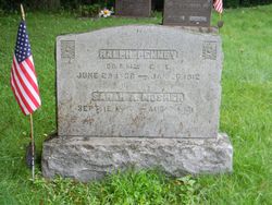
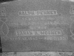
Ralph Penney
| Birth | : | 29 Jun 1836 Knox, Waldo County, Maine, USA |
| Death | : | 17 Jan 1913 Andover, Essex County, Massachusetts, USA |
| Burial | : | St Michael's Churchyard, Broome, South Norfolk District, England |
| Coordinate | : | 52.4860360, 1.4547410 |
| Description | : | NOTE: Dates on the gravestone do not match the dates on the Andover, Massachusetts, death register for 1913. h/o Sarah Mosher. Civil War Co B 14th Reg't ME Vol. Thanks to Kenneth Clark for the following: "Ralph Penney, aged 76 years, 6 months and 15 days, passed away at the Hood Farm in West Andover on Friday, January 17, 1913." (Based on the age at death, his birthdate would be July 2, 1936. Bev) "The deceased was a native of Knox, Maine, having been born there on June 26, 1836, the son of Robert and Delia [sic Debra]... Read More |
frequently asked questions (FAQ):
-
Where is Ralph Penney's memorial?
Ralph Penney's memorial is located at: St Michael's Churchyard, Broome, South Norfolk District, England.
-
When did Ralph Penney death?
Ralph Penney death on 17 Jan 1913 in Andover, Essex County, Massachusetts, USA
-
Where are the coordinates of the Ralph Penney's memorial?
Latitude: 52.4860360
Longitude: 1.4547410
Family Members:
Spouse

Children
Flowers:


Nearby Cemetories:
1. St Michael's Churchyard
Broome, South Norfolk District, England
Coordinate: 52.4860360, 1.4547410
2. Ditchingham Cemetery
Ditchingham, South Norfolk District, England
Coordinate: 52.4793614, 1.4307304
3. St. Mary's Churchyard
Ditchingham, South Norfolk District, England
Coordinate: 52.4776358, 1.4282946
4. St Mary's Churchyard
Ellingham, South Norfolk District, England
Coordinate: 52.4739393, 1.4827976
5. All Saints Churchyard
Kirby Cane, South Norfolk District, England
Coordinate: 52.4937500, 1.4952820
6. St. Peter's Churchyard
Hedenham, South Norfolk District, England
Coordinate: 52.4891780, 1.4041660
7. Holy Trinity Churchyard
Bungay, Waveney District, England
Coordinate: 52.4553310, 1.4399650
8. All Saints Churchyard
Mettingham, Waveney District, England
Coordinate: 52.4566620, 1.4764720
9. St. Mary's Churchyard and Priory
Bungay, Waveney District, England
Coordinate: 52.4555100, 1.4375800
10. St Edmunds RC Churchyard
Bungay, Waveney District, England
Coordinate: 52.4550570, 1.4381220
11. Emmanuel Church Cemetery
Bungay, Waveney District, England
Coordinate: 52.4526800, 1.4382410
12. Bungay Cemetery
Bungay, Waveney District, England
Coordinate: 52.4475475, 1.4444244
13. Wangford Union Workhouse Cemetery
Shipmeadow, Waveney District, England
Coordinate: 52.4540960, 1.4997050
14. St Margaret Churchyard
Hales, South Norfolk District, England
Coordinate: 52.5109380, 1.5110840
15. St. Bartholomew's Churchyard
Shipmeadow, Waveney District, England
Coordinate: 52.4557540, 1.5046408
16. All Saints Churchyard
Earsham, South Norfolk District, England
Coordinate: 52.4480480, 1.4212330
17. St Michael Churchyard
Geldeston, South Norfolk District, England
Coordinate: 52.4759460, 1.5246070
18. St Peter's Churchyard
Mundham, South Norfolk District, England
Coordinate: 52.5303890, 1.4260120
19. St Margaret and St Remigius Churchyard
Seething, South Norfolk District, England
Coordinate: 52.5303390, 1.4185000
20. Saint John Churchyard
Ilketshall St John, Waveney District, England
Coordinate: 52.4349960, 1.4707000
21. Holy Trinity Churchyard
Loddon, South Norfolk District, England
Coordinate: 52.5350430, 1.4832560
22. St Andrews Churchyard
Raveningham, South Norfolk District, England
Coordinate: 52.5126430, 1.5323570
23. Saint Andrews Churchyard
Bedingham, South Norfolk District, England
Coordinate: 52.4902500, 1.3643180
24. Holy Trinity Churchyard
Barsham, Waveney District, England
Coordinate: 52.4520000, 1.5263000