
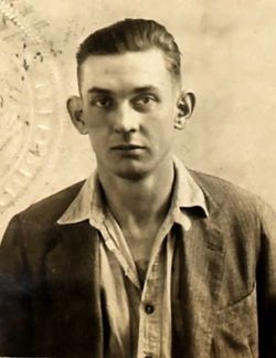

Ralph Squire More
| Birth | : | 6 Sep 1901 New York, USA |
| Death | : | 16 May 1964 Reno, Washoe County, Nevada, USA |
| Burial | : | Los Molinos Cemetery, Los Molinos, Tehama County, USA |
| Coordinate | : | 40.0475650, -122.1011820 |
| Plot | : | Section 4 |
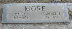
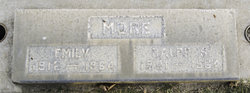
| Description | : | JMA# 45511 Ralph was raised at Spokane, Washington and Seattle, Washington where his father was a street railway motorman. The family relocated to Los Molinos about 1916. He was the son of Clarence More and Maude Tyler More. As a young boy, he sold newspapers on the streets of Seattle. As a young man, he served in the United States Army during World War I. Ralph was a miner at Grass Valley, California when he married to Marian Thelma Cole on 23 September 1939 at Reno, Nevada. They made their home first at Bridgeport, California where Ralph was a... Read More |
frequently asked questions (FAQ):
-
Where is Ralph Squire More's memorial?
Ralph Squire More's memorial is located at: Los Molinos Cemetery, Los Molinos, Tehama County, USA.
-
When did Ralph Squire More death?
Ralph Squire More death on 16 May 1964 in Reno, Washoe County, Nevada, USA
-
Where are the coordinates of the Ralph Squire More's memorial?
Latitude: 40.0475650
Longitude: -122.1011820
Family Members:
Parent
Spouse
Siblings
Flowers:


Nearby Cemetories:
1. Los Molinos Cemetery
Los Molinos, Tehama County, USA
Coordinate: 40.0475650, -122.1011820
2. Tehama Cemetery
Tehama, Tehama County, USA
Coordinate: 40.0233002, -122.1433029
3. Growney Ranch Family Cemetery
Red Bluff, Tehama County, USA
Coordinate: 40.1167300, -122.1952500
4. New Clairvaux Abbey Cemetery
Vina, Tehama County, USA
Coordinate: 39.9381450, -122.0641890
5. Vina Cemetery
Vina, Tehama County, USA
Coordinate: 39.9636440, -121.9957070
6. Sunset Hill Cemetery
Corning, Tehama County, USA
Coordinate: 39.9271600, -122.1586100
7. Oak Hill Cemetery
Red Bluff, Tehama County, USA
Coordinate: 40.1699982, -122.2433014
8. Red Bluff Memorial Chapel Mausoleum & Columbarium
Red Bluff, Tehama County, USA
Coordinate: 40.1717130, -122.2466860
9. Saint Mary's Cemetery
Red Bluff, Tehama County, USA
Coordinate: 40.1716995, -122.2521973
10. Kirkwood Cemetery
Corning, Tehama County, USA
Coordinate: 39.8624992, -122.1519012
11. Pine Creek Cemetery
Chico, Butte County, USA
Coordinate: 39.8617240, -121.9842480
12. Red Bank Cemetery
Red Bank, Tehama County, USA
Coordinate: 40.1036970, -122.4458540
13. Cameron-Davis Cemetery
Tehama County, USA
Coordinate: 40.2709800, -121.8778500
14. Orland Masonic Cemetery
Orland, Glenn County, USA
Coordinate: 39.7684760, -122.1943310
15. Elmore Cemetery
Flournoy, Tehama County, USA
Coordinate: 39.8642006, -122.4005966
16. Bragg Cemetery
Nord, Butte County, USA
Coordinate: 39.7750980, -121.9568170
17. Inks Creek Cemetery
Tehama County, USA
Coordinate: 40.3419800, -122.1297100
18. Graves Cemetery
Orland, Glenn County, USA
Coordinate: 39.7827988, -122.2930984
19. Cohasset Cemetery
Cohasset, Butte County, USA
Coordinate: 39.9124880, -121.7333220
20. Benner Family Cemetery
Tehama County, USA
Coordinate: 40.1826890, -121.7183500
21. Cottonwood Creek Ranch Cemetery
Cottonwood, Shasta County, USA
Coordinate: 40.3663100, -122.2598800
22. Paskenta Cemetery
Corning, Tehama County, USA
Coordinate: 39.9002991, -122.5089035
23. Orland Catholic Cemetery
Orland, Glenn County, USA
Coordinate: 39.7030983, -122.1393967
24. Orland IOOF Cemetery
Orland, Glenn County, USA
Coordinate: 39.7026000, -122.1401000