

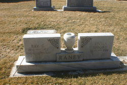
Ray C. Raney
| Birth | : | 18 Dec 1892 Elsie, Perkins County, Nebraska, USA |
| Death | : | 6 Jul 1973 Sutherland, Lincoln County, Nebraska, USA |
| Burial | : | East Montcalm Cemetery, Greenville, Montcalm County, USA |
| Coordinate | : | 43.2266998, -85.2510986 |
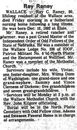
| Description | : | Buried July 9,1973 Lot 605 Space- 01 Ray C.Raney Dec 18,1892-July 6,1973 Ray C.Raney, 80, lifelong resident of the Wallace area, died Friday morning in a Sutherland nursing home following a long illness. He was born Dec 18,1892 in Elsie, Nebraska. Mr. Raney, a retired rancher and farmer was a past Grand Master of the Independent Order of Odd Fellows of the State of Nebraska. He was a member of the Wallace Lodge No.338 of IOOF, Patriot Militant No. 6 of North Platte and the encampment at Wellfleet. Mr.Raney was a member of the Methodist Church. Survivors include his wife, Vivian; one foster-daughter, Mrs.Wilma Dunn... Read More |
frequently asked questions (FAQ):
-
Where is Ray C. Raney's memorial?
Ray C. Raney's memorial is located at: East Montcalm Cemetery, Greenville, Montcalm County, USA.
-
When did Ray C. Raney death?
Ray C. Raney death on 6 Jul 1973 in Sutherland, Lincoln County, Nebraska, USA
-
Where are the coordinates of the Ray C. Raney's memorial?
Latitude: 43.2266998
Longitude: -85.2510986
Family Members:
Parent
Spouse
Siblings

Flowers:


Nearby Cemetories:
1. East Montcalm Cemetery
Greenville, Montcalm County, USA
Coordinate: 43.2266998, -85.2510986
2. Bethania Cemetery
Gowen, Montcalm County, USA
Coordinate: 43.2333540, -85.2716950
3. Monroe Cemetery
Greenville, Montcalm County, USA
Coordinate: 43.2338982, -85.2716980
4. Saint Charles Catholic Cemetery
Greenville, Montcalm County, USA
Coordinate: 43.1889000, -85.2733002
5. Wolverton Plains Cemetery
Greenville, Montcalm County, USA
Coordinate: 43.2094002, -85.3024979
6. First Congregational Chapel Columbarium
Greenville, Montcalm County, USA
Coordinate: 43.1787370, -85.2527370
7. First United Methodist Church Columbarium
Greenville, Montcalm County, USA
Coordinate: 43.1787690, -85.2550860
8. Saint Paul Episcopal Church Columbarium
Greenville, Montcalm County, USA
Coordinate: 43.1785420, -85.2517710
9. South Sidney Cemetery
Sidney, Montcalm County, USA
Coordinate: 43.2208050, -85.1826570
10. Little Denmark Cemetery
Gowen, Montcalm County, USA
Coordinate: 43.2677994, -85.3013992
11. Forest Home Cemetery
Greenville, Montcalm County, USA
Coordinate: 43.1638985, -85.2613983
12. Eureka Township Cemetery
Greenville, Montcalm County, USA
Coordinate: 43.1622500, -85.2603000
13. Potters Field
Greenville, Montcalm County, USA
Coordinate: 43.1922500, -85.1628000
14. Spencer Mills Cemetery
Spencer Township, Kent County, USA
Coordinate: 43.2209920, -85.3556680
15. Amish Greenville Church District Cemetery
Stanton, Montcalm County, USA
Coordinate: 43.3060570, -85.2311130
16. North Sidney Cemetery
Sidney, Montcalm County, USA
Coordinate: 43.2658600, -85.1533500
17. Sidney Township Cemetery
Sidney, Montcalm County, USA
Coordinate: 43.2503100, -85.1369600
18. Riverside Cemetery
Langston, Montcalm County, USA
Coordinate: 43.3136400, -85.2400300
19. Fairplains Cemetery
Greenville, Montcalm County, USA
Coordinate: 43.1561400, -85.1722400
20. Oakfield Cemetery
Rockford, Kent County, USA
Coordinate: 43.1693993, -85.3814011
21. Rest Haven Memory Gardens
Belding, Ionia County, USA
Coordinate: 43.1138992, -85.2613983
22. Trufant Cemetery
Maple Valley Township, Montcalm County, USA
Coordinate: 43.3083000, -85.3653030
23. Saint Margarets Catholic Cemetery
Spencer Township, Kent County, USA
Coordinate: 43.2063890, -85.4169440
24. Ashley Cemetery
Grattan Township, Kent County, USA
Coordinate: 43.1149560, -85.3329510