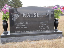
Ray Vinton “John” Kaiser
| Birth | : | 3 Jul 1917 Nebraska, USA |
| Death | : | 13 Oct 1997 Adams, Gage County, Nebraska, USA |
| Burial | : | Highland Cemetery, Adams, Gage County, USA |
| Coordinate | : | 40.4580994, -96.5196991 |
| Plot | : | Section 13 |
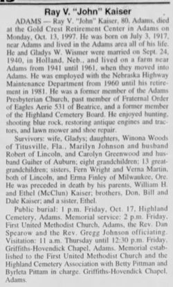
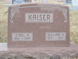
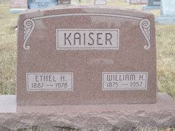
| Description | : | Son of William & Ethel McClun Kaiser. He is survived by three daughters, 8 grandchildren, 13 great-grandchildren, and three sisters. He was preceded in death by his parents, three brothers, and one sister. From funeral records courtesy of Griffiths-Hovendick Chapel, Beatrice, Nebraska. |
frequently asked questions (FAQ):
-
Where is Ray Vinton “John” Kaiser's memorial?
Ray Vinton “John” Kaiser's memorial is located at: Highland Cemetery, Adams, Gage County, USA.
-
When did Ray Vinton “John” Kaiser death?
Ray Vinton “John” Kaiser death on 13 Oct 1997 in Adams, Gage County, Nebraska, USA
-
Where are the coordinates of the Ray Vinton “John” Kaiser's memorial?
Latitude: 40.4580994
Longitude: -96.5196991
Family Members:
Parent
Spouse
Siblings
Flowers:
Nearby Cemetories:
1. Highland Cemetery
Adams, Gage County, USA
Coordinate: 40.4580994, -96.5196991
2. Hooker Cemetery
Adams, Gage County, USA
Coordinate: 40.4207993, -96.4732971
3. Grandview Cemetery
Gage County, USA
Coordinate: 40.4617004, -96.6091995
4. Granite Hill Cemetery
Johnson County, USA
Coordinate: 40.4180984, -96.4417038
5. Immanuel Cemetery
Sterling, Johnson County, USA
Coordinate: 40.4692001, -96.4253006
6. Latrobe Cemetery
Sterling, Johnson County, USA
Coordinate: 40.5151000, -96.4557000
7. Weber Cemetery
Sterling, Johnson County, USA
Coordinate: 40.4581000, -96.4177000
8. Saint Johns Lutheran Cemetery
Cortland, Gage County, USA
Coordinate: 40.5078300, -96.6252700
9. Firth Cemetery
Firth, Lancaster County, USA
Coordinate: 40.5250015, -96.6085968
10. Pella Cemetery
Panama, Lancaster County, USA
Coordinate: 40.5555992, -96.5014038
11. Saint John North Lutheran Cemetery
Sterling, Johnson County, USA
Coordinate: 40.4689500, -96.3878500
12. Sunnyside Cemetery
Cortland, Gage County, USA
Coordinate: 40.4799200, -96.6511800
13. South Saint John Lutheran Cemetery
Sterling, Johnson County, USA
Coordinate: 40.4355500, -96.3858000
14. Dietz Cemetery
Firth, Lancaster County, USA
Coordinate: 40.5449982, -96.6286011
15. Sterling Cemetery
Sterling, Johnson County, USA
Coordinate: 40.4585991, -96.3582993
16. Panama Cemetery
Panama, Lancaster County, USA
Coordinate: 40.5821991, -96.5255966
17. Zion Evangelical Lutheran Cemetery
Pickrell, Gage County, USA
Coordinate: 40.3456001, -96.6147003
18. Christ Lutheran Church Cemetery
Pickrell, Gage County, USA
Coordinate: 40.4079410, -96.6848370
19. Saint James Cemetery
Cortland, Gage County, USA
Coordinate: 40.4886050, -96.7036050
20. Cortland Cemetery
Cortland, Gage County, USA
Coordinate: 40.4879200, -96.7041250
21. Crab Orchard Cemetery
Crab Orchard, Johnson County, USA
Coordinate: 40.3274994, -96.4366989
22. Solon Cemetery
Otoe County, USA
Coordinate: 40.5917015, -96.4436035
23. Holland Cemetery
Holland, Lancaster County, USA
Coordinate: 40.5957985, -96.5997009
24. Rosehill Cemetery
Douglas, Otoe County, USA
Coordinate: 40.5845940, -96.3867900

