
| Birth | : | 4 Mar 1913 Selma, Van Buren County, Iowa, USA |
| Death | : | 29 Dec 1993 Fairfield, Jefferson County, Iowa, USA |
| Burial | : | Mount Moriah Cemetery, Douds, Van Buren County, USA |
| Coordinate | : | 40.8710000, -92.0860000 |
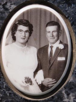
| Description | : | Rayburn J. Tedrow (1913-1993) was the son of Grace Camblin & Joseph Brown Tedrow. He was married to Vermith Fae Ferrel on 25 March 1933 at Jefferson Co., IA. They had two sons and later divorced. On 14 September 1940 at Memphis, MO Rayburn married Naomi Mae Bailey. They had two children. Rayburn was a farmer in Van Buren County and member of the Mount Zion United Methodist Church. |
frequently asked questions (FAQ):
-
Where is Rayburn Joseph Tedrow's memorial?
Rayburn Joseph Tedrow's memorial is located at: Mount Moriah Cemetery, Douds, Van Buren County, USA.
-
When did Rayburn Joseph Tedrow death?
Rayburn Joseph Tedrow death on 29 Dec 1993 in Fairfield, Jefferson County, Iowa, USA
-
Where are the coordinates of the Rayburn Joseph Tedrow's memorial?
Latitude: 40.8710000
Longitude: -92.0860000
Family Members:
Parent

Spouse
Siblings
Children
Flowers:


Nearby Cemetories:
1. Mount Moriah Cemetery
Douds, Van Buren County, USA
Coordinate: 40.8710000, -92.0860000
2. Zion Lutheran Cemetery
Douds, Van Buren County, USA
Coordinate: 40.8563000, -92.0664000
3. Boyer Family Cemetery
Leando, Van Buren County, USA
Coordinate: 40.8333560, -92.1112885
4. Leando Cemetery
Douds, Van Buren County, USA
Coordinate: 40.8269005, -92.0883026
5. Winsell Cemetery
Fairfield, Jefferson County, USA
Coordinate: 40.9067001, -92.1247025
6. Passmore Cemetery
Van Buren County, USA
Coordinate: 40.8608017, -92.1549988
7. White Chapel Cemetery
Birmingham, Van Buren County, USA
Coordinate: 40.8417015, -92.0203018
8. Iowaville Cemetery
Selma, Van Buren County, USA
Coordinate: 40.8861008, -92.1628036
9. Bethel Cemetery
Birmingham, Van Buren County, USA
Coordinate: 40.8967018, -92.0056000
10. Fell Cemetery
Libertyville, Jefferson County, USA
Coordinate: 40.9375000, -92.0772018
11. Hem Cemetery
Davis County, USA
Coordinate: 40.8389015, -92.1785965
12. Rominger Cemetery
Batavia, Jefferson County, USA
Coordinate: 40.9379000, -92.1503000
13. Roush Cemetery
Chequest Township, Van Buren County, USA
Coordinate: 40.7872009, -92.0755997
14. Chief Black Hawk Burial Site
Floris, Davis County, USA
Coordinate: 40.8852780, -92.1972220
15. Hissem Cemetery
Selma, Van Buren County, USA
Coordinate: 40.8030784, -92.1587902
16. Cumberland Cemetery
Jefferson County, USA
Coordinate: 40.9248000, -91.9903000
17. Mathias Cemetery
Van Buren County, USA
Coordinate: 40.8031000, -92.1681000
18. Thompson Cemetery
Jefferson County, USA
Coordinate: 40.9155998, -91.9772034
19. Jefferson County Poor Farm Cemetery
Libertyville, Jefferson County, USA
Coordinate: 40.9416900, -91.9996200
20. Heidlebaugh Cemetery
Davis County, USA
Coordinate: 40.8165800, -92.1933500
21. Valentine Cemetery
Keosauqua, Van Buren County, USA
Coordinate: 40.7743988, -92.0460968
22. Clinkinbeard Family Cemetery
Libertyville, Jefferson County, USA
Coordinate: 40.9083300, -91.9583300
23. Chequest Miller Cemetery
Van Buren County, USA
Coordinate: 40.7847200, -92.1641300
24. Spencer Farm Cemetery
Leando, Van Buren County, USA
Coordinate: 40.7847200, -92.1641300