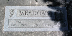
Raymond Earl Meadows
| Birth | : | 30 Jan 1903 Claremore, Rogers County, Oklahoma, USA |
| Death | : | 16 Mar 1993 Plains, Sanders County, Montana, USA |
| Burial | : | Lakeview Cemetery, Lakeview, Montcalm County, USA |
| Coordinate | : | 43.4467010, -85.2739029 |
| Description | : | Raymond Earl Meadows Memorial services for Raymond Earl Meadows, 90, longtime Sanders County resident, are scheduled for 2 p.m., Friday, March 19, at the Whitepine Grange Hall with Pastor Mary Harker officiating. He died Tuesday, March 16, 1993 of pheumonia complications at Clark Fork Valley Hospital, Plains. He was born January 30, 1903, in Claremore, Oklahoma, the son of William and Sarah Meadows. His family settled in the Noxon area after short stays in Kansas and Wyoming. He attended schools at Noxon and Thompson Falls. He enrolled in a business course at Kinman Business... Read More |
frequently asked questions (FAQ):
-
Where is Raymond Earl Meadows's memorial?
Raymond Earl Meadows's memorial is located at: Lakeview Cemetery, Lakeview, Montcalm County, USA.
-
When did Raymond Earl Meadows death?
Raymond Earl Meadows death on 16 Mar 1993 in Plains, Sanders County, Montana, USA
-
Where are the coordinates of the Raymond Earl Meadows's memorial?
Latitude: 43.4467010
Longitude: -85.2739029
Family Members:
Parent
Spouse
Siblings
Flowers:
Nearby Cemetories:
1. Lakeview Cemetery
Lakeview, Montcalm County, USA
Coordinate: 43.4467010, -85.2739029
2. Cato Cemetery
Lakeview, Montcalm County, USA
Coordinate: 43.4171982, -85.2472000
3. Dickerson-Whitsell Cemetery
Lakeview, Montcalm County, USA
Coordinate: 43.4533005, -85.3227997
4. Rustford Cemetery
Morley, Mecosta County, USA
Coordinate: 43.4972916, -85.3432999
5. Hinton Cemetery
Hinton Township, Mecosta County, USA
Coordinate: 43.5219002, -85.2643967
6. Boyd Cemetery
Morley, Mecosta County, USA
Coordinate: 43.4796982, -85.3818970
7. West Pine Cemetery
Coral, Montcalm County, USA
Coordinate: 43.3669014, -85.3227997
8. Hillcrest Cemetery
Six Lakes, Montcalm County, USA
Coordinate: 43.4432983, -85.1468964
9. Amble Cemetery
Amble, Montcalm County, USA
Coordinate: 43.4352989, -85.4024963
10. Altona Cemetery
Altona, Mecosta County, USA
Coordinate: 43.5393982, -85.3003006
11. Evergreen Cemetery
Six Lakes, Montcalm County, USA
Coordinate: 43.4017000, -85.1353000
12. Saint Apollonia Cemetery
Morley, Mecosta County, USA
Coordinate: 43.4907990, -85.4278030
13. Coady Cemetery
Maple Valley Township, Montcalm County, USA
Coordinate: 43.3540520, -85.3825890
14. Coral Cemetery
Coral, Montcalm County, USA
Coordinate: 43.3671989, -85.4060974
15. Higbee Cemetery
Stanwood, Mecosta County, USA
Coordinate: 43.5394707, -85.3921890
16. Morton Township Cemetery
Mecosta, Mecosta County, USA
Coordinate: 43.5710983, -85.2249985
17. Hillside Entrican Cemetery
Entrican, Montcalm County, USA
Coordinate: 43.3539009, -85.1446991
18. Maple Valley Cemetery
Maple Valley Township, Montcalm County, USA
Coordinate: 43.3358002, -85.3724976
19. Holt Cemetery
Morley, Mecosta County, USA
Coordinate: 43.5130997, -85.4332962
20. Riverside Cemetery
Langston, Montcalm County, USA
Coordinate: 43.3136400, -85.2400300
21. Quigley Cemetery
Deerfield Township, Mecosta County, USA
Coordinate: 43.5536003, -85.3930969
22. Aetna Township Cemetery
Morley, Mecosta County, USA
Coordinate: 43.4906006, -85.4597015
23. Amish Greenville Church District Cemetery
Stanton, Montcalm County, USA
Coordinate: 43.3060570, -85.2311130
24. Decker Cemetery
Millbrook, Mecosta County, USA
Coordinate: 43.5269012, -85.1035995


