
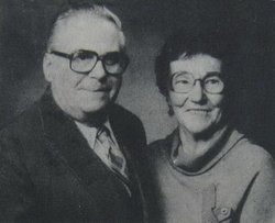

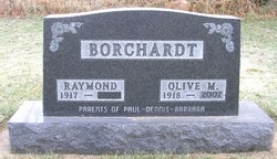
Raymond Edward Borchardt
| Birth | : | 16 Nov 1917 Grafton, Worth County, Iowa, USA |
| Death | : | 25 Jul 2011 Mason City, Cerro Gordo County, Iowa, USA |
| Burial | : | Calvary Cemetery, Osage, Mitchell County, USA |
| Coordinate | : | 43.2238998, -92.8300018 |
| Description | : | Raymond E. Borchardt (Died July 25, 2011) Raymond E. Borchardt, age 93, of Mason City and formerly of Osage, died Monday, July 25, 2011, at the I.O.O.F. Home in Mason City, Iowa. Funeral services will be held at 2:00 p.m. Friday, July 29, 2011, at St. John's Lutheran Church, 1921 317th Street, south of Osage, with Pastor Byron Northwick and Pastor Edward Bard, Chaplain at Hospice of North Iowa, officiating. Burial will be in the Calvary Cemetery. Visitation is from 4:00 to 7:00 p.m. Thursday at the Champion-Bucheit Funeral Home in Osage. |
frequently asked questions (FAQ):
-
Where is Raymond Edward Borchardt's memorial?
Raymond Edward Borchardt's memorial is located at: Calvary Cemetery, Osage, Mitchell County, USA.
-
When did Raymond Edward Borchardt death?
Raymond Edward Borchardt death on 25 Jul 2011 in Mason City, Cerro Gordo County, Iowa, USA
-
Where are the coordinates of the Raymond Edward Borchardt's memorial?
Latitude: 43.2238998
Longitude: -92.8300018
Family Members:
Parent

Spouse
Siblings
Flowers:


Nearby Cemetories:
1. Calvary Cemetery
Osage, Mitchell County, USA
Coordinate: 43.2238998, -92.8300018
2. Tucker Cemetery
Osage, Mitchell County, USA
Coordinate: 43.2494011, -92.8319016
3. Dudley Cemetery
Dudley (historical), Mitchell County, USA
Coordinate: 43.2252998, -92.8743973
4. Orchard Cemetery
Orchard, Mitchell County, USA
Coordinate: 43.2249985, -92.7838898
5. South Osage Mennonite Church Cemetery
Osage, Mitchell County, USA
Coordinate: 43.2544556, -92.7915573
6. Sacred Heart Cemetery
Osage, Mitchell County, USA
Coordinate: 43.2742004, -92.7917023
7. Eden Presbyterian Cemetery
Meroa, Mitchell County, USA
Coordinate: 43.2131004, -92.9103012
8. Osage Cemetery
Osage, Mitchell County, USA
Coordinate: 43.2916700, -92.8201700
9. Rock Creek Cemetery
Meroa, Mitchell County, USA
Coordinate: 43.2352791, -92.9225006
10. West End Cemetery
Meroa, Mitchell County, USA
Coordinate: 43.2216682, -92.9250031
11. Oak Grove Cemetery
Mitchell, Mitchell County, USA
Coordinate: 43.3156013, -92.8707962
12. Howardville Cemetery
Floyd, Floyd County, USA
Coordinate: 43.1866989, -92.7016983
13. Rudd Evergreen Cemetery
Rudd, Floyd County, USA
Coordinate: 43.1417007, -92.9214020
14. Stillwater Cemetery
Orchard, Mitchell County, USA
Coordinate: 43.2130585, -92.6780624
15. Oakwood Cemetery
Floyd, Floyd County, USA
Coordinate: 43.1178017, -92.7307968
16. Ulsterville Cemetery
Ulster Township, Floyd County, USA
Coordinate: 43.0936012, -92.8842010
17. Riverview Cemetery
Saint Ansgar, Mitchell County, USA
Coordinate: 43.3430328, -92.9220200
18. Park Cemetery
Nora Springs, Floyd County, USA
Coordinate: 43.1444016, -92.9982986
19. Saint Peters Cemetery
New Haven, Mitchell County, USA
Coordinate: 43.2858315, -92.6427765
20. Spring Grove Cemetery
Nora Springs, Floyd County, USA
Coordinate: 43.1631012, -93.0211029
21. Rock Grove Township Cemetery
Nora Springs, Floyd County, USA
Coordinate: 43.1227989, -92.9880981
22. Saint Johns Lutheran Cemetery
Rock Creek, Mitchell County, USA
Coordinate: 43.3295560, -92.9849770
23. Saint Johns Lutheran Old Cemetery
Rock Creek, Mitchell County, USA
Coordinate: 43.3313904, -92.9897232
24. Beaver Creek Cemetery
Brownville, Mitchell County, USA
Coordinate: 43.3397217, -92.6727829