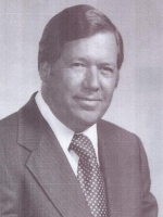
Raymond “Ray” Goad Sr.
| Birth | : | 18 Jul 1922 Mount Airy, Surry County, North Carolina, USA |
| Death | : | 23 Mar 2015 Mount Airy, Surry County, North Carolina, USA |
| Burial | : | Oakdale Cemetery, Mount Airy, Surry County, USA |
| Coordinate | : | 36.5177994, -80.6025009 |
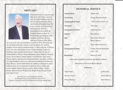
| Description | : | Though they have probably never heard of him, folks eating breakfast on the go today have him to thank, especially if they are eating anywhere at a fast food restaurant. Ray Goad, who died in Mount Airy, N.C. on March 23, 2015 at 92, was a fast food pioneer who can be credited with changing the way many American's eat breakfast. In the early 1970's there was not a single McDonalds, Wendy's or Hardee's that was open for breakfast anywhere. Ray Goad pioneered the concept by being the first to open for breakfast at his dozens of Ray's Kingburger restaurants... Read More |
frequently asked questions (FAQ):
-
Where is Raymond “Ray” Goad Sr.'s memorial?
Raymond “Ray” Goad Sr.'s memorial is located at: Oakdale Cemetery, Mount Airy, Surry County, USA.
-
When did Raymond “Ray” Goad Sr. death?
Raymond “Ray” Goad Sr. death on 23 Mar 2015 in Mount Airy, Surry County, North Carolina, USA
-
Where are the coordinates of the Raymond “Ray” Goad Sr.'s memorial?
Latitude: 36.5177994
Longitude: -80.6025009
Family Members:
Parent
Spouse
Siblings
Nearby Cemetories:
1. Oakdale Cemetery
Mount Airy, Surry County, USA
Coordinate: 36.5177994, -80.6025009
2. Grace Moravian God's Acre
Mount Airy, Surry County, USA
Coordinate: 36.5180016, -80.6042480
3. Campbell Cemetery
Mount Airy, Surry County, USA
Coordinate: 36.5135841, -80.6048172
4. First Baptist Church Columbarium
Mount Airy, Surry County, USA
Coordinate: 36.5071760, -80.6085860
5. Ararat Cemetery
Mount Airy, Surry County, USA
Coordinate: 36.5307999, -80.5922012
6. First Presbyterian Church Columbarium
Mount Airy, Surry County, USA
Coordinate: 36.4971990, -80.6057260
7. Catus Cemetery
Mount Airy, Surry County, USA
Coordinate: 36.5006111, -80.6212222
8. Old Methodist Cemetery
Mount Airy, Surry County, USA
Coordinate: 36.4948349, -80.6033630
9. Flat Rock Baptist Cemetery
Flat Rock, Surry County, USA
Coordinate: 36.5085983, -80.5749969
10. Salem United Methodist Church Cemetery
Salem, Surry County, USA
Coordinate: 36.5430565, -80.6026077
11. Mount Calvary Christian Methodist Episcopal Cemetery
Combstown, Surry County, USA
Coordinate: 36.5005470, -80.5794810
12. Mountain View Cemetery
Mount Airy, Surry County, USA
Coordinate: 36.5029660, -80.6304380
13. Sandy Level Cemetery
Toast, Surry County, USA
Coordinate: 36.5031013, -80.6307983
14. Creasy Family Cemetery
Mount Airy, Surry County, USA
Coordinate: 36.5131389, -80.6359722
15. Miracle Waters Worship Center Cemetery
Flat Rock, Surry County, USA
Coordinate: 36.5243250, -80.5691160
16. Old Hollow Primitive Baptist Church Cemetery
Toast, Surry County, USA
Coordinate: 36.4987221, -80.6281967
17. Critz Family Cemetery
Surry County, USA
Coordinate: 36.4960000, -80.6339170
18. Payne's Chapel Baptist Church Cemetery
Flat Rock, Surry County, USA
Coordinate: 36.5184200, -80.5609100
19. Norman Family Cemetery
Mount Airy, Surry County, USA
Coordinate: 36.4867516, -80.6183090
20. Midkiff Cemetery
Flat Rock, Surry County, USA
Coordinate: 36.5038986, -80.5642014
21. Oak Grove United Methodist Church Cemetery
Oak Grove (Mount Airy South), Surry County, USA
Coordinate: 36.4899770, -80.5757520
22. Midway Baptist Church Cemetery
Mount Airy, Surry County, USA
Coordinate: 36.5254170, -80.6467220
23. Forkner Cemetery
Mount Airy, Surry County, USA
Coordinate: 36.4978900, -80.5628510
24. Korner's Grove Primitive Baptist Church Cemetery
Flat Rock, Surry County, USA
Coordinate: 36.5359726, -80.5588913

