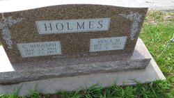
| Birth | : | 14 May 1874 Tekamah, Burt County, Nebraska, USA |
| Death | : | 25 Oct 1957 Fairmont, Fillmore County, Nebraska, USA |
| Burial | : | Fort Pitt Military Cemetery, Rochester, Medway Unitary Authority, England |
| Coordinate | : | 51.3769790, 0.5114570 |
| Description | : | Rebecca Ann Holmes Obit Rebecca Ann Holmes, daughter of Jacob and Carrie McCartney, was born May 14, 1874, Tekamah, Nebraska, and died at the Fairmont Nursing Home at Fairmont, Nebraska, October 25, 1957, at the age of 85 years, 6 months and 11 days. She was united in marriage to Alvin Clarence Holmes, July 30, 1890. To this union was born six children, all of whom are living; Robert Holmes of Ames, Iowa; Bernard Holmes' of Albion, Nebraska; Blossom Brandes of Hastings, Nebraska; Roland Holmes of Bennington, Nebraska; Beryl Anderson of Fullerton, Nebraska and Olive Anderson of Friend,... Read More |
frequently asked questions (FAQ):
-
Where is Rebecca Anne McCartney Holmes's memorial?
Rebecca Anne McCartney Holmes's memorial is located at: Fort Pitt Military Cemetery, Rochester, Medway Unitary Authority, England.
-
When did Rebecca Anne McCartney Holmes death?
Rebecca Anne McCartney Holmes death on 25 Oct 1957 in Fairmont, Fillmore County, Nebraska, USA
-
Where are the coordinates of the Rebecca Anne McCartney Holmes's memorial?
Latitude: 51.3769790
Longitude: 0.5114570
Family Members:
Parent
Spouse
Siblings
Children
Flowers:
Nearby Cemetories:
1. St. Nicholas's Cemetery
Rochester, Medway Unitary Authority, England
Coordinate: 51.3780081, 0.5021076
2. St. Margaret's Cemetery
Rochester, Medway Unitary Authority, England
Coordinate: 51.3777000, 0.5011600
3. Chatham Unitarian Church
Chatham, Medway Unitary Authority, England
Coordinate: 51.3826090, 0.5195850
4. Chatham Maidstone Road Cemetery
Chatham, Medway Unitary Authority, England
Coordinate: 51.3703300, 0.5227600
5. Rochester Baptist Church
Rochester, Medway Unitary Authority, England
Coordinate: 51.3871570, 0.5052370
6. St Margaret Churchyard
Rochester, Medway Unitary Authority, England
Coordinate: 51.3849380, 0.4993630
7. Chatham Burial Ground
Chatham, Medway Unitary Authority, England
Coordinate: 51.3849900, 0.5272600
8. Rochester Cathedral
Rochester, Medway Unitary Authority, England
Coordinate: 51.3889750, 0.5031160
9. Chatham Palmerston Road Cemetery
Chatham, Medway Unitary Authority, England
Coordinate: 51.3678600, 0.5267300
10. St Mary Churchyard
Chatham, Medway Unitary Authority, England
Coordinate: 51.3874550, 0.5244280
11. St Nicholas Churchyard
Rochester, Medway Unitary Authority, England
Coordinate: 51.3894170, 0.5035320
12. Rochester Castle Moat Burial Ground
Rochester, Medway Unitary Authority, England
Coordinate: 51.3894140, 0.5024580
13. Chatham Naval Memorial
Chatham, Medway Unitary Authority, England
Coordinate: 51.3836479, 0.5321670
14. St Matthew Churchyard
Borstal, Medway Unitary Authority, England
Coordinate: 51.3736150, 0.4868020
15. Brompton War Memorial
Chatham, Medway Unitary Authority, England
Coordinate: 51.3932140, 0.5293660
16. Strood Cemetery
Strood, Medway Unitary Authority, England
Coordinate: 51.3900220, 0.4838640
17. St Nicholas with St Mary Churchyard
Strood, Medway Unitary Authority, England
Coordinate: 51.3959790, 0.4931350
18. Christ Church Cemetery
Chatham, Medway Unitary Authority, England
Coordinate: 51.3716730, 0.5462690
19. St. Augustine's Church
Gillingham, Medway Unitary Authority, England
Coordinate: 51.3745050, 0.5474930
20. All Saints Churchyard
Frindsbury, Medway Unitary Authority, England
Coordinate: 51.4004440, 0.5058970
21. St. Barnabas Church
Gillingham, Medway Unitary Authority, England
Coordinate: 51.3801400, 0.5505370
22. St George Churchyard
Chatham, Medway Unitary Authority, England
Coordinate: 51.3974070, 0.5346770
23. St Mary Magdalene Churchyard
Gillingham, Medway Unitary Authority, England
Coordinate: 51.3903530, 0.5622230
24. St Philip and St James Churchyard
Upnor, Medway Unitary Authority, England
Coordinate: 51.4106250, 0.5250480


