
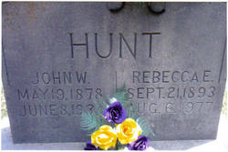
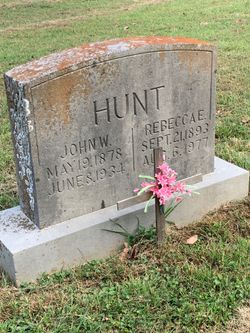
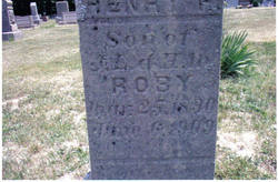
Rebecca Ellen Roby Hunt
| Birth | : | 21 Sep 1893 Orange County, Indiana, USA |
| Death | : | 6 Aug 1977 Orange County, Indiana, USA |
| Burial | : | Sanford Cemetery, Sanford, Conejos County, USA |
| Coordinate | : | 37.2374992, -105.9103012 |
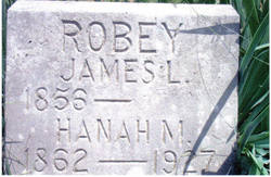
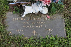
| Description | : | "Ellie" married brothers John William Hunt and Emery Clyde Hunt. She was the daughter of James Roby and Hannah Childers Roby. |
frequently asked questions (FAQ):
-
Where is Rebecca Ellen Roby Hunt's memorial?
Rebecca Ellen Roby Hunt's memorial is located at: Sanford Cemetery, Sanford, Conejos County, USA.
-
When did Rebecca Ellen Roby Hunt death?
Rebecca Ellen Roby Hunt death on 6 Aug 1977 in Orange County, Indiana, USA
-
Where are the coordinates of the Rebecca Ellen Roby Hunt's memorial?
Latitude: 37.2374992
Longitude: -105.9103012
Family Members:
Parent

Spouse

Siblings
Flowers:


Nearby Cemetories:
1. Sanford Cemetery
Sanford, Conejos County, USA
Coordinate: 37.2374992, -105.9103012
2. La Jara Cemetery
La Jara, Conejos County, USA
Coordinate: 37.2977982, -105.9610977
3. Old Manassa Cemetery
Manassa, Conejos County, USA
Coordinate: 37.1575012, -105.9366989
4. Sowards Cemetery
Manassa, Conejos County, USA
Coordinate: 37.1577988, -105.9381027
5. Nance Family Cemetery
Manassa, Conejos County, USA
Coordinate: 37.1569020, -105.9380870
6. Flower Family Graves
Manassa, Conejos County, USA
Coordinate: 37.1519000, -105.8915000
7. Los Cerritos Cemetery
Los Cerritos, Conejos County, USA
Coordinate: 37.1494000, -105.9127000
8. New Manassa Cemetery
Manassa, Conejos County, USA
Coordinate: 37.1486015, -105.9203033
9. Gate to Heaven Cemetery
Los Sauces, Conejos County, USA
Coordinate: 37.2375000, -105.7560000
10. Los Lasauses Pentecostal Cemetery
Los Sauces, Conejos County, USA
Coordinate: 37.2362520, -105.7557920
11. Los Sauces Church Yard Cemetery
Los Sauces, Conejos County, USA
Coordinate: 37.2658620, -105.7464570
12. La Isla Cemetery
Manassa, Conejos County, USA
Coordinate: 37.0864860, -105.9555750
13. Saint Joseph Cemetery
Conejos County, USA
Coordinate: 37.2841988, -106.0980988
14. Saint Joseph Church Old Cemetery
Capulin, Conejos County, USA
Coordinate: 37.2814000, -106.1118000
15. Old Capulin Cemetery
Capulin, Conejos County, USA
Coordinate: 37.2980995, -106.1097031
16. Lobatos Cemetery
Conejos County, USA
Coordinate: 37.0630989, -105.9116974
17. Conejos Cemetery
Antonito, Conejos County, USA
Coordinate: 37.0842018, -106.0175018
18. Warshaver Cemetery
Antonito, Conejos County, USA
Coordinate: 37.0828018, -106.0152969
19. Antonito Cemetery
Antonito, Conejos County, USA
Coordinate: 37.0819016, -106.0156021
20. Becker Cemetery
Alamosa County, USA
Coordinate: 37.3669014, -105.7478027
21. Alamosa Municipal Cemetery
Alamosa, Alamosa County, USA
Coordinate: 37.4495000, -105.8591000
22. Alamosa Spanish Cemetery
Alamosa, Alamosa County, USA
Coordinate: 37.4592000, -105.8929000
23. Mogote Presbyterian Cemetery
Mogote, Conejos County, USA
Coordinate: 37.0522003, -106.0868988
24. Las Mesitas Cemetery
Las Mesitas, Conejos County, USA
Coordinate: 37.0651770, -106.1091540