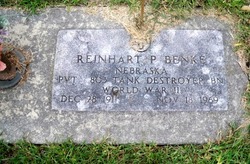
Reinhart P. Benke
| Birth | : | 28 Dec 1911 Elkhorn, Douglas County, Nebraska, USA |
| Death | : | 18 Nov 1969 Butler County, Nebraska, USA |
| Burial | : | St Ambrose Churchyard, Grindleton, Ribble Valley Borough, England |
| Coordinate | : | 53.9061710, -2.3633270 |
| Description | : | http://www.rootsweb.ancestry.com/~neplatte/vitals/vitals1969.html The Daily Telegram, November 19, 1969 BENKE; TOPIL--Funeral rites set Friday for wreck victims Funeral arrangements have been announced for Reinhart B. Benke of Columbus and Joseph I. Topil of Rising City, victims of a Tuesday morning traffic accident a mile north of St. Joseph Catholic Church. Services for Mr. Benke, 57, of 571 22nd Avenue, will be held at 2 p.m. Friday at McKown Funeral Home, with the Rev. Russell Mertz officiating, and burial will be in Columbus Cemetery. The body is to lie in state at the funeral home after 1... Read More |
frequently asked questions (FAQ):
-
Where is Reinhart P. Benke's memorial?
Reinhart P. Benke's memorial is located at: St Ambrose Churchyard, Grindleton, Ribble Valley Borough, England.
-
When did Reinhart P. Benke death?
Reinhart P. Benke death on 18 Nov 1969 in Butler County, Nebraska, USA
-
Where are the coordinates of the Reinhart P. Benke's memorial?
Latitude: 53.9061710
Longitude: -2.3633270
Family Members:
Parent
Spouse
Siblings
Flowers:
Nearby Cemetories:
1. St Ambrose Churchyard
Grindleton, Ribble Valley Borough, England
Coordinate: 53.9061710, -2.3633270
2. Grindleton Methodist Cemetery
Grindleton, Ribble Valley Borough, England
Coordinate: 53.9080420, -2.3684420
3. Christ Churchyard
Chatburn, Ribble Valley Borough, England
Coordinate: 53.8940690, -2.3515030
4. Sawley Abbey
Sawley, Ribble Valley Borough, England
Coordinate: 53.9131920, -2.3417080
5. St. Leonard's Churchyard
Downham, Ribble Valley Borough, England
Coordinate: 53.8944340, -2.3294250
6. St Helen Churchyard
Waddington, Ribble Valley Borough, England
Coordinate: 53.8898700, -2.4143900
7. St. Joseph's Roman Catholic Cemetery
Clitheroe, Ribble Valley Borough, England
Coordinate: 53.8770700, -2.3960000
8. Clitheroe Cemetery
Clitheroe, Ribble Valley Borough, England
Coordinate: 53.8779250, -2.3984550
9. St Mary Magdalene Churchyard
Clitheroe, Ribble Valley Borough, England
Coordinate: 53.8740980, -2.3903420
10. Holden Chapel
Bolton-by-Bowland, Ribble Valley Borough, England
Coordinate: 53.9420850, -2.3500060
11. St Peter and St Paul Churchyard
Bolton-by-Bowland, Ribble Valley Borough, England
Coordinate: 53.9399800, -2.3270300
12. Trinity Methodist Churchyard
Clitheroe, Ribble Valley Borough, England
Coordinate: 53.8709060, -2.3954550
13. St James Churchyard
Clitheroe, Ribble Valley Borough, England
Coordinate: 53.8659600, -2.3922700
14. Twiston Quaker Burial Ground
Clitheroe, Ribble Valley Borough, England
Coordinate: 53.8854210, -2.2838840
15. Salem Congregational Chapel Martin Top
Rimington, Ribble Valley Borough, England
Coordinate: 53.9072484, -2.2740463
16. St. Mary the Virgin Churchyard
Gisburn, Ribble Valley Borough, England
Coordinate: 53.9356080, -2.2605210
17. All Hallows Churchyard
Great Mitton, Ribble Valley Borough, England
Coordinate: 53.8461500, -2.4339000
18. Saint Nicholas Parish Churchyard
Sabden, Ribble Valley Borough, England
Coordinate: 53.8346503, -2.3332764
19. St Andrew Churchyard
Slaidburn, Ribble Valley Borough, England
Coordinate: 53.9641600, -2.4437090
20. St. Mary's Churchyard
Newchurch in Pendle, Pendle Borough, England
Coordinate: 53.8504181, -2.2706807
21. Queen Mary's Military Hospital Cemetery
Whalley, Ribble Valley Borough, England
Coordinate: 53.8337490, -2.4127930
22. Calderstones Hospital Cemetery
Whalley, Ribble Valley Borough, England
Coordinate: 53.8338710, -2.4147160
23. Whalley, Wiswell and Barrow Cemetery
Whalley, Ribble Valley Borough, England
Coordinate: 53.8308490, -2.4057280
24. Saint Mary and All Saints Churchyard
Whalley, Ribble Valley Borough, England
Coordinate: 53.8211890, -2.4078080


