
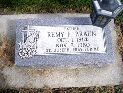
Remy F. Braun
| Birth | : | 1 Oct 1914 Humphrey, Platte County, Nebraska, USA |
| Death | : | 3 Nov 1980 Columbus, Platte County, Nebraska, USA |
| Burial | : | All Saints Churchyard, Poringland, South Norfolk District, England |
| Coordinate | : | 52.5657160, 1.3496310 |
| Description | : | http://www.rootsweb.ancestry.com/~neplatte/vitals/vitals1980.html The Columbus Telegram, November 3, 1980 BRAUN--Remy F. Braun Remy F. Braun, 66, of 556 10th St., died Monday morning in Columbus Community Hospital after a lingering illness. Services will be at 10:30 a.m. Wednesday in St. Anthony Church with the Rev. Laurin Buzynski officiating. Burial will be in St. Bonaventure Cemetery. Visitation will be after 4 p.m. with a rosary at 7:30 p.m. Tuesday in McKown Funeral Home. Mr. Braun was born in St. Mary's Hospital in Humphrey Oct. 1, 1914, son of John and Margaret Bach... Read More |
frequently asked questions (FAQ):
-
Where is Remy F. Braun's memorial?
Remy F. Braun's memorial is located at: All Saints Churchyard, Poringland, South Norfolk District, England.
-
When did Remy F. Braun death?
Remy F. Braun death on 3 Nov 1980 in Columbus, Platte County, Nebraska, USA
-
Where are the coordinates of the Remy F. Braun's memorial?
Latitude: 52.5657160
Longitude: 1.3496310
Family Members:
Parent
Spouse
Siblings
Children
Flowers:


Nearby Cemetories:
1. All Saints Churchyard
Poringland, South Norfolk District, England
Coordinate: 52.5657160, 1.3496310
2. St Andrew Churchyard
Framingham Earl, South Norfolk District, England
Coordinate: 52.5748560, 1.3596480
3. St Mary Churchyard
Howe, South Norfolk District, England
Coordinate: 52.5497970, 1.3541770
4. St Andrew Churchyard
Framingham Pigot, South Norfolk District, England
Coordinate: 52.5826070, 1.3606380
5. St Peters Churchyard
Brooke, South Norfolk District, England
Coordinate: 52.5452560, 1.3814930
6. St Mary Churchyard
Arminghall, South Norfolk District, England
Coordinate: 52.5900300, 1.3234620
7. St Wandregesilus Churchyard
Bixley, South Norfolk District, England
Coordinate: 52.5955900, 1.3330900
8. All Saints Church
Shotesham, South Norfolk District, England
Coordinate: 52.5428610, 1.3120560
9. Saint Andrews
Kirby Bedon, South Norfolk District, England
Coordinate: 52.5989160, 1.3635240
10. St Peter Churchyard
Bramerton, South Norfolk District, England
Coordinate: 52.5914090, 1.3885040
11. St Margaret's Churchyard
Kirstead, South Norfolk District, England
Coordinate: 52.5358860, 1.3840860
12. Saint Edmund Churchyard
Caistor St Edmund, South Norfolk District, England
Coordinate: 52.5826350, 1.2936850
13. St Remigius Churchyard
Dunston, South Norfolk District, England
Coordinate: 52.5722420, 1.2872510
14. St. Peter and St. Paul Churchyard
Bergh Apton, South Norfolk District, England
Coordinate: 52.5480290, 1.4060870
15. St Mary Churchyard
Shotesham, South Norfolk District, England
Coordinate: 52.5411110, 1.2985880
16. St. John the Baptist Churchyard
Hellington, South Norfolk District, England
Coordinate: 52.5761440, 1.4132050
17. St. Mary's Churchyard
Rockland St Mary, South Norfolk District, England
Coordinate: 52.5843940, 1.4112390
18. St. John the Baptist Churchyard
Lakenham, City of Norwich, England
Coordinate: 52.6068660, 1.2971750
19. St Mary's Parish Churchyard
Ashby St Mary, South Norfolk District, England
Coordinate: 52.5679100, 1.4354760
20. St Andrews
Claxton, South Norfolk District, England
Coordinate: 52.5769660, 1.4340060
21. St. Mary's Churchyard
Saxlingham Nethergate, South Norfolk District, England
Coordinate: 52.5268910, 1.2880390
22. St Margaret and St Remigius Churchyard
Seething, South Norfolk District, England
Coordinate: 52.5303390, 1.4185000
23. All Saints Churchyard
Keswick, South Norfolk District, England
Coordinate: 52.5951470, 1.2675790
24. St Peter's Churchyard
Mundham, South Norfolk District, England
Coordinate: 52.5303890, 1.4260120