Reuben Clarence “Slim” Meckle
| Birth | : | 11 Sep 1927 Denhoff, Sheridan County, North Dakota, USA |
| Death | : | 11 Oct 2007 Miles City, Custer County, Montana, USA |
| Burial | : | Saint Joseph's Catholic Cemetery, Millbrook, Dutchess County, USA |
| Coordinate | : | 41.7861800, -73.6974500 |
| Plot | : | Block A Row 6 Plot 19 |
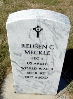
| Inscription | : | TEC4 US ARMY WORLD WAR II |
| Description | : | Reuben "Slim" Meckle, 80, of Miles City, passed away at home in Miles City on Thursday, October 11, 2007, surrounded by his family. Slim was born September 11, 1927 in Denhoff, North Dakota to Emanuel Meckle and Lydia (Richter) Meckle. He was raised and attended school in the Denhoff and McClusky areas. Slim served in the US Army for two years during WWII as MP. After completing his time of service, Slim worked on various ranches throughout Eastern Montana. Slim married Loretta Stein on July 2, 1950 at the family farm in McClusky... Read More |
frequently asked questions (FAQ):
-
Where is Reuben Clarence “Slim” Meckle's memorial?
Reuben Clarence “Slim” Meckle's memorial is located at: Saint Joseph's Catholic Cemetery, Millbrook, Dutchess County, USA.
-
When did Reuben Clarence “Slim” Meckle death?
Reuben Clarence “Slim” Meckle death on 11 Oct 2007 in Miles City, Custer County, Montana, USA
-
Where are the coordinates of the Reuben Clarence “Slim” Meckle's memorial?
Latitude: 41.7861800
Longitude: -73.6974500
Family Members:
Parent
Spouse
Siblings
Children
Flowers:
Nearby Cemetories:
1. Saint Joseph's Catholic Cemetery
Millbrook, Dutchess County, USA
Coordinate: 41.7861800, -73.6974500
2. Grace Episcopal Church Memorial Garden
Millbrook, Dutchess County, USA
Coordinate: 41.7854190, -73.6891670
3. Nine Partners Cemetery
Millbrook, Dutchess County, USA
Coordinate: 41.7764015, -73.6889038
4. Haight Cemetery
Dutchess County, USA
Coordinate: 41.7602997, -73.6568985
5. Kerk Hof Cemetery
Dutchess County, USA
Coordinate: 41.7644539, -73.7471542
6. Pittsbury Presbyterian Churchyard
Washington Hollow, Dutchess County, USA
Coordinate: 41.7822100, -73.7576400
7. Verbank Cemetery
Verbank, Dutchess County, USA
Coordinate: 41.7271700, -73.7148900
8. Creek Meeting House Friends Cemetery
Clinton Corners, Dutchess County, USA
Coordinate: 41.8314290, -73.7621780
9. Friends Cemetery
Clinton Corners, Dutchess County, USA
Coordinate: 41.8315290, -73.7621690
10. Lyon Family Burial Ground
Clinton Corners, Dutchess County, USA
Coordinate: 41.8336945, -73.7622070
11. Northrup Burial Ground
Lithgow, Dutchess County, USA
Coordinate: 41.8256330, -73.6189660
12. Upton Lake Cemetery
Dutchess County, USA
Coordinate: 41.8400002, -73.7621994
13. Saint Peter's Episcopal Cemetery
Lithgow, Dutchess County, USA
Coordinate: 41.8295400, -73.6195600
14. Salt Point Cemetery
Salt Point, Dutchess County, USA
Coordinate: 41.8044300, -73.7948700
15. Chestnut Ridge Friends Burial Ground
Dover Plains, Dutchess County, USA
Coordinate: 41.7319000, -73.6275900
16. Stanford Cemetery
Stanfordville, Dutchess County, USA
Coordinate: 41.8636017, -73.7149963
17. Friends Burial Ground
Stanfordville, Dutchess County, USA
Coordinate: 41.8677230, -73.7136910
18. Saint Mary's Catholic Cemetery
Stanfordville, Dutchess County, USA
Coordinate: 41.8722000, -73.6958008
19. Oswego Friends Burial Ground
Moores Mill, Dutchess County, USA
Coordinate: 41.7020840, -73.7289720
20. Netherwood Baptist Church Cemetery
Salt Point, Dutchess County, USA
Coordinate: 41.7986832, -73.8183975
21. Methodist Episcopal Church Cemetery
Pleasant Valley, Dutchess County, USA
Coordinate: 41.7505656, -73.8100419
22. Saint Pauls Church Cemetery
Pleasant Valley, Dutchess County, USA
Coordinate: 41.7468900, -73.8155800
23. Bangall Baptist Church Cemetery #2
Bangall, Dutchess County, USA
Coordinate: 41.8832470, -73.6952900
24. Separate Church Grounds
Millbrook, Dutchess County, USA
Coordinate: 41.8565490, -73.6070850


