
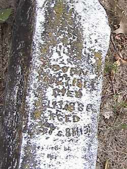
Rev John D. "Baptist" Wood
| Birth | : | 27 Feb 1813 Logan County, Kentucky, USA |
| Death | : | 11 Oct 1888 California, Moniteau County, Missouri, USA |
| Burial | : | St. Luke Churchyard, Formby, Metropolitan Borough of Sefton, England |
| Coordinate | : | 53.5520000, -3.0869800 |
| Description | : | Rev. John D. Wood was a Baptist preacher. Father: John Wood b. Aug 10, 1768 Frederick County, Maryland d. Sep 15 1853 Russellville, Logan, Kentucky Soon after the Revolutionary War he settled in Kentucky. John had 15 brothers. 3 were Captains in the War for Independence. Marriage Aug 3, 1797 Mother: Sarah Sally Hughes b. Sep 29 1777 Virginia d. Mar 29 1843 Russellville, Logan, Kentucky 12 Children, 10 boys, 2 girls John D. Wood 1st married Dec. 17, 1831 Logan County, Kentucky to Elizabeth J. Sanders b. Aug. 23, 1813 d. unknown 3 Children: James Green... Read More |
frequently asked questions (FAQ):
-
Where is Rev John D. "Baptist" Wood's memorial?
Rev John D. "Baptist" Wood's memorial is located at: St. Luke Churchyard, Formby, Metropolitan Borough of Sefton, England.
-
When did Rev John D. "Baptist" Wood death?
Rev John D. "Baptist" Wood death on 11 Oct 1888 in California, Moniteau County, Missouri, USA
-
Where are the coordinates of the Rev John D. "Baptist" Wood's memorial?
Latitude: 53.5520000
Longitude: -3.0869800
Family Members:
Parent
Spouse

Siblings
Children
Flowers:


Nearby Cemetories:
1. St. Luke Churchyard
Formby, Metropolitan Borough of Sefton, England
Coordinate: 53.5520000, -3.0869800
2. Our Lady Of Compassion RC Churchyard
Formby, Metropolitan Borough of Sefton, England
Coordinate: 53.5574060, -3.0575020
3. St. Peter's Churchyard
Formby, Metropolitan Borough of Sefton, England
Coordinate: 53.5663834, -3.0594721
4. St. Michael and All Angels Churchyard
Great Altcar, Metropolitan Borough of Sefton, England
Coordinate: 53.5507770, -3.0279540
5. Ince Blundell Cemetery
Ince Blundell, Metropolitan Borough of Sefton, England
Coordinate: 53.5213570, -3.0208750
6. St. Mary Roman Catholic Churchyard
Little Crosby, Metropolitan Borough of Sefton, England
Coordinate: 53.5076380, -3.0274720
7. Harkirk Burial Ground
Little Crosby, Metropolitan Borough of Sefton, England
Coordinate: 53.5016890, -3.0191220
8. Sacred Heart RC Cemetery
Birkdale, Metropolitan Borough of Sefton, England
Coordinate: 53.6066100, -3.0270100
9. Liverpool Road Cemetery
Birkdale, Metropolitan Borough of Sefton, England
Coordinate: 53.6083620, -3.0257140
10. St Luke Churchyard
Great Crosby, Metropolitan Borough of Sefton, England
Coordinate: 53.4909310, -3.0240300
11. St Thomas Churchyard
Lydiate, Metropolitan Borough of Sefton, England
Coordinate: 53.5443480, -2.9621640
12. Thornton Garden of Rest and Crematorium
Thornton, Metropolitan Borough of Sefton, England
Coordinate: 53.5001850, -2.9951960
13. St Peter and St Paul Churchyard
Crosby, Metropolitan Borough of Sefton, England
Coordinate: 53.4858300, -3.0234920
14. St Catherine Churchyard
Lydiate, Metropolitan Borough of Sefton, England
Coordinate: 53.5368000, -2.9612660
15. Our Lady's Roman Catholic Churchyard
Lydiate, Metropolitan Borough of Sefton, England
Coordinate: 53.5396850, -2.9599940
16. St Faiths Churchyard
Waterloo, Metropolitan Borough of Sefton, England
Coordinate: 53.4810510, -3.0230370
17. Sefton Parish Churchyard
Sefton, Metropolitan Borough of Sefton, England
Coordinate: 53.5044060, -2.9712190
18. St. Cuthbert's Churchyard
Halsall, West Lancashire District, England
Coordinate: 53.5852140, -2.9529650
19. Ford Cemetery
Ford, Metropolitan Borough of Sefton, England
Coordinate: 53.4824040, -2.9925980
20. St. Andrew Churchyard
Maghull, Metropolitan Borough of Sefton, England
Coordinate: 53.5104770, -2.9428820
21. Ardwick Cemetery
Ardwick, Metropolitan Borough of Manchester, England
Coordinate: 53.6302778, -2.9900000
22. Christ Church Churchyard
Southport, Metropolitan Borough of Sefton, England
Coordinate: 53.6327778, -2.9953770
23. Duke Street Cemetery
Southport, Metropolitan Borough of Sefton, England
Coordinate: 53.6343536, -2.9993131
24. Saint Michael's Churchyard
Aughton, West Lancashire District, England
Coordinate: 53.5419170, -2.9197240