
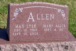
Rev Max Lyle Allen
| Birth | : | 12 Dec 1925 Washta, Cherokee County, Iowa, USA |
| Death | : | 10 Sep 2008 Zumbrota, Goodhue County, Minnesota, USA |
| Burial | : | Papatoetoe Cemetery, Papatoetoe, Auckland Council, New Zealand |
| Coordinate | : | -36.9893110, 174.8373530 |
| Description | : | Max Lyle Allen, 83, died September 10, 2008, at his home in Zumbrota, Minnesota. Max was born December 12, 1925, in Washta, the son of Ralph J. and Iva Mae (Nafe) Allen. He spent his early years in Washta and Quimby, and graduated from Grand Meadow High School, Cherokee Co., Iowa, in 1943. Max attended York College and graduated in 1947. On June 18, 1948, he married Mary Alice Riggs in Ames. He graduated from Bonebrake Seminary in Dayton, Ohio in 1950. Max pastored at the Evangelical United Brethren in Cranston, Iowa, for 10 years. In 1960 they moved... Read More |
frequently asked questions (FAQ):
-
Where is Rev Max Lyle Allen's memorial?
Rev Max Lyle Allen's memorial is located at: Papatoetoe Cemetery, Papatoetoe, Auckland Council, New Zealand.
-
When did Rev Max Lyle Allen death?
Rev Max Lyle Allen death on 10 Sep 2008 in Zumbrota, Goodhue County, Minnesota, USA
-
Where are the coordinates of the Rev Max Lyle Allen's memorial?
Latitude: -36.9893110
Longitude: 174.8373530
Family Members:
Parent

Spouse

Siblings


Flowers:


Nearby Cemetories:
1. Papatoetoe Cemetery
Papatoetoe, Auckland Council, New Zealand
Coordinate: -36.9893110, 174.8373530
2. Manukau Memorial Gardens
Manukau, Auckland Council, New Zealand
Coordinate: -36.9944380, 174.8397300
3. St. John's Presbyterian Church Cemetery
Papatoetoe, Auckland Council, New Zealand
Coordinate: -36.9674185, 174.8598178
4. Woodside Methodist Cemetery
Manukau, Auckland Council, New Zealand
Coordinate: -36.9929680, 174.8837860
5. Mangere Presbyterian Cemetery
Mangere, Auckland Council, New Zealand
Coordinate: -36.9750197, 174.7924783
6. Nixon Memorial
Ōtāhūhū, Auckland Council, New Zealand
Coordinate: -36.9499366, 174.8449909
7. St. David's Anglican Churchyard
Wiri, Auckland Council, New Zealand
Coordinate: -37.0025400, 174.8886150
8. St. Joseph and St. Joachim Catholic Cemetery
Ōtāhūhū, Auckland Council, New Zealand
Coordinate: -36.9436100, 174.8490100
9. Mangere Lawn Cemetery
Mangere, Auckland Council, New Zealand
Coordinate: -36.9626150, 174.7857000
10. Otahuhu Public Cemetery
Ōtāhūhū, Auckland Council, New Zealand
Coordinate: -36.9377500, 174.8432390
11. Holy Trinity Memorial Park
Ōtāhūhū, Auckland Council, New Zealand
Coordinate: -36.9374510, 174.8448580
12. Laurie-Gibbons Memorial Park
Weymouth, Auckland Council, New Zealand
Coordinate: -37.0440600, 174.8586790
13. St. John's Church Cemetery
East Tamaki, Auckland Council, New Zealand
Coordinate: -36.9522250, 174.8964540
14. St. Paul's Anglican Cemetery
East Tamaki, Auckland Council, New Zealand
Coordinate: -36.9615200, 174.9082000
15. Mangere Piriti Urupā St. James Churchyard
Mangere, Auckland Council, New Zealand
Coordinate: -36.9418970, 174.7835260
16. Flat Bush Cemetery
East Tamaki, Auckland Council, New Zealand
Coordinate: -36.9563500, 174.9097100
17. Waikaraka Cemetery
Ōnehunga, Auckland Council, New Zealand
Coordinate: -36.9297140, 174.7967170
18. Onehunga Catholic Cemetery
Ōnehunga, Auckland Council, New Zealand
Coordinate: -36.9224360, 174.7884560
19. Our Lady of the Assumption Catholic Church
Ōnehunga, Auckland Council, New Zealand
Coordinate: -36.9223690, 174.7884530
20. St. Peter's Anglican Cemetery
Ōnehunga, Auckland Council, New Zealand
Coordinate: -36.9227113, 174.7847550
21. St Matthias Churchyard
Panmure, Auckland Council, New Zealand
Coordinate: -36.9053300, 174.8577200
22. St. Patrick's Roman Catholic Church Cemetery
Panmure, Auckland Council, New Zealand
Coordinate: -36.9029680, 174.8564960
23. Alfriston Cemetery
Auckland Council, New Zealand
Coordinate: -37.0133660, 174.9479400
24. Hillsborough Cemetery
Hillsborough, Auckland Council, New Zealand
Coordinate: -36.9246600, 174.7524030