
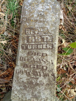
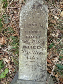
Rev Robert Turner
| Birth | : | Feb 1811 |
| Death | : | Jan 1881 |
| Burial | : | West Branch Cemetery, Pawnee County, USA |
| Coordinate | : | 40.0787940, -96.2797160 |
| Description | : | The earliest settlers of Pawnee County located in the vicinity of Cincinnati, a little village situated in its extreme southeastern portion, about fourteen miles from Pawnee City. In the spring of 1854, Christian Bobst, Robert Turner, Jacob Adams and Robert Archer started from Ohio with a view of settling in Missouri, on the Hannibal & St. Joe Railroad. They found, however, that the lands were not in the market, and pushed on into Nebraska. Name Robert Turner Age 39 Birth Year abt 1811 Birthplace Ohio Home in 1850 Richmond, Ashtabula, Ohio, USA Gender Male Family Number 114 |
frequently asked questions (FAQ):
-
Where is Rev Robert Turner's memorial?
Rev Robert Turner's memorial is located at: West Branch Cemetery, Pawnee County, USA.
-
When did Rev Robert Turner death?
Rev Robert Turner death on Jan 1881 in
-
Where are the coordinates of the Rev Robert Turner's memorial?
Latitude: 40.0787940
Longitude: -96.2797160
Family Members:
Parent
Spouse
Siblings
Children

Flowers:


Nearby Cemetories:
1. West Branch Cemetery
Pawnee County, USA
Coordinate: 40.0787940, -96.2797160
2. Johnson Creek Cemetery
Pawnee City, Pawnee County, USA
Coordinate: 40.0270000, -96.2465000
3. Burchard Cemetery
Burchard, Pawnee County, USA
Coordinate: 40.1383018, -96.3538971
4. Summerfield Cemetery
Summerfield, Marshall County, USA
Coordinate: 40.0005989, -96.3422012
5. Holy Family Cemetery
Summerfield, Marshall County, USA
Coordinate: 39.9994011, -96.3414001
6. Madden Cemetery
Axtell, Marshall County, USA
Coordinate: 39.9866800, -96.2490300
7. Sacred Heart Cemetery
Burchard, Pawnee County, USA
Coordinate: 40.1460991, -96.3683014
8. Pawnee City Cemetery
Pawnee City, Pawnee County, USA
Coordinate: 40.1109009, -96.1608810
9. Pleasant Valley Cemetery
Pawnee County, USA
Coordinate: 40.0299988, -96.1554794
10. Evergreen Cemetery
Pawnee County, USA
Coordinate: 40.0485992, -96.1417007
11. Tanner Cemetery
Pawnee County, USA
Coordinate: 40.0238991, -96.4143982
12. Pleasant Ridge Cemetery
Du Bois, Pawnee County, USA
Coordinate: 40.0156000, -96.1494000
13. Saint Bridget Cemetery
Axtell, Marshall County, USA
Coordinate: 39.9572000, -96.2578000
14. Mission Creek Cemetery
Pawnee County, USA
Coordinate: 40.0149994, -96.4263992
15. Saint Anthonys Cemetery
Steinauer, Pawnee County, USA
Coordinate: 40.2075005, -96.2189026
16. Salems Cemetery
Steinauer, Pawnee County, USA
Coordinate: 40.2166000, -96.2555000
17. McCaffrey Cemetery
Nemaha County, USA
Coordinate: 39.9827100, -96.1474500
18. Mount Pleasant Cemetery
Burchard, Pawnee County, USA
Coordinate: 40.1822014, -96.4049988
19. Prairie Star Pioneer Cemetery
Du Bois, Pawnee County, USA
Coordinate: 40.0293000, -96.1041000
20. Brewer Cemetery
Baileyville, Nemaha County, USA
Coordinate: 39.9556900, -96.1736500
21. Shockleys Fairland Cemetery
Marshall County, USA
Coordinate: 39.9284500, -96.2866500
22. Saint Peters Evangelican Cemetery
Du Bois, Pawnee County, USA
Coordinate: 40.0010000, -96.1095000
23. Beranek Cemetery
Table Rock, Pawnee County, USA
Coordinate: 40.2042007, -96.1607971
24. Richland Center Cemetery
Marshall County, USA
Coordinate: 39.9584000, -96.4073700