
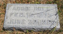
Rhoda Mary Kellogg Dorst
| Birth | : | 14 Dec 1849 Nodaway, Andrew County, Missouri, USA |
| Death | : | 16 Jul 1877 Andrew County, Missouri, USA |
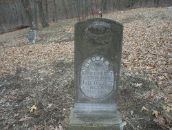
| Burial | : | Fairview Christian Cemetery, Rosendale, Andrew County, USA |
| Coordinate | : | 40.0102090, -94.8198890 |
| Description | : | Rhoda Kellogg was the daughter of John and Rachel (Small) Kellogg. She married Henry Dorst on October 12, 1867 in Andrew County, Missouri. Henry was the son of Henry and Margaret (Wells) Dorst. To this union five children were born Sarah, Melissa, Addie, Florence and John. Census 1850 Andrew County, Missouri Census 1860 Andrew County, Missouri Census 1870 Nodaway County, Missouri |
frequently asked questions (FAQ):
-
Where is Rhoda Mary Kellogg Dorst's memorial?
Rhoda Mary Kellogg Dorst's memorial is located at: Fairview Christian Cemetery, Rosendale, Andrew County, USA.
-
When did Rhoda Mary Kellogg Dorst death?
Rhoda Mary Kellogg Dorst death on 16 Jul 1877 in Andrew County, Missouri, USA
-
Where are the coordinates of the Rhoda Mary Kellogg Dorst's memorial?
Latitude: 40.0102090
Longitude: -94.8198890
Family Members:
Parent
Spouse
Siblings

Children
Flowers:


Nearby Cemetories:
1. Fairview Christian Cemetery
Rosendale, Andrew County, USA
Coordinate: 40.0102090, -94.8198890
2. Coffman Cemetery
Wyeth, Andrew County, USA
Coordinate: 39.9961014, -94.8099976
3. Kellogg Cemetery
Andrew County, USA
Coordinate: 39.9961014, -94.8494034
4. McGlothlin Cemetery
Andrew County, USA
Coordinate: 40.0097700, -94.7740400
5. Bennett Lane Cemetery
Savannah, Andrew County, USA
Coordinate: 39.9961014, -94.8786011
6. Lower Neely Grove Cemetery
Andrew County, USA
Coordinate: 40.0627594, -94.8138733
7. Bedford Chapel Cemetery
Andrew County, USA
Coordinate: 39.9886017, -94.7481003
8. McBrien Cemetery
Rosendale, Andrew County, USA
Coordinate: 40.0698900, -94.8589600
9. Clemmens Cemetery
Whitesville, Andrew County, USA
Coordinate: 40.0401430, -94.7413400
10. Daily Cemetery
Savannah, Andrew County, USA
Coordinate: 39.9652960, -94.7497470
11. Earls Cemetery
Savannah, Andrew County, USA
Coordinate: 39.9375000, -94.8028030
12. Gillispie Cemetery
Andrew County, USA
Coordinate: 39.9775009, -94.9067001
13. Savannah Cemetery
Savannah, Andrew County, USA
Coordinate: 39.9361000, -94.8292007
14. La Verna Heights Cemetery
Savannah, Andrew County, USA
Coordinate: 39.9328800, -94.8259000
15. Old Union Cemetery
Andrew County, USA
Coordinate: 39.9378014, -94.8803024
16. Mount Carmel Cemetery
Savannah, Andrew County, USA
Coordinate: 39.9378891, -94.8807831
17. Clizer Cemetery
Fillmore, Andrew County, USA
Coordinate: 39.9791985, -94.9336014
18. Andrew County Poor Farm Cemetery
Savannah, Andrew County, USA
Coordinate: 39.9309100, -94.7566530
19. Hackberry Cemetery
Andrew County, USA
Coordinate: 39.9446983, -94.9064026
20. Whitesville Cemetery
Whitesville, Andrew County, USA
Coordinate: 40.0626183, -94.7162094
21. Foultz Cemetery
Fillmore, Andrew County, USA
Coordinate: 40.0104110, -94.9457630
22. Gravel Wall Cemetery
Andrew County, USA
Coordinate: 40.0672210, -94.9260280
23. Upper Neely Grove Cemetery
Bolckow, Andrew County, USA
Coordinate: 40.1083488, -94.7961807
24. Walnut Grove Methodist Cemetery
Andrew County, USA
Coordinate: 40.0967598, -94.7518311