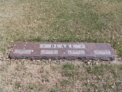
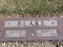
Richard Elon Blake
| Birth | : | 12 Sep 1853 Quebec, Canada |
| Death | : | 21 Apr 1923 Mellette, Spink County, South Dakota, USA |
| Burial | : | Mount Olivet Cemetery, Watertown, Litchfield County, USA |
| Coordinate | : | 41.6185989, -73.1492004 |
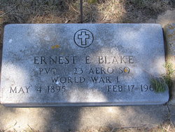
| Description | : | Richard Elon Blake died at the age of 10d 7m 70yrs from chronic nephritis. 13 Jan 1900 Mellette, Spink, SD census Blake Richard, head, Sep 1853,m15yrs, Canada Eng (born Shipton, Quebec, Canada); Alice M,(Alice May Newell) wife, May 1857, m15yrs, 4, 3, Wis; Pearl J, daughter, Jun 1887, SD; Lucy M, daughter, (Lucy May born 13 Apr 1889, Spink Co, SD); Ernest E, son, (Ernest Elon born 4 May 1895, Spink Co, SD). 1920 Mellette, Spink, SD census Blake Richard E, head, 67, Can, 1875, Na, 1880; Alice, wife, 62, Wis; Ernest, son, 24, SD. Ernest married... Read More |
frequently asked questions (FAQ):
-
Where is Richard Elon Blake's memorial?
Richard Elon Blake's memorial is located at: Mount Olivet Cemetery, Watertown, Litchfield County, USA.
-
When did Richard Elon Blake death?
Richard Elon Blake death on 21 Apr 1923 in Mellette, Spink County, South Dakota, USA
-
Where are the coordinates of the Richard Elon Blake's memorial?
Latitude: 41.6185989
Longitude: -73.1492004
Family Members:
Spouse
Children
Flowers:
Nearby Cemetories:
1. Mount Olivet Cemetery
Watertown, Litchfield County, USA
Coordinate: 41.6185989, -73.1492004
2. Evergreen Cemetery
Watertown, Litchfield County, USA
Coordinate: 41.6082993, -73.1235962
3. Mount Saint James Cemetery
Watertown, Litchfield County, USA
Coordinate: 41.6100006, -73.1093979
4. Old Watertown Cemetery
Watertown, Litchfield County, USA
Coordinate: 41.5993996, -73.1138992
5. Abbey of Regina Laudis Cemetery
Bethlehem, Litchfield County, USA
Coordinate: 41.6116400, -73.2100800
6. Evergreen Cemetery
Bethlehem, Litchfield County, USA
Coordinate: 41.6306000, -73.2099991
7. Old Bethlehem Cemetery
Bethlehem, Litchfield County, USA
Coordinate: 41.6486015, -73.2089005
8. All Saints Episcopal Church Memorial Garden
Oakville, Litchfield County, USA
Coordinate: 41.5885620, -73.0856160
9. Hillside Cemetery
Thomaston, Litchfield County, USA
Coordinate: 41.6685982, -73.0819016
10. Fort Hill Cemetery
Waterbury, New Haven County, USA
Coordinate: 41.5943413, -73.0548553
11. Farband Cemetery
Morris, Litchfield County, USA
Coordinate: 41.6890182, -73.1839447
12. Morris Burying Ground
Morris, Litchfield County, USA
Coordinate: 41.6883300, -73.1865400
13. Carmel Hill Cemetery
Bethlehem, Litchfield County, USA
Coordinate: 41.6385994, -73.2481003
14. Thomaston Veterans Monument
Thomaston, Litchfield County, USA
Coordinate: 41.6739640, -73.0727780
15. New North Cemetery
Woodbury, Litchfield County, USA
Coordinate: 41.5519280, -73.2106860
16. Old North Cemetery
Woodbury, Litchfield County, USA
Coordinate: 41.5506070, -73.2096290
17. Orton Family Plot
Woodbury, Litchfield County, USA
Coordinate: 41.5488777, -73.2097855
18. West Side Cemetery
Goshen, Litchfield County, USA
Coordinate: 41.6707993, -73.0603027
19. West Cemetery
Plymouth, Litchfield County, USA
Coordinate: 41.6709595, -73.0592499
20. Northfield Cemetery
Northfield, Litchfield County, USA
Coordinate: 41.6972008, -73.1031036
21. Middlebury Cemetery
Middlebury, New Haven County, USA
Coordinate: 41.5341988, -73.1264038
22. Plymouth Burying Ground
Plymouth, Litchfield County, USA
Coordinate: 41.6726913, -73.0542374
23. Beth El Cemetery
Waterbury, New Haven County, USA
Coordinate: 41.5951385, -73.0333328
24. South Cemetery
Woodbury, Litchfield County, USA
Coordinate: 41.5407982, -73.2091980

