
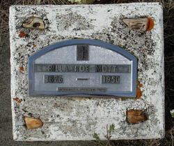

Rilla Effie Roe Mott
| Birth | : | 24 Sep 1876 Helena, Lewis and Clark County, Montana, USA |
| Death | : | 13 Dec 1950 Helena, Lewis and Clark County, Montana, USA |
| Burial | : | Forest Hill Cemetery, Maryville, Blount County, USA |
| Coordinate | : | 35.7052994, -83.9674988 |
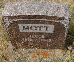
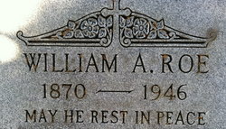
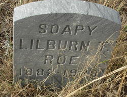
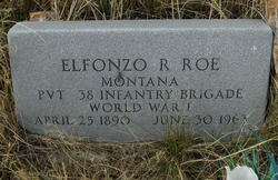
| Description | : | The Independent Record (Helena, Montana) Rilla Mott Dies Here After Lengthy Illness Rilla Mott, 74, of Corbin, widow of Jacob Thomas Mott, died at St. John's Hospital yesterday after an illness of several months.... Mrs. Mott, who was born in Helena, Sept. 24, 1876, had resided at Corbia for the past 30 years. She attended schools in Boulder and was a member of Sts. Cyril and Methodius Roman Catholic Church in East Helena. Her husband died Feb 23, 1945. Survivors include a son, George Davey of Menan, Idaho; a brother Elfanzo Roe of Boulder, 3 grandchildren and... Read More |
frequently asked questions (FAQ):
-
Where is Rilla Effie Roe Mott's memorial?
Rilla Effie Roe Mott's memorial is located at: Forest Hill Cemetery, Maryville, Blount County, USA.
-
When did Rilla Effie Roe Mott death?
Rilla Effie Roe Mott death on 13 Dec 1950 in Helena, Lewis and Clark County, Montana, USA
-
Where are the coordinates of the Rilla Effie Roe Mott's memorial?
Latitude: 35.7052994
Longitude: -83.9674988
Family Members:
Parent
Spouse
Siblings

Children
Flowers:


Nearby Cemetories:
1. Forest Hill Cemetery
Maryville, Blount County, USA
Coordinate: 35.7052994, -83.9674988
2. Long Crooked Creek Family Cemetery
Maryville, Blount County, USA
Coordinate: 35.7071700, -83.9617900
3. Cupp Simerly Cemetery
Maryville, Blount County, USA
Coordinate: 35.7136002, -83.9432983
4. Saint Paul Evangelical Lutheran Church Columbarium
Maryville, Blount County, USA
Coordinate: 35.7259800, -83.9917900
5. Faith Encounter Church Cemetery
Maryville, Blount County, USA
Coordinate: 35.7265520, -83.9432290
6. Saint Johns Lutheran Cemetery
Blount County, USA
Coordinate: 35.7233009, -83.9383011
7. Old Piney Grove Cemetery
Blount County, USA
Coordinate: 35.6856003, -83.9328003
8. Russell Family Cemetery
Blount County, USA
Coordinate: 35.7112400, -83.9257400
9. Hamil Cemetery
Maryville, Blount County, USA
Coordinate: 35.6884110, -84.0051150
10. Liberty Christian Church Cemetery
Montvale, Blount County, USA
Coordinate: 35.6681300, -83.9657700
11. Pecks Chapel Cemetery
Maryville, Blount County, USA
Coordinate: 35.7336006, -83.9375000
12. Maple Grove Missionary Baptist Church Cemetery
Maryville, Blount County, USA
Coordinate: 35.6853680, -84.0066150
13. Six Mile Cemetery
Blount County, USA
Coordinate: 35.6643982, -83.9574966
14. Pleasant Hill Cemetery
Maryville, Blount County, USA
Coordinate: 35.7355995, -83.9317017
15. Chilhowee View Cemetery
Maryville, Blount County, USA
Coordinate: 35.7356186, -83.9314194
16. Carpenters Campground Cemetery
Maryville, Blount County, USA
Coordinate: 35.6719017, -84.0008011
17. College Cemetery
Maryville, Blount County, USA
Coordinate: 35.7493600, -83.9607400
18. Magnolia Cemetery
Maryville, Blount County, USA
Coordinate: 35.7503014, -83.9705963
19. Russell Cemetery
Blount County, USA
Coordinate: 35.7164200, -83.9129600
20. Old Quaker Cemetery
Blount County, USA
Coordinate: 35.7516600, -83.9813200
21. McGinley Cemetery
Blount County, USA
Coordinate: 35.7243996, -83.9131012
22. New Providence Cemetery
Maryville, Blount County, USA
Coordinate: 35.7532997, -83.9728012
23. Maple Grove Cemetery
Maryville, Blount County, USA
Coordinate: 35.7514153, -83.9898529
24. Fellowship Baptist Cemetery
Maryville, Blount County, USA
Coordinate: 35.7472000, -84.0017014