
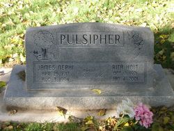


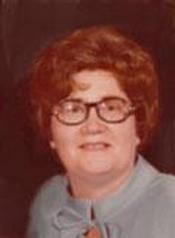
Rita Holt Pulsipher
| Birth | : | 2 Oct 1921 Saint George, Washington County, Utah, USA |
| Death | : | 4 Jan 2001 Saint George, Washington County, Utah, USA |
| Burial | : | Los Molinos Cemetery, Los Molinos, Tehama County, USA |
| Coordinate | : | 40.0475650, -122.1011820 |
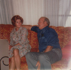
| Description | : | MESQUITE, Nev. - Rita Holt Pulsipher, age 79, died Thursday, January 4, 2001 in St. George, Utah. She was born October 2, 1921 in St. George, Utah to Henry Jesse and Lillis Burgess Holt. She married James Nephi Pulsipher November 10, 1939 in the St. George LDS Temple. He preceded her in death in August of 1994. Raised in St. George, Utah, Mrs. Pulsipher lived in Mesquite, Nevada throughout most her life. She and her husband built and operated the LaMesa Motel. After selling the motel, they managed the Western Village from 1961 to 1975. They purchased the Rio Virgin Telephone... Read More |
frequently asked questions (FAQ):
-
Where is Rita Holt Pulsipher's memorial?
Rita Holt Pulsipher's memorial is located at: Los Molinos Cemetery, Los Molinos, Tehama County, USA.
-
When did Rita Holt Pulsipher death?
Rita Holt Pulsipher death on 4 Jan 2001 in Saint George, Washington County, Utah, USA
-
Where are the coordinates of the Rita Holt Pulsipher's memorial?
Latitude: 40.0475650
Longitude: -122.1011820
Family Members:
Flowers:


Nearby Cemetories:
1. Los Molinos Cemetery
Los Molinos, Tehama County, USA
Coordinate: 40.0475650, -122.1011820
2. Tehama Cemetery
Tehama, Tehama County, USA
Coordinate: 40.0233002, -122.1433029
3. Growney Ranch Family Cemetery
Red Bluff, Tehama County, USA
Coordinate: 40.1167300, -122.1952500
4. New Clairvaux Abbey Cemetery
Vina, Tehama County, USA
Coordinate: 39.9381450, -122.0641890
5. Vina Cemetery
Vina, Tehama County, USA
Coordinate: 39.9636440, -121.9957070
6. Sunset Hill Cemetery
Corning, Tehama County, USA
Coordinate: 39.9271600, -122.1586100
7. Oak Hill Cemetery
Red Bluff, Tehama County, USA
Coordinate: 40.1699982, -122.2433014
8. Red Bluff Memorial Chapel Mausoleum & Columbarium
Red Bluff, Tehama County, USA
Coordinate: 40.1717130, -122.2466860
9. Saint Mary's Cemetery
Red Bluff, Tehama County, USA
Coordinate: 40.1716995, -122.2521973
10. Kirkwood Cemetery
Corning, Tehama County, USA
Coordinate: 39.8624992, -122.1519012
11. Pine Creek Cemetery
Chico, Butte County, USA
Coordinate: 39.8617240, -121.9842480
12. Red Bank Cemetery
Red Bank, Tehama County, USA
Coordinate: 40.1036970, -122.4458540
13. Cameron-Davis Cemetery
Tehama County, USA
Coordinate: 40.2709800, -121.8778500
14. Orland Masonic Cemetery
Orland, Glenn County, USA
Coordinate: 39.7684760, -122.1943310
15. Elmore Cemetery
Flournoy, Tehama County, USA
Coordinate: 39.8642006, -122.4005966
16. Bragg Cemetery
Nord, Butte County, USA
Coordinate: 39.7750980, -121.9568170
17. Inks Creek Cemetery
Tehama County, USA
Coordinate: 40.3419800, -122.1297100
18. Graves Cemetery
Orland, Glenn County, USA
Coordinate: 39.7827988, -122.2930984
19. Cohasset Cemetery
Cohasset, Butte County, USA
Coordinate: 39.9124880, -121.7333220
20. Benner Family Cemetery
Tehama County, USA
Coordinate: 40.1826890, -121.7183500
21. Cottonwood Creek Ranch Cemetery
Cottonwood, Shasta County, USA
Coordinate: 40.3663100, -122.2598800
22. Paskenta Cemetery
Corning, Tehama County, USA
Coordinate: 39.9002991, -122.5089035
23. Orland Catholic Cemetery
Orland, Glenn County, USA
Coordinate: 39.7030983, -122.1393967
24. Orland IOOF Cemetery
Orland, Glenn County, USA
Coordinate: 39.7026000, -122.1401000