
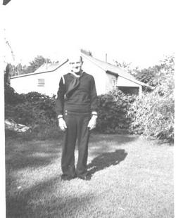
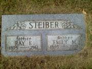
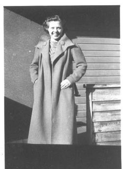
Robert A. Steiber
| Birth | : | 3 Apr 1917 Howard, Miner County, South Dakota, USA |
| Death | : | 5 Oct 1988 Council Bluffs, Pottawattamie County, Iowa, USA |
| Burial | : | Graceland Park Cemetery, Omaha, Douglas County, USA |
| Coordinate | : | 41.2113991, -95.9785995 |
| Description | : | Together they owned and operated The Burlington Lunch resturaunt. |
frequently asked questions (FAQ):
-
Where is Robert A. Steiber's memorial?
Robert A. Steiber's memorial is located at: Graceland Park Cemetery, Omaha, Douglas County, USA.
-
When did Robert A. Steiber death?
Robert A. Steiber death on 5 Oct 1988 in Council Bluffs, Pottawattamie County, Iowa, USA
-
Where are the coordinates of the Robert A. Steiber's memorial?
Latitude: 41.2113991
Longitude: -95.9785995
Family Members:
Parent

Spouse
Children

Flowers:


Nearby Cemetories:
1. Graceland Park Cemetery
Omaha, Douglas County, USA
Coordinate: 41.2113991, -95.9785995
2. Saint Mary Magdalene Cemetery
Omaha, Douglas County, USA
Coordinate: 41.2039420, -95.9850610
3. Saint Mary's Cemetery
Omaha, Douglas County, USA
Coordinate: 41.2042007, -95.9646988
4. Saint Johns Cemetery
Bellevue, Sarpy County, USA
Coordinate: 41.1864014, -95.9682999
5. Westlawn-Hillcrest Memorial Park
Omaha, Douglas County, USA
Coordinate: 41.2346992, -95.9966965
6. Bohemian Cemetery
Omaha, Douglas County, USA
Coordinate: 41.2388992, -95.9955978
7. Douglas County Poor Farm Cemetery
Omaha, Douglas County, USA
Coordinate: 41.2437240, -95.9723480
8. Laurel Hill Cemetery
Omaha, Douglas County, USA
Coordinate: 41.1918983, -95.9417038
9. Fisher Farm Cemetery
Bellevue, Sarpy County, USA
Coordinate: 41.1727982, -95.9760971
10. Hrabik Cemetery
Bellevue, Sarpy County, USA
Coordinate: 41.1726540, -95.9768200
11. Ak-Sar-Ben Racetrack Grounds
Omaha, Douglas County, USA
Coordinate: 41.2414703, -96.0159607
12. Holy Sepulchre Cemetery
Omaha, Douglas County, USA
Coordinate: 41.2543983, -95.9875031
13. Calvary Cemetery
Omaha, Douglas County, USA
Coordinate: 41.2364006, -96.0294037
14. First Central Congregational Columbarium
Omaha, Douglas County, USA
Coordinate: 41.2563456, -95.9658365
15. Beth El Cemetery
Ralston, Douglas County, USA
Coordinate: 41.2117004, -96.0428009
16. Resurrection Cemetery
Omaha, Douglas County, USA
Coordinate: 41.2344208, -96.0365448
17. Evergreen Memorial Park Cemetery
Omaha, Douglas County, USA
Coordinate: 41.2393990, -96.0355988
18. Nash Chapel Crypt
Omaha, Douglas County, USA
Coordinate: 41.2665090, -95.9721790
19. Trinity Cathedral Columbarium
Omaha, Douglas County, USA
Coordinate: 41.2603900, -95.9393660
20. Papillion Cemetery
Papillion, Sarpy County, USA
Coordinate: 41.1758003, -96.0410995
21. Saint Andrews Episcopal Church Columbarium
Omaha, Douglas County, USA
Coordinate: 41.2492500, -96.0427500
22. Countryside Community Church Columbarium
Omaha, Douglas County, USA
Coordinate: 41.2483660, -96.0500270
23. Immanuel Lutheran Church Columbarium
Bellevue, Sarpy County, USA
Coordinate: 41.1602700, -95.9218900
24. Prospect Hill Cemetery
Omaha, Douglas County, USA
Coordinate: 41.2780991, -95.9593964