
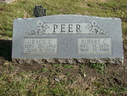

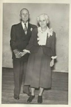

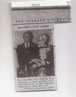
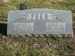
Robert Carl Peer
| Birth | : | 12 Dec 1879 Douglas County, Kansas, USA |
| Death | : | 22 May 1980 Olathe, Johnson County, Kansas, USA |
| Burial | : | Vinland Cemetery, Vinland, Douglas County, USA |
| Coordinate | : | 38.8485985, -95.1763992 |
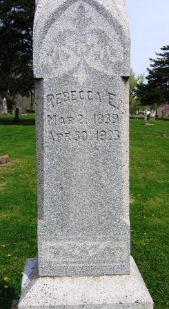
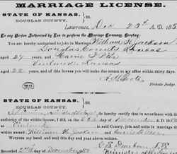
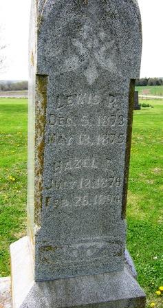
| Description | : | Robert was the son of Robert Arthur Peer and Rebecca Griffis. His siblings were Carrie, William, Dora, Orpha, Minnie, and Hazel. His parents were among the first early settlers of Vinland, Kansas coming from Michigan in a covered wagon in 1866. He lived on a farm in the Vinland area until 1917 when the family moved to a farm near Clearfield, then to Four Corners near Gardner, Kansas before coming to Edgerton, Kansas in 1919. He married Grace McQuiston on November 26, 1903 in Douglas County, Kansas. He worked for the Santa Fe Railroad 26 years then retired... Read More |
frequently asked questions (FAQ):
-
Where is Robert Carl Peer's memorial?
Robert Carl Peer's memorial is located at: Vinland Cemetery, Vinland, Douglas County, USA.
-
When did Robert Carl Peer death?
Robert Carl Peer death on 22 May 1980 in Olathe, Johnson County, Kansas, USA
-
Where are the coordinates of the Robert Carl Peer's memorial?
Latitude: 38.8485985
Longitude: -95.1763992
Family Members:
Parent
Spouse
Siblings

Children
Flowers:


Nearby Cemetories:
1. Stony Point Cemetery
Vinland, Douglas County, USA
Coordinate: 38.8249512, -95.2107391
2. Dow Cemetery
Vinland, Douglas County, USA
Coordinate: 38.8186620, -95.2143000
3. Brumbaugh Cemetery
Douglas County, USA
Coordinate: 38.8319200, -95.2330100
4. Breeze Family Cemetery
Pleasant Grove, Douglas County, USA
Coordinate: 38.8472800, -95.2480400
5. Blue Mound Cemetery
Lawrence, Douglas County, USA
Coordinate: 38.9046600, -95.1865400
6. Ulrich Cemetery
Pleasant Grove, Douglas County, USA
Coordinate: 38.8395740, -95.2531810
7. Clearfield Cemetery
Clearfield, Douglas County, USA
Coordinate: 38.8260002, -95.0930023
8. County Poor Farm Cemetery
Douglas County, USA
Coordinate: 38.9119400, -95.2214600
9. Richland Cemetery
Lawrence, Douglas County, USA
Coordinate: 38.8768997, -95.2630997
10. Kennedy Cemetery
Douglas County, USA
Coordinate: 38.9112900, -95.2269200
11. Marshall Cemetery
Douglas County, USA
Coordinate: 38.9040800, -95.2446700
12. Deay Cemetery
Eudora, Douglas County, USA
Coordinate: 38.8546486, -95.0749435
13. Oakwood Cemetery
Baldwin City, Douglas County, USA
Coordinate: 38.7694016, -95.1825027
14. Pleasant Hill Cemetery
Pleasant Grove, Douglas County, USA
Coordinate: 38.8535995, -95.2794037
15. Prairie City Cemetery
Baldwin City, Douglas County, USA
Coordinate: 38.7689018, -95.2050018
16. Mount Calvary Cemetery
Baldwin City, Douglas County, USA
Coordinate: 38.7687988, -95.2049713
17. Miller Family Cemetery
Baldwin City, Douglas County, USA
Coordinate: 38.7688751, -95.2146683
18. Baldwin City Cemetery
Baldwin City, Douglas County, USA
Coordinate: 38.7612953, -95.1862869
19. Cemetery Beni Israel
Eudora, Douglas County, USA
Coordinate: 38.9280128, -95.1122208
20. Dutton Cemetery
Douglas County, USA
Coordinate: 38.8989800, -95.2790600
21. Black Jack Cemetery
Douglas County, USA
Coordinate: 38.7660400, -95.1159400
22. Franklin Cemetery
Douglas County, USA
Coordinate: 38.9437523, -95.1869431
23. Haskell Cemetery
Lawrence, Douglas County, USA
Coordinate: 38.9353790, -95.2284241
24. Saint Johns Catholic Cemetery
Douglas County, USA
Coordinate: 38.9437900, -95.1919600