
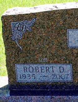

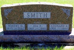
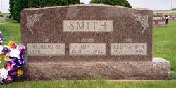
Robert D. Smith
| Birth | : | 1 Oct 1935 |
| Death | : | 25 Oct 2007 Fort Dodge, Webster County, Iowa, USA |
| Burial | : | Cedar Green Cemetery, Clayton, Gloucester County, USA |
| Coordinate | : | 39.6613998, -75.0852966 |
| Description | : | Robert ‘Bob' D. Smith, 72, of Fort Dodge, died Thursday, October 25, 2007 at the Trinity Regional Medical Center. A gathering to celebrate the life of Bob will be held at 1:30 p.m. Monday, October 29, 2007 at the Celebration Center, Friendship Haven. Robert was born October 1, 1935 the son of Leonard and Ida (Conklin) Smith in Fort Dodge, IA. The family then moved to Dayton. Bob later moved to Lanyon, IA and then back to Fort Dodge operating a TV and Radio Repair business in both communities. Bob has been a resident at Friendship Haven since 1980 where his technical... Read More |
frequently asked questions (FAQ):
-
Where is Robert D. Smith's memorial?
Robert D. Smith's memorial is located at: Cedar Green Cemetery, Clayton, Gloucester County, USA.
-
When did Robert D. Smith death?
Robert D. Smith death on 25 Oct 2007 in Fort Dodge, Webster County, Iowa, USA
-
Where are the coordinates of the Robert D. Smith's memorial?
Latitude: 39.6613998
Longitude: -75.0852966
Family Members:
Parent

Siblings
Flowers:


Nearby Cemetories:
1. Cedar Green Cemetery
Clayton, Gloucester County, USA
Coordinate: 39.6613998, -75.0852966
2. Land Of Canaan Cemetery
Glassboro, Gloucester County, USA
Coordinate: 39.6741982, -75.1085968
3. Gloucester County Veterans Memorial Cemetery
Williamstown, Gloucester County, USA
Coordinate: 39.6521279, -75.1163586
4. Downer United Methodist Church Cemetery
Williamstown, Gloucester County, USA
Coordinate: 39.6929700, -75.0523200
5. Aura Methodist Cemetery
Aura, Gloucester County, USA
Coordinate: 39.6725006, -75.1374969
6. Trinity Bible Cemetery
Glassboro, Gloucester County, USA
Coordinate: 39.7003610, -75.1133800
7. Saint Bridgets Cemetery
Glassboro, Gloucester County, USA
Coordinate: 39.7023300, -75.1159000
8. First United Methodist Church Cemetery
Glassboro, Gloucester County, USA
Coordinate: 39.7068900, -75.1081300
9. Franklinville African Methodist Episcopal Cemetery
Gloucester County, USA
Coordinate: 39.6138500, -75.0666600
10. Saint Thomas Episcopal Church Cemetery
Glassboro, Gloucester County, USA
Coordinate: 39.7079200, -75.1101500
11. Chickory Chapel Cemetery
Gloucester County, USA
Coordinate: 39.6244011, -75.1318970
12. Manahath Cemetery
Glassboro, Gloucester County, USA
Coordinate: 39.7154236, -75.1141129
13. Janvier Cemetery
Gloucester County, USA
Coordinate: 39.6194000, -75.0267029
14. Cross Keys Methodist Cemetery
Williamstown, Gloucester County, USA
Coordinate: 39.7124800, -75.0273100
15. Porchtown Zion Methodist Church Cemetery
Franklinville, Gloucester County, USA
Coordinate: 39.5895400, -75.0848000
16. Hardingville Cemetery
Hardingville, Gloucester County, USA
Coordinate: 39.6632100, -75.1790400
17. Williamstown Methodist Cemetery
Williamstown, Gloucester County, USA
Coordinate: 39.6838684, -74.9952698
18. Williamstown Old Methodist Cemetery
Williamstown, Gloucester County, USA
Coordinate: 39.6841812, -74.9935837
19. Williamstown Presbyterian Church Cemetery
Williamstown, Gloucester County, USA
Coordinate: 39.6821938, -74.9890823
20. Cost Family Cemetery
Pitman, Gloucester County, USA
Coordinate: 39.7307100, -75.1332310
21. Bunker Hill Presbyterian Church Cemetery
Gloucester County, USA
Coordinate: 39.7451600, -75.0849200
22. Friendship Methodist Cemetery
Monroeville, Salem County, USA
Coordinate: 39.6219101, -75.1827240
23. Plainville United Methodist Cemetery
Franklinville, Gloucester County, USA
Coordinate: 39.6034400, -75.0047800
24. Brotherhood Cemetery
Williamstown, Gloucester County, USA
Coordinate: 39.6863700, -74.9796200