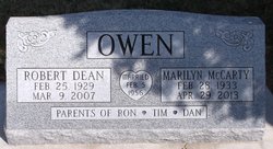
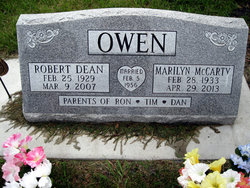
Robert Dean Owen
| Birth | : | 25 Feb 1929 Audubon County, Iowa, USA |
| Death | : | 9 Mar 2007 Polk County, Iowa, USA |
| Burial | : | St. Mary's Churchyard, Denton, South Norfolk District, England |
| Coordinate | : | 52.4364500, 1.3618770 |
| Description | : | Robert Owen 78, died Friday, March 9, 2007 at Iowa Methodist Hospital in Des Moines. Funeral service will be 10:30 a.m. Tuesday at the Lytton Presbyterian Church in Lytton. Visitation from 6 to 8 p.m. Monday at the Lampe Funeral Home in Lake City. Robert Owen was born on February 25, 1929 at home in Audubon County , Iowa to parents Henry and Martha (Johnson) Owen. He graduated from Viola High School, Audubon County in 1947. Entered the Air Force January 5, 1951 to January 5, 1955. Twenty eight months of this time was spent in Japan . He married... Read More |
frequently asked questions (FAQ):
-
Where is Robert Dean Owen's memorial?
Robert Dean Owen's memorial is located at: St. Mary's Churchyard, Denton, South Norfolk District, England.
-
When did Robert Dean Owen death?
Robert Dean Owen death on 9 Mar 2007 in Polk County, Iowa, USA
-
Where are the coordinates of the Robert Dean Owen's memorial?
Latitude: 52.4364500
Longitude: 1.3618770
Family Members:
Parent
Spouse
Siblings
Children
Flowers:
Nearby Cemetories:
1. St. Mary's Churchyard
Denton, South Norfolk District, England
Coordinate: 52.4364500, 1.3618770
2. United Reformed Churchyard
Denton, South Norfolk District, England
Coordinate: 52.4465510, 1.3532090
3. All Saints Churchyard
Alburgh, South Norfolk District, England
Coordinate: 52.4362610, 1.3386490
4. Saint Mary Churchyard
Homersfield, Waveney District, England
Coordinate: 52.4191670, 1.3595410
5. St. Mary Churchyard
Flixton (West), Waveney District, England
Coordinate: 52.4292500, 1.3995130
6. Flixton Abbey
Flixton (West), Waveney District, England
Coordinate: 52.4292800, 1.3996050
7. St George's Churchyard
South Elmham St Cross, Waveney District, England
Coordinate: 52.4080410, 1.3794272
8. Church of the Assumption of the Blessed Virgin Mar
Redenhall, South Norfolk District, England
Coordinate: 52.4104780, 1.3272680
9. All Saints Churchyard
Earsham, South Norfolk District, England
Coordinate: 52.4480480, 1.4212330
10. St. Margaret's Churchyard
South Elmham St Margaret, Waveney District, England
Coordinate: 52.4047900, 1.4007730
11. All Saints Churchyard
Mendham, Mid Suffolk District, England
Coordinate: 52.3976310, 1.3349670
12. Emmanuel Church Cemetery
Bungay, Waveney District, England
Coordinate: 52.4526800, 1.4382410
13. St. Mary's Churchyard and Priory
Bungay, Waveney District, England
Coordinate: 52.4555100, 1.4375800
14. St Edmunds RC Churchyard
Bungay, Waveney District, England
Coordinate: 52.4550570, 1.4381220
15. St. Peter's Churchyard
Waveney District, England
Coordinate: 52.4114350, 1.4333280
16. Holy Trinity Churchyard
Bungay, Waveney District, England
Coordinate: 52.4553310, 1.4399650
17. Bungay Cemetery
Bungay, Waveney District, England
Coordinate: 52.4475475, 1.4444244
18. Saint Andrews Churchyard
Bedingham, South Norfolk District, England
Coordinate: 52.4902500, 1.3643180
19. All Saints Churchyard
South Elmham St Nicholas, Waveney District, England
Coordinate: 52.3936690, 1.4226680
20. St. Mary's Churchyard
Ditchingham, South Norfolk District, England
Coordinate: 52.4776358, 1.4282946
21. St. Michael's Churchyard
South Elmham St Michael, Waveney District, England
Coordinate: 52.4033450, 1.4406520
22. St. Peter's Churchyard
Hedenham, South Norfolk District, England
Coordinate: 52.4891780, 1.4041660
23. Saint Mary Magdalene Churchyard
Metfield, Mid Suffolk District, England
Coordinate: 52.3773540, 1.3538467
24. Ditchingham Cemetery
Ditchingham, South Norfolk District, England
Coordinate: 52.4793614, 1.4307304


